Pennington County, South Dakota facts for kids
Quick facts for kids
Pennington County
|
|
|---|---|

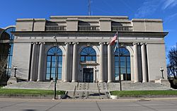
Pennington County Courthouse in Rapid City
|
|

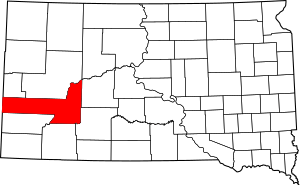
Location within the U.S. state of South Dakota
|
|
 South Dakota's location within the U.S. |
|
| Country | |
| State | |
| Founded | 1875 (created) 1877 (organized) |
| Named for | John L. Pennington |
| Seat | Rapid City |
| Largest city | Rapid City |
| Area | |
| • Total | 2,784 sq mi (7,210 km2) |
| • Land | 2,777 sq mi (7,190 km2) |
| • Water | 7.8 sq mi (20 km2) 0.3% |
| Population
(2020)
|
|
| • Total | 109,222 |
| • Estimate
(2023)
|
115,903 |
| • Density | 39.232/sq mi (15.1476/km2) |
| Time zone | UTC−7 (Mountain) |
| • Summer (DST) | UTC−6 (MDT) |
| Congressional district | At-large |
Pennington County is a county located in the state of South Dakota in the United States. In 2020, about 109,222 people lived there. This makes it the second most populated county in South Dakota. The main city and county seat is Rapid City.
Pennington County was officially created in 1875 and fully set up in 1877. It is named after John L. Pennington. He was the fifth Governor of Dakota Territory when the county was formed. The county is part of the Rapid City metropolitan area. It is also home to the famous Mount Rushmore.
Contents
History of Pennington County
Early Explorations and Gold Rush
In 1874, a US Army group led by George A. Custer explored the Black Hills area. Custer and his officers climbed a tall peak, which they named for General William S. Harney. This peak is now called Black Elk Peak.
The expedition reported finding gold in the Black Hills. This news started a "gold rush" as many people moved into the area. However, these new mining towns went against a treaty signed with the Sioux Nation in 1868. This treaty was called the second Treaty of Fort Laramie.
County Formation and Growth
By 1875, enough people had settled in the area to create a local government. Pennington County was formed on January 11, 1875. It was fully organized by April 19, 1877. The county's borders were changed a few times, in 1877 and 1898.
The first county seat was a mining town called Sheridan. Sheridan was known for having the first Federal Court west of the Missouri River. In 1878, the county seat was moved to Rapid City.
Famous Landmarks and Military Presence
In 1923, Doane Robinson had an idea for a huge sculpture carved into a Black Hills mountain. By 1927, this idea became real, and work on Mount Rushmore began.
During World War II, an Army airbase was built in Pennington County. This base is still active today and is known as Ellsworth Air Force Base. The base has been a very important part of the county's economy ever since.
Geography and Nature
Pennington County is located on the western side of South Dakota. Its western border touches the state of Wyoming. The western part of the county has Black Elk Peak. This is the highest point in the United States east of the Continental Divide.
The western part of the county is rugged and dry, with forests and deep valleys. It gradually changes to rolling hills in the east. The Cheyenne River flows through the middle of the county. Rapid Creek also flows through the western part, joining the Cheyenne River in the middle of the county. The county's elevation ranges from 7,242 ft (2,207 m) at Black Elk Peak to 1,896 ft (578 m) in its northeast corner.
Pennington County covers a total area of 2,784 square miles (7,210 km2). About 2,777 square miles (7,190 km2) is land, and 7.7 square miles (20 km2) (0.3%) is water. It is the third-largest county in South Dakota. It is even larger than the entire state of Delaware.
Main Roads
 Interstate 90
 U.S. Highway 14
 U.S. Highway 16
 U.S. Highway 16A
 U.S. Highway 385
 South Dakota Highway 40
 South Dakota Highway 44
 South Dakota Highway 240
 South Dakota Highway 244
Neighboring Counties
- Meade County – north
- Ziebach County - northeast
- Haakon County – northeast
- Jackson County – southeast
- Oglala Lakota County – south
- Custer County – southwest
- Weston County, Wyoming – west
- Lawrence County – northwest
Protected Natural Areas
Pennington County is home to parts of several important natural areas:
- Badlands National Park
- Black Hills National Forest
- Buffalo Gap National Grassland
- Minuteman Missile National Historic Site
- Mount Rushmore National Memorial
Lakes and Reservoirs
- Deerfield Lake
- Pactola Reservoir
- Shearer Lake
- Sheridan Lake
Population and People
| Historical population | |||
|---|---|---|---|
| Census | Pop. | %± | |
| 1880 | 2,244 | — | |
| 1890 | 6,540 | 191.4% | |
| 1900 | 5,610 | −14.2% | |
| 1910 | 12,453 | 122.0% | |
| 1920 | 12,720 | 2.1% | |
| 1930 | 20,079 | 57.9% | |
| 1940 | 23,799 | 18.5% | |
| 1950 | 34,053 | 43.1% | |
| 1960 | 58,195 | 70.9% | |
| 1970 | 59,349 | 2.0% | |
| 1980 | 70,361 | 18.6% | |
| 1990 | 81,343 | 15.6% | |
| 2000 | 88,565 | 8.9% | |
| 2010 | 100,948 | 14.0% | |
| 2020 | 109,222 | 8.2% | |
| 2023 (est.) | 115,903 | 14.8% | |
| US Decennial Census 1790-1960 1900-1990 1990-2000 2010-2020 |
|||
2020 Census Information
In 2020, the county had 109,222 people living in 44,909 households. The population density was about 39.3 inhabitants per square mile (15.2/km2).
More About the Population
In 2010, there were 100,948 people in the county. Most people (83.6%) were white. About 9.7% were American Indian, and 1.0% were Black or African American. People of Hispanic or Latino background made up 4.0% of the population.
The average age in the county was 36.8 years old. Many households (31.5%) had children under 18 living with them.
Safety and Services
Law Enforcement
The Pennington County Sheriff's Office helps keep the county safe. They have many deputies who patrol, work in the courts, investigate crimes, and run the Pennington County Jail. Their main office is in Rapid City. The current Sheriff is Brian Mueller.
Search and Rescue
The Sheriff's Office also runs the Pennington County Search and Rescue (PCSAR) team. This team is made up of volunteers. It was started in 1973 after a big flood in Rapid City in 1972. The team helps people and visitors in the county and the Black Hills area who are lost or in danger.
Cities and Towns
Cities
- Box Elder
- Hill City
- New Underwood
- Rapid City (county seat)
Towns
Census-Designated Places
These are areas that are like towns but are not officially incorporated.
Unincorporated Communities
These are small communities that do not have their own local government.
- Ajax
- Colonial Pine Hills
- Creighton
- Ellsworth AFB
- Farmingdale
- Hisega
- Imlay
- Owanka
- Merritt (partial)
- Mystic
- Pedro
- Rochford
- Rockerville
- Scenic
- Silver City
- Three Forks
- Wicksville
Ghost Towns
These are towns that used to exist but are now abandoned.
- Addie Camp
- Conata
- Creighton
- Etta
- Moon
- Myers City
- Pactola
- Pedro
- Redfern
- Sheridan
- Teddy Bear
- Tigerville
Education
Several school districts serve the students of Pennington County:
- Custer School District 16-1
- Douglas School District 51-1
- Hill City School District 51-2
- New Underwood School District 51-3
- Rapid City School District 51-4
- Wall School District 51-5
See also
 In Spanish: Condado de Pennington (Dakota del Sur) para niños
 | John T. Biggers |
 | Thomas Blackshear |
 | Mark Bradford |
 | Beverly Buchanan |


