Rockerville, South Dakota facts for kids
Quick facts for kids
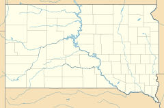
Rockerville, South Dakota
|
|
|---|---|

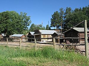
View of Rockerville, July 2006
|
|
| Country | United States |
| State | South Dakota |
| County | Pennington |
| Elevation | 4,370 ft (1,332 m) |
| Time zone | UTC-7 (MST) |
| • Summer (DST) | UTC-6 (MDT) |
| Area code(s) | 605 |
| GNIS feature ID | 5768511 |
Rockerville is a small community in Pennington County, South Dakota. It is located in the beautiful Black Hills region. This area is not officially a city, but it is a recognized place. It started as a mining camp. People came here looking for gold. The town got its name from "rockers." These were tools used to separate gold from river gravel.
Contents
Rockerville's Story
Rockerville began in 1876. This was during a time when many people rushed to the Black Hills to find gold.
A Tourist Hotspot
In the 1950s and 1960s, Rockerville became a popular place for tourists. It was perfectly located on US Highway 16. This highway connects Rapid City to the famous Mount Rushmore National Memorial.
The town had many fun things for visitors to do. There was a live theatre that put on "Mellerdrammer" shows. This is an old-fashioned type of play. There was also a "Ghost town" with different buildings. These buildings had tourist shops and small games. You could visit the "It's a Small World" Museum. It showed a tiny model town from the 1880s and other small collections.
Visitors could stay at a motel or in campgrounds and RV parks. In the 1970s and 1980s, Rockerville was still a busy tourist spot. People enjoyed daily wild west shows and exciting shootouts. They could also take stagecoach rides and try gold panning. The Gaslight Restaurant offered great food. Travelers could also stay at the Trading Post Motel. They could buy groceries and gas up their cars at the Rockerville Trading Post.
Changes and Challenges
In the 1960s, US Highway 16 was made wider. It became a four-lane road. This change caused a problem for Rockerville. The original town ended up between the two new parts of the highway. It was hard to widen the road without destroying the town. Even with new exits, the town's visibility changed.
By the 1990s, fewer tourists stopped in Rockerville. Cars drove by too fast to see the businesses. This made the local economy struggle. This problem is sometimes called "Rockerville Syndrome" in South Dakota. It has taught planners important lessons. Now, when new highways are built, they try to help small towns. This happened with highway projects near Hill City and Corson.
Today, most of the old tourist businesses in Rockerville are gone. They have closed or been taken down. The only business left in the main part of town is the Gaslight Saloon. It was recently rebuilt after a fire.
Rockerville's Location
Today, Rockerville is surrounded by new neighborhoods. These are places where people live in the countryside. The town also has a sawmill and other businesses. It's like the town itself is a doughnut hole.
Rockerville is close to Rapid City, Hill City, and Keystone. This makes it a good place for people who work in those towns to live. About a mile east, along US Highway 16, is "East Rockerville" or "Rockerville Flats." This area has more tourist businesses and homes.
Nearby Areas
To the west of Rockerville is Silver Mountain Road. This used to be part of US Highway 16. Along this road is the community of Silver Mountain. It includes the Storm Mountain Center, which is a camping facility.
The Flume Trail is a hiking path nearby. It follows the path of an old water channel. This channel was built in the 1880s to bring water to the gold rockers. The Flume Trail connects Rockerville, Storm Mountain, and Boulder Hills to Sheridan Lake.
Also to the west is Beretta Gulch. This is land managed by the US Forest Service. Many local people use it as a place for target practice. The Keystone Wye is also nearby. This is where US 16 and US 16A split. It was once famous for having the world's largest timber arch bridge.
The Stratosphere Bowl
About 1.5 miles (2.4 km) northeast of Rockerville is the Stratosphere Bowl. This is a natural dip in the ground. It is located in the valley of Spring Creek.
The Stratosphere Bowl became famous in the 1930s. It was the launch site for two special balloons. These balloons were called Explorer II. They were part of a project by the US Army and the Smithsonian Institution. The balloons carried people high up into the Stratosphere, which is a layer of Earth's atmosphere. The Stratosphere Bowl is located at 43°58′36″N 103°20′43″W / 43.97667°N 103.34528°W.
 | Toni Morrison |
 | Barack Obama |
 | Martin Luther King Jr. |
 | Ralph Bunche |


