Lawrence County, South Dakota facts for kids
Quick facts for kids
Lawrence County
|
|
|---|---|

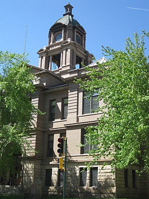
Lawrence County Courthouse in Deadwood
|
|

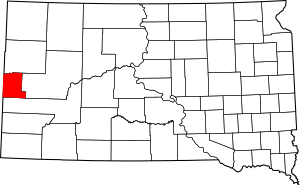
Location within the U.S. state of South Dakota
|
|
 South Dakota's location within the U.S. |
|
| Country | |
| State | |
| Founded | January 11, 1875 (created) 1877 (organized) |
| Named for | John Lawrence |
| Seat | Deadwood |
| Largest city | Spearfish |
| Area | |
| • Total | 800 sq mi (2,000 km2) |
| • Land | 800 sq mi (2,000 km2) |
| • Water | 0.3 sq mi (0.8 km2) 0.03% |
| Population
(2020)
|
|
| • Total | 25,768 |
| • Estimate
(2023)
|
28,053 |
| • Density | 32.2/sq mi (12.4/km2) |
| Time zone | UTC−7 (Mountain) |
| • Summer (DST) | UTC−6 (MDT) |
| Congressional district | At-large |
Lawrence County is a special area called a county in the state of South Dakota, USA. In 2020, about 25,768 people lived here. This makes it the 8th biggest county in South Dakota by population. The main town, or 'county seat,' is Deadwood.
Lawrence County is also part of the Spearfish area. This area is connected to the bigger Rapid City area.
Contents
History of Lawrence County
Lawrence County was officially created on January 11, 1875. It was fully set up and organized in 1877. The county got its name from "Colonel" John Lawrence. He was the first treasurer of the county in 1877.
John Lawrence was an important person in the Dakota Territory. He worked in the government there. He also served as a Sergeant at Arms for the US House of Representatives. Later, he became a US Marshal for the Dakota territory.
Even after he stopped working full-time, he helped the county. He was a road supervisor and an election judge. The title "Colonel" was an honor given to him by the governor.
Geography of Lawrence County
Lawrence County is located on the western side of South Dakota. Its western border touches the state of Wyoming. The county has mountains in the south and west. These mountains become hills in the northeast part of the county.
A small river, part of the Redwater River, flows along the northern border. The land generally slopes down towards the northeast. The highest point in the county is Crooks Tower, which is 7,137 feet tall. The county covers a total area of about 800 square miles. Almost all of this is land, with only a tiny bit of water.
Major Roads in Lawrence County
Neighboring Counties
- Butte County - north
- Meade County - east
- Pennington County - south
- Weston County, Wyoming - southwest
- Crook County, Wyoming - west
Protected Natural Areas
Lawrence County is home to several protected natural areas. These places help keep nature safe and beautiful. Some of them include:
- Black Hills National Forest (part of it)
- Beilage Hepler State Game Production Area
- Coxes-Mirror Lakes State Game Production Area
- Harrison-Badger-Trucano State Game Production Area
- Iron Creek Lake State Game Production Area
- Reausaw Lake State Game Production Area
- Spearfish Canyon State Nature Area
People and Population
| Historical population | |||
|---|---|---|---|
| Census | Pop. | %± | |
| 1880 | 13,218 | — | |
| 1890 | 11,673 | −11.7% | |
| 1900 | 17,897 | 53.3% | |
| 1910 | 19,694 | 10.0% | |
| 1920 | 13,029 | −33.8% | |
| 1930 | 13,920 | 6.8% | |
| 1940 | 19,093 | 37.2% | |
| 1950 | 16,648 | −12.8% | |
| 1960 | 17,075 | 2.6% | |
| 1970 | 17,453 | 2.2% | |
| 1980 | 18,339 | 5.1% | |
| 1990 | 20,655 | 12.6% | |
| 2000 | 21,802 | 5.6% | |
| 2010 | 24,097 | 10.5% | |
| 2020 | 25,768 | 6.9% | |
| 2023 (est.) | 28,053 | 16.4% | |
| U.S. Decennial Census 1790-1960 1900-1990 1990-2000 2010-2020 |
|||
Population in 2020
In 2020, the census showed that 25,768 people lived in Lawrence County. There were 11,444 households, which are groups of people living together. The average number of people per square mile was about 32.2.
About 23.10% of the people were under 18 years old. About 14.60% were 65 years or older. The average age of people in the county was 37 years old. For every 100 females, there were about 96.80 males.
The average income for a household was $31,755. For families, the average income was $40,501. About 14.80% of the people in the county lived below the poverty line. This included 15.70% of those under 18.
Communities in Lawrence County
Cities in Lawrence County
- Central City
- Deadwood (This is the county seat, or main town)
- Lead
- Spearfish
- Whitewood
Special Places (Census-Designated)
These are areas that are like towns but are not officially incorporated as cities.
- Boulder Canyon
- Crook City
- Mountain Plains
- North Spearfish
- Saint Onge
Other Small Communities
These are smaller places that are not officially part of a city or census-designated area.
- Beaver Crossing
- Brownsville
- Cheyenne Crossing
- Chinatown
- Dumont
- Elmore
- Englewood
- Galena
- Gayville
- Hanna
- Nemo
- Preston
- Roubaix
- Savoy
Ghost Towns
These are towns that used to exist but are now mostly empty or abandoned.
- Blacktail
- Greenwood
- Lincoln AKA Carterville
- AKA Midland or Garden City
- Merritt (partially a ghost town)
- Nahant
- Terraville
- Tinton
- Trojan (AKA Portland)
Townships and Unorganized Areas
Lawrence County also has townships and areas that are not part of any city or town.
- St. Onge Township
- North Lawrence (an area without a formal local government)
- South Lawrence (an area without a formal local government)
Education in Lawrence County
Children in Lawrence County attend schools in several different school districts. These districts manage the public schools in the area.
- Belle Fourche School District 09-1
- Lead-Deadwood School District 40-1
- Meade School District 46-1
- Spearfish School District 40-2
See also
 In Spanish: Condado de Lawrence (Dakota del Sur) para niños
 | Stephanie Wilson |
 | Charles Bolden |
 | Ronald McNair |
 | Frederick D. Gregory |


