Butte County, South Dakota facts for kids
Quick facts for kids
Butte County
|
|
|---|---|

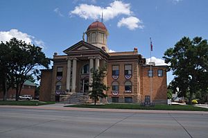
Butte County Courthouse
|
|

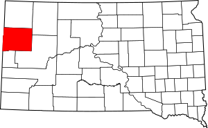
Location within the U.S. state of South Dakota
|
|
 South Dakota's location within the U.S. |
|
| Country | |
| State | |
| Founded | March 2, 1883 May 6, 1883 |
| Named for | Hills in the county |
| Seat | Belle Fourche |
| Largest city | Belle Fourche |
| Area | |
| • Total | 2,266 sq mi (5,870 km2) |
| • Land | 2,250 sq mi (5,800 km2) |
| • Water | 16 sq mi (40 km2) 0.7% |
| Population
(2020)
|
|
| • Total | 10,243 |
| • Estimate
(2023)
|
10,863 |
| • Density | 4.5203/sq mi (1.7453/km2) |
| Time zone | UTC−7 (Mountain) |
| • Summer (DST) | UTC−6 (MDT) |
| Congressional district | At-large |
Butte County is a county in the state of South Dakota. It is located in the western part of the state. In 2020, about 10,243 people lived here. The main town and county seat is Belle Fourche. The county was started on March 2, 1883. Its name comes from a French word for a hill, because of the hills in the area.
Contents
History
Ancient Times
Butte County has a very long history, even before people lived there! In 1975, scientists found fossils of plesiosaurs. These were huge swimming reptiles that lived about 110 million years ago. Imagine finding a dinosaur in your backyard!
Later, in the 1980s, a 90-million-year-old fossil of a clawless lobster was found. And in 1981, a skeleton of a famous Tyrannosaurus rex was discovered.
People have lived in the Belle Fourche River Valley for a very long time. The earliest signs of humans are from around 3000 BC. These first people were Native Americans. They lived on the plains of North America.
Scientists have found traces of tipi rings from this time. These are circles of stones that held down the edges of tipis. In the late 1970s and early 1980s, archaeologists explored an old site west of Belle Fourche. This site was called the Smiley-Evans Site. It showed that people lived there around 1000 AD. By 1989, many more ancient sites had been found in the county.
Geography
Location and Landscape
Butte County is on the western edge of South Dakota. It shares borders with Montana to the northwest and Wyoming to the southwest. The land here has rolling hills and is quite dry. Water flows through many small streams that go from northwest to southeast.
Some parts of the county are used for farming. Farmers use special watering systems called center pivot irrigation. The land generally slopes down towards the southeast. The highest point in the county is about 3,865 feet (1,178 meters) above sea level. This high point is on the western border.
The county covers a total area of 2,266 square miles (5,869 square kilometers). Most of this, 2,250 square miles (5,827 square kilometers), is land. Only a small part, 16 square miles (41 square kilometers), is water.
Roads and Neighbors
You can travel through Butte County on several important roads:
Butte County is surrounded by other counties:
- Harding County - north
- Perkins County - northeast
- Meade County - southeast
- Lawrence County - southwest
- Crook County, Wyoming - west
- Carter County, Montana - northwest
Nature Spots
Butte County has several protected areas where you can enjoy nature:
- Belle Fourche Dam State Game Production Area
- Belle Fourche National Wildlife Refuge
- Newell Lake State Game Production Area
- Newell Lake State Lakeside Use Area
- Rocky Point State Recreation Area
People of Butte County
| Historical population | |||
|---|---|---|---|
| Census | Pop. | %± | |
| 1890 | 1,037 | — | |
| 1900 | 2,907 | 180.3% | |
| 1910 | 4,993 | 71.8% | |
| 1920 | 6,819 | 36.6% | |
| 1930 | 8,589 | 26.0% | |
| 1940 | 8,004 | −6.8% | |
| 1950 | 8,161 | 2.0% | |
| 1960 | 8,592 | 5.3% | |
| 1970 | 7,825 | −8.9% | |
| 1980 | 8,372 | 7.0% | |
| 1990 | 7,914 | −5.5% | |
| 2000 | 9,094 | 14.9% | |
| 2010 | 10,110 | 11.2% | |
| 2020 | 10,243 | 1.3% | |
| 2023 (est.) | 10,863 | 7.4% | |
| U.S. Decennial Census 1790-1960 1900-1990 1990-2000 2010-2020 |
|||
The population of Butte County has grown over the years. In 2020, there were 10,243 people living there. This means there were about 4.6 people for every square mile. There were also 4,196 households, which are groups of people living together.
In 2010, the county had 10,110 people. The average age of people in Butte County was about 41 years old. Many households had children under 18 living with them.
Towns and Cities
Main Towns
- Belle Fourche (This is the county seat, meaning it's where the main government offices are.)
- Newell
Smaller Communities
Local Areas
- Vale (This is a special area called a Census-designated place.)
There are also several small, unincorporated communities. This means they are not officially organized as towns or cities:
- Arpan
- Castle Rock
- East Butte
- Hoover
- Minnesela
- West Butte
The county also has a few townships, which are smaller local government areas:
- Union
- Vale
See also
 In Spanish: Condado de Butte (Dakota del Sur) para niños
 | Bayard Rustin |
 | Jeannette Carter |
 | Jeremiah A. Brown |

