Fruitdale, South Dakota facts for kids
Quick facts for kids
Fruitdale, South Dakota
|
|
|---|---|
|
Town
|
|

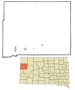
Location in Butte County and the state of South Dakota
|
|
| Country | United States |
| State | South Dakota |
| County | Butte |
| Founded | 1910 |
| Area | |
| • Total | 0.27 sq mi (0.71 km2) |
| • Land | 0.27 sq mi (0.71 km2) |
| • Water | 0.00 sq mi (0.00 km2) |
| Elevation | 2,956 ft (901 m) |
| Population
(2020)
|
|
| • Total | 73 |
| • Density | 266.42/sq mi (102.69/km2) |
| Time zone | UTC-7 (Mountain (MST)) |
| • Summer (DST) | UTC-6 (MDT) |
| ZIP code |
57717
|
| Area code(s) | 605 |
| FIPS code | 46-23140 |
| GNIS feature ID | 1267397 |
Fruitdale is a small town in Butte County, South Dakota, United States. In 2020, 73 people lived there. The town was started in 1911. It got its name because there was a fruit orchard nearby.
Town Geography
Fruitdale is a small town. It covers about 0.71 square kilometers (0.27 square miles) of land. There is no water area within the town.
Town Population
This section shows how the number of people living in Fruitdale has changed over the years.
| Historical population | |||
|---|---|---|---|
| Census | Pop. | %± | |
| 1920 | 40 | — | |
| 1930 | 113 | 182.5% | |
| 1940 | 89 | −21.2% | |
| 1950 | 70 | −21.3% | |
| 1960 | 79 | 12.9% | |
| 1970 | 74 | −6.3% | |
| 1980 | 88 | 18.9% | |
| 1990 | 43 | −51.1% | |
| 2000 | 62 | 44.2% | |
| 2010 | 64 | 3.2% | |
| 2020 | 73 | 14.1% | |
| U.S. Decennial Census | |||
People in 2010
In 2010, 64 people lived in Fruitdale. There were 29 homes in the town. Most of the people (98.4%) were White. A small number (1.6%) were from two or more races. About 4.7% of the people were Hispanic or Latino.
The average age of people in Fruitdale was 45.8 years old. About 15.6% of the residents were under 18 years old. About 15.6% were 65 years or older. The town had slightly more females (51.6%) than males (48.4%).
See also
 In Spanish: Fruitdale (Dakota del Sur) para niños
 | Frances Mary Albrier |
 | Whitney Young |
 | Muhammad Ali |

