Harding County, South Dakota facts for kids
Quick facts for kids
Harding County
|
|
|---|---|

|
|

Location within the U.S. state of South Dakota
|
|
 South Dakota's location within the U.S. |
|
| Country | |
| State | |
| Founded | 1881 (created) 1898 (dissolved) 1908 (re-created w revised shape) 1909 (organized) |
| Named for | J. A. Harding |
| Seat | Buffalo |
| Largest town | Buffalo |
| Area | |
| • Total | 2,678 sq mi (6,940 km2) |
| • Land | 2,671 sq mi (6,920 km2) |
| • Water | 6.5 sq mi (17 km2) 0.2% |
| Population
(2020)
|
|
| • Total | 1,311 |
| • Estimate
(2023)
|
1,324 |
| • Density | 0.48954/sq mi (0.18901/km2) |
| Time zone | UTC−7 (Mountain) |
| • Summer (DST) | UTC−6 (MDT) |
| Congressional district | At-large |
Harding County is a county in the state of South Dakota. In 2020, about 1,311 people lived here. This makes it one of the least populated counties in South Dakota. The main town and county seat is Buffalo.
Harding County was first created in 1881 in the Dakota Territory. It was named after J. A. Harding, who was an important leader in the territory. The county's shape changed a few times. In 1898, it was even dissolved and became part of Butte County. But in 1908, Harding County was created again with new borders. Its local government officially started in 1909.
Part of Custer National Forest is in Harding County. South Dakota State University also has a special farm here. It's called the Antelope Range and Livestock Research Station. This station is about 14 miles east of Buffalo.
Contents
Geography
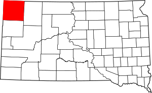
Harding County is in the very northwest corner of South Dakota. To its west is the state of Montana. To its north is North Dakota. The land here has high hills that gently slope towards the east. The highest point is a ridge in the southwest part of the county.
Harding County covers a total area of about 2,678 square miles. Most of this is land, about 2,671 square miles. Only a small part, about 6.5 square miles, is water. It is the fourth-largest county in South Dakota by size.
Major roads
Neighboring counties
- Bowman County, North Dakota - north
- Adams County, North Dakota - northeast
- Perkins County - east
- Butte County - south
- Carter County, Montana - west
- Fallon County, Montana - northwest
Protected natural areas
- Custer National Forest (part of it)
- Gardner Lake State Game Production Area
- Mallula State Game Production Area
- State Experiment Farm and Antelope Reserve
Lakes
- Lake Gardner: This lake is 203 acres big and about 14 feet deep. You can find Channel Catfish, Largemouth Bass, Walleye, Yellow Bullhead, and Yellow Perch here.
- Leger Dam
- Rabbit Creek Dam: This lake is 17 acres big. It has different kinds of warm water fish, including Largemouth Bass.
- Vessey Dam: This lake is 8 acres big and is stocked with rainbow trout.
People and population
| Historical population | |||
|---|---|---|---|
| Census | Pop. | %± | |
| 1910 | 4,228 | — | |
| 1920 | 3,953 | −6.5% | |
| 1930 | 3,589 | −9.2% | |
| 1940 | 3,010 | −16.1% | |
| 1950 | 2,289 | −24.0% | |
| 1960 | 2,371 | 3.6% | |
| 1970 | 1,855 | −21.8% | |
| 1980 | 1,700 | −8.4% | |
| 1990 | 1,669 | −1.8% | |
| 2000 | 1,353 | −18.9% | |
| 2010 | 1,255 | −7.2% | |
| 2020 | 1,311 | 4.5% | |
| 2023 (est.) | 1,324 | 5.5% | |
| U.S. Decennial Census 1790-1960 1900-1990 1990-2000 2010-2020 |
|||
2020 population count
In 2020, there were 1,311 people living in Harding County. There were 537 households and 358 families. The county had about 0.5 people per square mile.
2010 population count
In 2010, there were 1,255 people in the county. Most people were white (95.9%). About 1.5% were American Indian. A small number of people were from other backgrounds. About 1.6% of the people were of Hispanic or Latino origin. Many people had family roots from Norway (41.4%) and Germany (31.8%).
Communities
Towns
- Buffalo (county seat)
- Camp Crook
Unincorporated communities
Ghost towns
See also
 In Spanish: Condado de Harding (Dakota del Sur) para niños
 | Misty Copeland |
 | Raven Wilkinson |
 | Debra Austin |
 | Aesha Ash |

