Fallon County, Montana facts for kids
Quick facts for kids
Fallon County
|
|
|---|---|

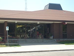
Fallon County Courthouse in Baker
|
|

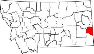
Location within the U.S. state of Montana
|
|
 Montana's location within the U.S. |
|
| Country | |
| State | |
| Founded | December 9, 1913 |
| Seat | Baker |
| Largest city | Baker |
| Area | |
| • Total | 1,623 sq mi (4,200 km2) |
| • Land | 1,621 sq mi (4,200 km2) |
| • Water | 2.3 sq mi (6 km2) 0.1% |
| Population
(2020)
|
|
| • Total | 3,049 |
| • Estimate
(2022)
|
3,011 |
| • Density | 1.8786/sq mi (0.7253/km2) |
| Time zone | UTC−7 (Mountain) |
| • Summer (DST) | UTC−6 (MDT) |
| Congressional district | 2nd |
|
|
Fallon County is a special area in the state of Montana, USA. It's like a big neighborhood with its own local government. In 2020, about 3,049 people lived there. The main town, or county seat, is Baker.
Fallon County was created in 1913. It was formed from a part of Custer County. The county is named after Benjamin O'Fallon. He was the nephew of Captain William Clark, a famous explorer. Benjamin O'Fallon worked as an agent for Native American tribes in the Missouri region from 1823 to 1827.
Contents
Geography of Fallon County
Fallon County is located in eastern Montana. It covers a total area of about 1,623 square miles (4,203 square kilometers). Most of this area, about 1,621 square miles (4,198 square kilometers), is land. Only a small part, about 2.3 square miles (6 square kilometers), is water.
Neighboring Counties
Fallon County shares its borders with several other counties and states:
- Wibaux County to the north
- Prairie County to the northwest
- Custer County to the west
- Carter County to the south
- Harding County, South Dakota to the southeast (in South Dakota)
- Bowman County, North Dakota to the east (in North Dakota)
- Slope County, North Dakota to the east (in North Dakota)
- Golden Valley County, North Dakota to the northeast (in North Dakota)
Population and People
The number of people living in Fallon County has changed over the years. Here's how the population has grown and shrunk:
| Historical population | |||
|---|---|---|---|
| Census | Pop. | %± | |
| 1920 | 4,548 | — | |
| 1930 | 4,568 | 0.4% | |
| 1940 | 3,719 | −18.6% | |
| 1950 | 3,660 | −1.6% | |
| 1960 | 3,997 | 9.2% | |
| 1970 | 4,050 | 1.3% | |
| 1980 | 3,763 | −7.1% | |
| 1990 | 3,103 | −17.5% | |
| 2000 | 2,837 | −8.6% | |
| 2010 | 2,890 | 1.9% | |
| 2020 | 3,049 | 5.5% | |
| 2022 (est.) | 3,011 | 4.2% | |
| U.S. Decennial Census 1790–1960, 1900–1990, 1990–2000, 2010–2020 |
|||
Recent Population Counts
In 2020, the census counted 3,049 people living in Fallon County.
A few years earlier, in 2010, there were 2,890 people. These people lived in 1,233 households, and 810 of these were families. The county had about 1.8 people per square mile. Most of the people living in Fallon County were white (97.4%). A small number were Asian, American Indian, or from other backgrounds. About 1.2% of the population was of Hispanic or Latino origin.
The average age of people in Fallon County in 2010 was about 42.9 years old.
Getting Around
Fallon County has important roads and an airport to help people travel.
Main Roads
Airport
The Baker Municipal Airport is located southeast of Baker. It helps people fly in and out of the area.
Towns and Communities
Fallon County has a few towns and smaller communities where people live.
Cities
- Baker is the largest city and the county seat. This means it's where the main government offices are located.
Towns
- Plevna is another town in Fallon County.
Smaller Communities
There are also several smaller, unincorporated communities. These are places that don't have their own local government like cities or towns do.
- Cabin Creek
- Ollie
- Webster
- Westmore
- Willard
See also
 In Spanish: Condado de Fallon para niños
 | Bayard Rustin |
 | Jeannette Carter |
 | Jeremiah A. Brown |

