Wibaux County, Montana facts for kids
Quick facts for kids
Wibaux County
|
|
|---|---|

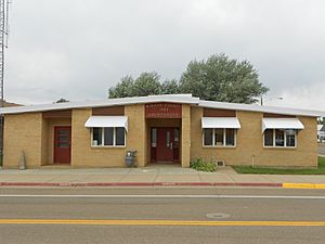
Wibaux County Courthouse in Wibaux
|
|

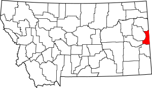
Location within the U.S. state of Montana
|
|
 Montana's location within the U.S. |
|
| Country | |
| State | |
| Founded | August 17, 1914 |
| Named for | Pierre Wibaux |
| Seat | Wibaux |
| Largest town | Wibaux |
| Area | |
| • Total | 890 sq mi (2,300 km2) |
| • Land | 889 sq mi (2,300 km2) |
| • Water | 0.7 sq mi (2 km2) 0.07% |
| Population
(2020)
|
|
| • Total | 937 |
| • Estimate
(2022)
|
919 |
| • Density | 1.053/sq mi (0.4065/km2) |
| Time zone | UTC−7 (Mountain) |
| • Summer (DST) | UTC−6 (MDT) |
| Congressional district | 2nd |
|
|
Wibaux County is a county located in the state of Montana, USA. A county is like a smaller region within a state. In 2020, about 937 people lived here. This makes it one of the least populated counties in Montana. The main town and "county seat" (where the county government is) is Wibaux.
Contents
History of Wibaux County
Wibaux County was created in 1914 by the Montana Legislature. It was formed from parts of other nearby counties: Dawson, Fallon, and Richland Counties.
The county is named after Pierre Wibaux (1858–1913). He was a famous cattle rancher in the late 1800s. Pierre Wibaux was also a friend of Theodore Roosevelt, who later became a U.S. President.
There's a fun story about how the town of Wibaux got its name. It's said that Pierre Wibaux's cowboys surrounded the town, which was then called Mingusville. They wouldn't let anyone leave or enter until they signed a paper to change the town's name to Wibaux! When Pierre Wibaux passed away, his ashes were spread over a hill west of the town. Today, you can see a statue of him on that very hill.
Geography and Land
Wibaux County covers a total area of about 890 square miles. Most of this is land (889 square miles), with a very small amount of water (0.7 square miles). It is the third-smallest county in Montana when you look at its land area.
Neighboring Counties
Wibaux County shares its borders with several other counties:
- Richland County to the north
- Dawson County to the northwest
- Prairie County to the west
- Fallon County to the south
- Golden Valley County, North Dakota to the east (in North Dakota)
- McKenzie County, North Dakota to the northeast (in North Dakota)
Main Roads in Wibaux
These are some important roads that go through Wibaux County:
 Interstate 94 (a major highway connecting states)
 U.S. Highway 10 (an older U.S. highway)
 Montana Highway 7 (a state highway)
 S-261 (another state route)
Protected Natural Areas
- Lamesteer National Wildlife Refuge is a special area in the county. It helps protect wildlife and their homes.
Population Changes
| Historical population | |||
|---|---|---|---|
| Census | Pop. | %± | |
| 1920 | 3,113 | — | |
| 1930 | 2,767 | −11.1% | |
| 1940 | 2,161 | −21.9% | |
| 1950 | 1,907 | −11.8% | |
| 1960 | 1,698 | −11.0% | |
| 1970 | 1,465 | −13.7% | |
| 1980 | 1,476 | 0.8% | |
| 1990 | 1,191 | −19.3% | |
| 2000 | 1,068 | −10.3% | |
| 2010 | 1,017 | −4.8% | |
| 2020 | 937 | −7.9% | |
| 2022 (est.) | 919 | −9.6% | |
| U.S. Decennial Census 1790–1960, 1900–1990, 1990–2000, 2010–2020 |
|||
The table above shows how the number of people living in Wibaux County has changed over many years. This information comes from the U.S. Census, which counts people every ten years. You can see that the population has slowly decreased since 1920.
What the 2020 Census Showed
In 2020, the official count showed that 937 people lived in Wibaux County.
What the 2010 Census Showed
In 2010, there were 1,017 people living in the county. There were 457 households (groups of people living together) and 281 families. The average age of people in the county was 49 years old.
Towns and Communities
Main Town
- Wibaux (This is the county seat, meaning it's where the county government offices are located.)
Other Small Communities
These are smaller places in the county that are not officially towns:
See also
 In Spanish: Condado de Wibaux para niños
 | Selma Burke |
 | Pauline Powell Burns |
 | Frederick J. Brown |
 | Robert Blackburn |

