
McKenzie County, North Dakota facts for kids
Quick facts for kids
McKenzie County
|
|
|---|---|

|
|

Location within the U.S. state of North Dakota
|
|
 North Dakota's location within the U.S. |
|
| Country | |
| State | |
| Founded | March 9, 1883 (created) April 20, 1905 (organized) |
| Named for | Alexander McKenzie |
| Seat | Watford City |
| Largest city | Watford City |
| Area | |
| • Total | 2,861 sq mi (7,410 km2) |
| • Land | 2,760 sq mi (7,100 km2) |
| • Water | 100 sq mi (300 km2) 3.5% |
| Population
(2020)
|
|
| • Total | 14,704 |
| • Estimate
(2023)
|
14,252 |
| • Density | 5.1395/sq mi (1.9844/km2) |
| Time zones | |
| (northern portion) | UTC−6 (Central) |
| • Summer (DST) | UTC−5 (CDT) |
| (southern portion) | UTC−7 (Mountain) |
| • Summer (DST) | UTC−6 (MDT) |
| Congressional district | At-large |
McKenzie County is a special area called a county in the state of North Dakota, USA. In 2020, about 14,704 people lived here. The main town where the county government is located is Watford City.
This county is close to the city of Williston. However, the Census Bureau does not officially include McKenzie County in Williston's larger city area.
Contents
History of McKenzie County
The area that is now McKenzie County was first created on March 9, 1883. This happened when the government of Dakota Territory decided to form new counties. It was named after Alexander McKenzie, a well-known political figure at the time.
At first, the county was just a name on a map. It didn't have its own government right away. Over the years, its borders changed a few times. There were even plans to get rid of the county completely, but these plans didn't happen.
Finally, on April 20, 1905, McKenzie County officially set up its own government. This meant it could manage its own affairs.
The first main town, or county seat, was Alexander. Later, in 1907, the county seat moved to Schafer. In 1941, it moved again to its current location, Watford City.
Between 2010 and 2020, McKenzie County grew faster than any other county in the United States. Its population more than doubled! This big growth was mainly because of the oil boom in the Bakken Formation area.
Exploring McKenzie County's Geography
McKenzie County is located on the western side of North Dakota. Its western border touches the state of Montana.
The Missouri River flows along the northern part of the county. A large part of the Missouri River here is actually Lake Sakakawea, a big lake formed by a dam. The Yellowstone River also flows into the county from Montana and joins the Missouri River.
The Little Missouri River winds through the southern part of the county. It eventually flows into Lake Sakakawea.
The land in McKenzie County has rolling hills and river valleys. It's a mix of dry areas and places used for farming. The highest point is about 2,684 feet (818 meters) above sea level. McKenzie County is the largest county in North Dakota by land area.
The county has many different types of landscapes. You can find sugarbeet fields near the Missouri River. In the south, there are rugged badlands near the Little Missouri River. This is where parts of Theodore Roosevelt National Park and the Little Missouri National Grassland are located.
Between the two main rivers, there are large areas of prairie. These prairies can be gently rolling or have rocky, rough pastures. The southeastern part of the county is rich in wildlife. It also has groves of quaking aspen trees and bur oak trees.
Some parts of McKenzie County are in the Mountain Time Zone. Other parts are in the Central Time Zone. This means the time can be different depending on where you are in the county!
Major Roads in McKenzie County
 U.S. Highway 85
 North Dakota Highway 22
 North Dakota Highway 23
 North Dakota Highway 58
 North Dakota Highway 68
 North Dakota Highway 73
 North Dakota Highway 200
 North Dakota Highway 1806
Neighboring Counties
- Williams County - north (Central Time)
- Mountrail County - northeast (Central Time)
- Dunn County - southeast (Mountain Time in western section)
- Billings County - south (Mountain Time)
- Golden Valley County - southwest (Mountain Time)
- Wibaux County, Montana - west (Mountain Time)
- Richland County, Montana - northwest (Mountain Time)
Special Protected Areas
- Antelope Creek State Game Management Area
- Antelope Creek State Wildlife Refuge
- Bear Den Creek Public Use Area
- Little Missouri National Grassland (part)
- Maah Daah Hey Trail
- Theodore Roosevelt National Park (North Unit)
- Tobacco Garden Creek State Game Management Area
- Tobacco Garden Creek Recreation Area
Lakes in McKenzie County
- Demicks Lake
- Lake Sakakawea
- Nohly Lake
Population and People
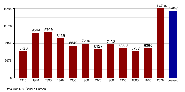
| Historical population | |||
|---|---|---|---|
| Census | Pop. | %± | |
| 1910 | 5,720 | — | |
| 1920 | 9,544 | 66.9% | |
| 1930 | 9,709 | 1.7% | |
| 1940 | 8,426 | −13.2% | |
| 1950 | 6,849 | −18.7% | |
| 1960 | 7,296 | 6.5% | |
| 1970 | 6,127 | −16.0% | |
| 1980 | 7,132 | 16.4% | |
| 1990 | 6,383 | −10.5% | |
| 2000 | 5,737 | −10.1% | |
| 2010 | 6,360 | 10.9% | |
| 2020 | 14,704 | 131.2% | |
| 2023 (est.) | 14,252 | 124.1% | |
| U.S. Decennial Census 1790-1960 1900-1990 1990-2000 2010-2020 |
|||
In 2020, the census counted 14,704 people living in McKenzie County. There were 5,416 households, which are groups of people living together. The county had 7,661 housing units available.
Back in the 2010 census, there were 6,360 people. The population density was about 2.30 people per square mile. Most people in the county were white, and a significant number were American Indian.
Many households in 2010 had children under 18 living with them. The average household had about 2.58 people. The average age of people living in the county was 38.0 years old.
How the Population Changed Over Time
Towns and Communities
Cities in McKenzie County
- Alexander
- Arnegard
- Watford City (This is the county seat, where the main government offices are.)
Special Census-Designated Places
These are areas that are like towns but are not officially incorporated as cities.
Smaller Unincorporated Communities
These are smaller settlements that don't have their own local government.
- Banks
- Cartwright
- Charbonneau
- Charlson
- Dore
- Grassy Butte
- Hawkeye
- Johnsons Corner (or Johnson Corner)
- Keene
- Kroff
- Rawson
- Schafer
Townships in McKenzie County
Townships are smaller local government areas within a county.
- Alex
- Antelope Creek
- Arnegard
- Blue Butte
- Charbon
- Elm Tree
- Ellsworth
- Grail
- Hawkeye
- Keene
- Randolph
- Riverview
- Sioux
- Tri
- Twin Valley
- Yellowstone
Former Townships
Some townships have merged or changed over time.
- Elk, Poe, and Wilbur townships joined together on January 1, 2002, to form Tri Township.
Education in McKenzie County
Here are the school districts that serve students in McKenzie County:
Schools for All Grades (K-12)
- Alexander Public School District 2
- Mandaree Public School District 36
- McKenzie County Public School District 1
- New Town Public School District 1
- Williston Basin School District 7
Elementary Schools
These districts focus on younger students.
- Earl Public School District 18
- Horse Creek Public School District 32
- Yellowstone Public School District 14
Past School Districts
- The Grassy Butte District later merged into the Killdeer district.
- Williston Public School District 1 joined with another district in 2021 to become the Williston Basin district.
See also
 In Spanish: Condado de McKenzie (Dakota del Norte) para niños
