
Lake Sakakawea facts for kids
Quick facts for kids Lake Sakakawea |
|
|---|---|
.png)
Lake Sakakawea highlighted in light blue on Missouri River Basin map
|
|

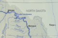
Lake Sakakawea
Location in North Dakota

Lake Sakakawea
Location in the United States
|
|
| Location | |
| Coordinates | 47°30′N 101°25′W / 47.50°N 101.41°W at Garrison Dam |
| Lake type | Reservoir |
| Primary inflows | Missouri River, Little Missouri River, Milk River, and Yellowstone River. |
| Primary outflows | Missouri River |
| Catchment area | 317,400 km2 (122,500 sq mi) |
| Max. length | 178 miles (286 km) |
| Surface area | 307,000 acres (480 sq mi; 1,240 km2) |
| Max. depth | 180 ft (55 m) at dam |
| Water volume | 23,800,000 acre⋅ft (29.4 km3) |
| Shore length1 | 1,320 miles (2,120 km) |
| Surface elevation | 1,817 ft (554 m) |
| Settlements | Williston, Pick City, Four Bears Village, and Riverdale, North Dakota |
| 1 Shore length is not a well-defined measure. | |
Lake Sakakawea is a very large reservoir (a man-made lake) in the north-central United States. It was created in 1953 by the Garrison Dam. This dam was built by the United States Army Corps of Engineers on the Missouri River in central North Dakota.
The lake is named after Sakakawea, a brave Shoshone-Hidatsa woman. It is the biggest man-made lake completely inside North Dakota. It's also the second largest lake in the United States by size, after Lake Oahe. By the amount of water it holds, it's the third largest in the U.S., after Lake Mead and Lake Powell.
Lake Sakakawea is about 50 miles (80 km) from Bismarck, the state capital. The lake is usually 2 to 3 miles (3.2 to 4.8 km) wide. At its widest point, called Van Hook Arm, it stretches 14 miles (23 km) across! This lake also marks the farthest southwest point that glaciers reached during the ice age. It covers parts of six different counties: Dunn, McKenzie, McLean, Mercer, Mountrail, and Williams.
Contents
How Lake Sakakawea Was Created

Lake Sakakawea was formed when the Garrison Dam was built. This dam is part of a big project called the Pick-Sloan Missouri Basin Program. The project was designed to control floods and produce electricity from water power along the Missouri River.
The Garrison Dam was finished in 1956. It is the second and largest of six main dams on the Missouri River. The United States Army Corps of Engineers built and manages these dams. They help control floods, create electricity, aid river navigation, and provide water for irrigation.
Impact on Native American Communities
Building the lake meant that many members of the Fort Berthold Indian Reservation had to move. Their villages, like Van Hook and Old Sanish, were covered by the new lake. The people had to leave their homes and start new lives.
They moved and built new villages called New Town, White Shield, and Mandaree. Another town, Elbowoods, which had important buildings like the tribal headquarters and a hospital, was also lost to the lake. Today, three campground areas at Lake Sakakawea State Park are named after these lost towns.
A Plane Crash in the Lake
In the winter of 1969, a U.S. Air Force interceptor aircraft crashed into the western part of the lake. This happened on March 10. The plane was an F-106A Delta Dart from Minot Air Force Base, which is about 60 miles (97 km) north of the dam.
The pilot was able to safely eject and land on the ground. However, the plane sank below the frozen lake surface. It took a very long time to find it. More than 35 years later, in September 2004, a local group of surveyors finally located the plane after a long search.
Fun Activities at Lake Sakakawea
Lake Sakakawea is a popular spot for outdoor fun. Many people visit for fishing, camping, boating, hiking, and other water activities. There are public recreation areas, parks, and wildlife management areas all around the lake.
Different groups help manage these areas. These include the Corps of Engineers, the North Dakota Department of Parks and Recreation, the North Dakota Game and Fish Department, and the Fort Berthold Indian Reservation. They all work to make sure people can enjoy the lake safely.
Images for kids
-
Lake Sakakawea highlighted in light blue on Missouri River Basin map
-
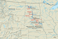
Lake Sakakawea, Garrison Dam, and other dams and reservoirs of the Pick–Sloan Project.
See also
 In Spanish: Lago Sakakawea para niños
