Mercer County, North Dakota facts for kids
Quick facts for kids
Mercer County
|
|
|---|---|

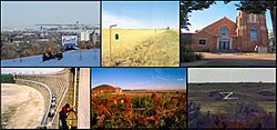
Cities of Mercer, left-to-right, up-to-down; Beulah, Golden Valley, Hazen, Pick City, Stanton, and Zap
|
|

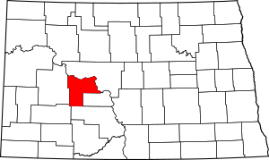
Location within the U.S. state of North Dakota
|
|
 North Dakota's location within the U.S. |
|
| Country | |
| State | |
| Founded | January 14, 1875 (created) November 6, 1883 (organized) |
| Named for | W. H. H. Mercer |
| Seat | Stanton |
| Largest city | Beulah |
| Area | |
| • Total | 1,112 sq mi (2,880 km2) |
| • Land | 1,043 sq mi (2,700 km2) |
| • Water | 70 sq mi (200 km2) 6.3% |
| Population
(2020)
|
|
| • Total | 8,350 |
| • Estimate
(2022)
|
8,333 |
| • Density | 7.509/sq mi (2.8992/km2) |
| Time zone | UTC−6 (Central) |
| • Summer (DST) | UTC−5 (CDT) |
| Congressional district | At-large |
Mercer County is a place in North Dakota, a state in the United States. It's called a county. In 2020, about 8,350 people lived there. The main town, or county seat, where the county government is, is Stanton.
Contents
History of Mercer County
Mercer County was first planned on January 8, 1873. This was when the government of Dakota Territory decided to create it. But this first plan didn't happen.
A new law was made on January 14, 1875, to create Mercer County again. It was named after William Henry Harrison Mercer. He was a rancher who settled near Bismarck in 1869. For a while, the county didn't have its own government. But on November 6, 1883, the county government officially started.
The county's borders changed a few times over the years. They were changed in 1879, 1881, 1885, 1892, and 1901. Since 1901, the borders of Mercer County have stayed the same.
Geography and Nature of Mercer County
The northern edge of Mercer County is along Lake Sakakawea. This big lake was made in 1956 when a dam was built on the Missouri River. The eastern side of the county also follows the Missouri River.
The land in Mercer County has rolling hills. Most of this land is used for farming. The highest point in the county is about 2,451 feet (747 meters) above sea level. This is near the middle of its southern border.
Mercer County covers a total area of about 1,112 square miles (2,880 square kilometers). About 1,043 square miles (2,701 square kilometers) is land. The remaining 70 square miles (181 square kilometers) is water, mostly from the lake and river.
Time Zones in Mercer County
Most of North Dakota uses the Central Time Zone. Before November 7, 2010, part of western Mercer County was in the Mountain Time Zone. But now, all of Mercer County is in the Central Time Zone.
Main Roads in Mercer County
Neighboring Counties
Mercer County shares its borders with several other counties:
- McLean County - to the north
- Oliver County - to the east
- Morton County - to the south
- Stark County - to the southwest
- Dunn County - to the west
Special Protected Areas
Mercer County has some special places that are protected for nature or history:
- Beaver Creek State Game Management Area
- Hazen Bay Recreation Area
- Knife River Indian Villages National Historic Site
- Lake Sakakawea State Park
Major Lake
People and Population in Mercer County
In 2020, the population of Mercer County was 8,350 people. In 2010, there were 8,424 people living there. Most people in the county are white (95.6%). About 2.3% are American Indian.
Many people in Mercer County have German (64.7%) or Norwegian (21.5%) family backgrounds. The average age of people living in the county was about 46.3 years old in 2010.
Towns and Cities in Mercer County
Mercer County has several towns and cities:
Cities
Education in Mercer County
Children in Mercer County attend schools in several different school districts. A school district is a local area that manages public schools.
- Beulah Public School District 27
- Center-Stanton Public School District 1
- Glen Ullin Public School District 48
- Halliday Public School District 19
- Hazen Public School District 3
- Hebron Public School District 13
- Underwood Public School District 8
There is also an elementary school district:
- Twin Buttes Public School District 37
The town of Stanton used to have its own school district. But in 2004, it joined with the Center school district to form Center-Stanton Public School District 1.
Another school district, Riverdale School District 89, used to be partly in Mercer County. In 1993, the people on the school board decided to close it. Its students then went to schools in the Underwood and Hazen districts. The town of Zap also used to have its own school district, but it closed in 1994.
See also
 In Spanish: Condado de Mercer (Dakota del Norte) para niños
 | Jessica Watkins |
 | Robert Henry Lawrence Jr. |
 | Mae Jemison |
 | Sian Proctor |
 | Guion Bluford |


