
Dunn County, North Dakota facts for kids
Quick facts for kids
Dunn County
|
|
|---|---|

Dunn County Courthouse - Manning, North Dakota
|
|

Location within the U.S. state of North Dakota
|
|
 North Dakota's location within the U.S. |
|
| Country | |
| State | |
| Founded | March 9, 1883 (created) January 18, 1908 (organized) |
| Seat | Manning |
| Largest city | Killdeer |
| Area | |
| • Total | 2,082 sq mi (5,390 km2) |
| • Land | 2,008 sq mi (5,200 km2) |
| • Water | 74 sq mi (190 km2) 3.5% |
| Population
(2020)
|
|
| • Total | 4,095 |
| • Estimate
(2022)
|
4,015 |
| • Density | 1.9669/sq mi (0.75941/km2) |
| Time zones | |
| (northern portion) | UTC−6 (Central) |
| • Summer (DST) | UTC−5 (CDT) |
| (southern portion) | UTC−7 (Mountain) |
| • Summer (DST) | UTC−6 (MDT) |
Dunn County is a special area of land in the U.S. state of North Dakota. It's like a big neighborhood with its own local government. In 2020, about 4,095 people lived here. The main town, or county seat, where the county government offices are, is Manning.
Contents
Discovering Dunn County's Past
Dunn County has an interesting history. It was first created on March 9, 1883, by the government of Dakota Territory. This was before North Dakota became a state! The land for Dunn County came from an older area called Howard County.
How Dunn County Was Formed
For a while, Dunn County wasn't fully set up on its own. Its boundaries changed a few times. At one point, in 1896, the government even tried to get rid of Dunn County and make it part of Stark County. But the state's highest court said "no," and Dunn County was brought back!
It took some time, but on January 18, 1908, Dunn County was finally officially organized. This meant it became a standalone county with its own government. It even gained a bit more land from Stark County at that time. The county has stayed the same size ever since.
Who Was John Piatt Dunn?
Dunn County was named after a very important person named John Piatt Dunn. He was a leader in business and the community. He opened the very first drugstore in North Dakota, in the city of Bismarck.
Exploring Dunn County's Landscape
Dunn County is a place of beautiful natural features. The Missouri River flows along its northeastern edge. The Little Missouri River also winds through the middle of the county. It eventually joins the Missouri River.
Hills, Rivers, and Forests
The land in Dunn County has rolling hills. Some parts are dry, like a desert, but with grassy areas. There are also many small valleys and streams that lead to the rivers. The highest point in the county is a hill in the southwest, about 2,625 feet (800 meters) above sea level.
Dunn County covers about 2,082 square miles. Most of this is land, but about 74 square miles are water. It's one of the largest counties in North Dakota!
The Unique Killdeer Mountains
A special part of Dunn County is the Killdeer Mountains. Even though they are called "mountains," they are actually more like tall hills. These hills create a unique natural area. It's a place where you can find more quaking aspen trees and wildlife than in other parts of southwestern North Dakota.
In the northwest corner of the county, you can also find many square miles of bur oak forests. These trees are not common in western North Dakota, making Dunn County quite special.
Main Roads Through the County
- North Dakota Highway 8
- North Dakota Highway 22
- North Dakota Highway 200
.svg)
.svg)
.svg)
Neighboring Counties
Dunn County shares its borders with several other counties:
- Mountrail County (north)
- McLean County (northeast)
- Mercer County (east)
- Stark County (south)
- Billings County (southwest)
- McKenzie County (northwest)
Special Natural Places
Dunn County has protected areas where nature is preserved:
- Lake Ilo National Wildlife Refuge
- Little Missouri Public Use Area
- Kildeer Mountain State Game Preserve
- Badlands Trail Rides
- Little Mountain State Park
Lakes and Waterways
- Moffet Slough
People of Dunn County
| Historical population | |||
|---|---|---|---|
| Census | Pop. | %± | |
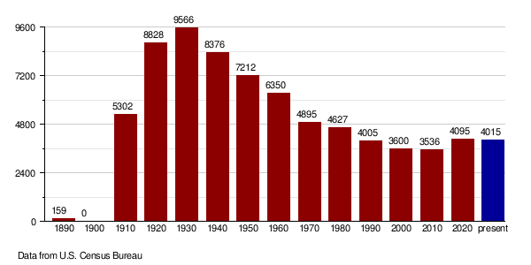
| 1890 | 159 | — | |
| 1910 | 5,302 | — | |
| 1920 | 8,828 | 66.5% | |
| 1930 | 9,566 | 8.4% | |
| 1940 | 8,376 | −12.4% | |
| 1950 | 7,212 | −13.9% | |
| 1960 | 6,350 | −12.0% | |
| 1970 | 4,895 | −22.9% | |
| 1980 | 4,627 | −5.5% | |
| 1990 | 4,005 | −13.4% | |
| 2000 | 3,600 | −10.1% | |
| 2010 | 3,536 | −1.8% | |
| 2020 | 4,095 | 15.8% | |
| 2022 (est.) | 4,015 | 13.5% | |
| U.S. Decennial Census 1790-1960 1900-1990 1990-2000 2010-2020 |
|||
Population Changes Over Time
The number of people living in Dunn County changes over the years. In 2020, there were 4,095 residents.
In 2010, there were 3,536 people. Most people were white (84.9%), and a good number were American Indian (12.7%). Many families living here had children under 18. The average age of people in Dunn County was about 44 years old.
Where People Come From
Many people in Dunn County have family roots from different countries. In 2010, the largest groups were:
How Many People Live Here?
Places to Visit in Dunn County
- Killdeer Mountains
- Killdeer Mountain National Battlefield
Towns and Communities
Dunn County has several towns and smaller communities.
Cities in Dunn County
County Seat
- Manning is the county seat, where the main county offices are.
Other Communities
These are smaller communities that are not officially cities:
- Emerson
- Fayette
- Hirschville
- Marshall
- Medicine Hole
- New Hradec
- Twin Buttes
- Werner
Schools in Dunn County
Students in Dunn County attend schools in various districts.
Schools for All Grades (K-12)
- Beulah Public School District 27
- Dickinson Public School District 1
- Halliday Public School District 19
- Hebron Public School District 13
- Killdeer Public School District 16
- Mandaree Public School District 36
- Richardton-Taylor Public School District 34
- South Heart Public School District 9
Elementary Schools
- Twin Buttes Public School District 37
Images for kids
-
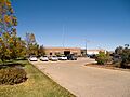
Dunn County Courthouse - Manning, North Dakota
-
North Dakota Highway 8 sign
-
North Dakota Highway 22 sign
-
North Dakota Highway 200 sign
See also
 In Spanish: Condado de Dunn (Dakota del Norte) para niños
