
Mountrail County, North Dakota facts for kids
Quick facts for kids
Mountrail County
|
|
|---|---|

Mountrail County Courthouse in Stanley
|
|

Location within the U.S. state of North Dakota
|
|
 North Dakota's location within the U.S. |
|
| Country | |
| State | |
| Founded | January 4, 1873 1892 (eliminated) January 29, 1909 (reestablished) |
| Seat | Stanley |
| Largest city | New Town |
| Area | |
| • Total | 1,942 sq mi (5,030 km2) |
| • Land | 1,825 sq mi (4,730 km2) |
| • Water | 116 sq mi (300 km2) 6.0% |
| Population
(2020)
|
|
| • Total | 9,809 |
| • Estimate
(2023)
|
9,383 |
| • Density | 5.0510/sq mi (1.9502/km2) |
| Time zone | UTC−6 (Central) |
| • Summer (DST) | UTC−5 (CDT) |
| Congressional district | At-large |
Mountrail County is a place in the northwestern part of North Dakota, United States. It is like a large district within the state. In 2020, about 9,809 people lived here. The main town, or county capital, is Stanley.
Mountrail County was first created in 1873. But then it was removed in 1892 and became part of Ward County. It was brought back and officially set up again in 1909. A big part of the county is home to the Fort Berthold Reservation. This is where the leaders of the Three Affiliated Tribes live.
Contents
History of Mountrail County
The government of Dakota Territory first created Mountrail County on January 4, 1873. It was named "Mountraille County" back then. The name came from Joseph Mountraille. He was a famous Métis voyageur (a traveler who carried goods by canoe) and mail carrier from Pembina. He worked for a fur trader named Norman Kittson.
At first, the county was not officially organized. It was not connected to another county for managing its laws or services. In 1885, some of its land was used to create Garfield County, which no longer exists.
How Mountrail County Was Formed
On February 21, 1891, Mountrail County was linked to Ward County. This was for "judicial and other purposes," meaning for legal and other government needs. However, the next year, on November 8, 1892, the North Dakota government decided to close the county. Its land was then added to Ward County.
But people wanted Mountrail County back! On November 3, 1908, people in Ward County voted to bring Mountrail County back. The vote was close, but the state's highest court said the vote was valid. So, the county government was officially set up again on January 29, 1909. The new county had slightly different borders than before.
Oil and Population Growth
In the early 2000s, a lot of oil was found in the Bakken formation in this area. This brought many workers to Mountrail County. Because of the oil, the number of people living in the county started to grow again. This was a big change after many years of the population getting smaller. From 2010 to 2015, the population grew a lot, which also brought new challenges.

Geography of Mountrail County
The Missouri River flows along the southwest edge of Mountrail County. Shell Creek also flows through the middle part of the county and into the Missouri River. The land here has rolling hills and is mostly used for farming. In the northeast, you can find many small ponds and lakes.
Land and Water Features
A special line called the Laurentian Divide runs east to west through the middle of the county. This means that water in the northern part flows north, and water in the southern part flows south. The highest point in the county is on its western border. It is about 2,480 feet (756 meters) above sea level (ASL).
Mountrail County covers a total area of 1,942 square miles (5,030 square kilometers). Out of this, 1,825 square miles (4,727 square kilometers) is land. The remaining 116 square miles (300 square kilometers), which is about 6% of the total, is water. Mountrail County is one of several counties in western North Dakota that has a lot of the Bakken Formation. This is a rock layer deep underground that contains oil.
Major Roads in Mountrail County
 U.S. Highway 2
 North Dakota Highway 8
 North Dakota Highway 23
 North Dakota Highway 37
 North Dakota Highway 1804
Train Travel
- Amtrak Empire Builder (You can catch this train at the Stanley station)
Neighboring Counties
- Burke County - north
- Ward County - east
- McLean County - southeast
- Dunn County - south
- McKenzie County - southwest
- Williams County - west
Special Natural Areas
- Crow Flies High Butte
- Lostwood National Wildlife Refuge (part)
- Palermo State Game Management Area
- Reunion Point Public Use Area
- Shell Lake National Wildlife Refuge
- Van Hook State Game Management Area
- Van Hook State Wildlife Management Area
Lakes in Mountrail County
- Cottonwood Lake
- Lake Sakakawea
- Powers Lake (part)
- Rat Lake
- Robinson Lake
- Shell Lake
- Van Hook Arm
- White Lake
Population and People
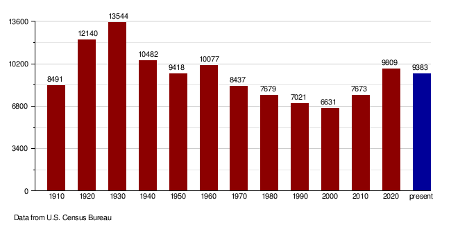
| Historical population | |||
|---|---|---|---|
| Census | Pop. | %± | |
| 1910 | 8,491 | — | |
| 1920 | 12,140 | 43.0% | |
| 1930 | 13,544 | 11.6% | |
| 1940 | 10,482 | −22.6% | |
| 1950 | 9,418 | −10.2% | |
| 1960 | 10,077 | 7.0% | |
| 1970 | 8,437 | −16.3% | |
| 1980 | 7,679 | −9.0% | |
| 1990 | 7,021 | −8.6% | |
| 2000 | 6,631 | −5.6% | |
| 2010 | 7,673 | 15.7% | |
| 2020 | 9,809 | 27.8% | |
| 2023 (est.) | 9,383 | 22.3% | |
| U.S. Decennial Census 1790-1960 1900-1990 1990-2000 2010-2020 |
|||
2020 Population Count
The 2020 census counted 9,809 people living in Mountrail County. There were 3,715 households (groups of people living together) and 2,407 families. The population density was about 5.4 people for every square mile. There were also 5,108 housing units (places where people could live).
2010 Population Count
In the 2010 census, there were 7,673 people in the county. They lived in 2,793 households, and 1,852 of these were families. The population density was about 4.2 people per square mile. There were 4,119 housing units.
Most people in the county were White (65.6%). About 30.6% were Native American. A small number were Black or African American (0.2%) or Asian (0.2%). About 0.8% were from other races, and 2.6% were from two or more races. People of Hispanic or Latino background made up 3.7% of the population.
When it came to where people's families originally came from (their ancestry):
- 36.6% had Norwegian roots.
- 24.4% had German roots.
- 6.6% had Irish roots.
- 0.8% identified as American.
Out of the 2,793 households, 31.1% had children under 18 living with them. About 48.3% were married couples living together. About 11.4% were households where a woman was in charge and there was no husband present. About 33.7% were not families (like single people living alone). And 28.3% of all households were made up of just one person. The average household had 2.55 people, and the average family had 3.11 people. The average age of people in the county was 37.0 years old.
The average income for a household in the county was $53,912. For a family, the average income was $63,238. Men earned an average of $43,386, while women earned an average of $29,432. The average income per person in the county was $25,762. About 13.5% of families and 16.5% of all people lived below the poverty line. This included 24.2% of those under 18 and 14.2% of those aged 65 or older.
Population Changes Over Time
Towns and Communities
Cities in Mountrail County
Smaller Communities
These are smaller places that are not officially cities:
Schools and Education
Here are the school districts that serve students in Mountrail County:
- Kenmare Public School District 28
- Lewis and Clark Public School District 161
- New Town Public School District 1
- Parshall Public School District 3
- Powers Lake Public School District 27
- Stanley Public School District 2
- Tioga Public School District 15
See also
 In Spanish: Condado de Mountrail (Dakota del Norte) para niños
