
Burke County, North Dakota facts for kids
Quick facts for kids
Burke County
|
|
|---|---|

Union Bank of Portal
|
|

Location within the U.S. state of North Dakota
|
|
 North Dakota's location within the U.S. |
|
| Country | |
| State | |
| Founded | 1910 |
| Named for | John Burke |
| Seat | Bowbells |
| Largest city | Powers Lake |
| Area | |
| • Total | 1,129 sq mi (2,920 km2) |
| • Land | 1,104 sq mi (2,860 km2) |
| • Water | 25 sq mi (60 km2) 2.2% |
| Population
(2020)
|
|
| • Total | 2,201 |
| • Estimate
(2022)
|
2,155 |
| • Density | 1.9495/sq mi (0.7527/km2) |
| Time zone | UTC−6 (Central) |
| • Summer (DST) | UTC−5 (CDT) |
| Congressional district | At-large |
Burke County is a county located in the northern part of North Dakota, a state in the United States. It sits right next to the border with Canada. In 2020, about 2,201 people lived there. The main town and county seat is Bowbells. The county was named after John Burke, who was the tenth Governor of North Dakota.
Contents
History
Burke County was officially created on July 12, 1910. Before that, it was part of a larger area called 'Imperial Ward County'. People voted on November 3, 1908, to separate Burke County from this bigger area.
The vote was challenged in court, but the state's highest court decided on June 3, 1910, that the election results were correct. So, Governor John Burke then announced the creation of Burke County. Its government started on July 15, 1910, with Bowbells as its main town. A group of three commissioners manages the county today.
Geography
Burke County is located in northern North Dakota. Its northern border touches the southern border of Canada. Two rivers flow through the county: the Des Lacs River in the east and the White Earth River in the lower part.
The land in Burke County has low hills in the northeast. In the southwest, there are higher, carved ridges. Some of the land is used for farming. The highest point in the county is about 2,461 feet (750 meters) above sea level. The county covers a total area of 1,129 square miles (2,924 square kilometers). Most of this, 1,104 square miles (2,860 square kilometers), is land. The remaining 25 square miles (65 square kilometers) is water.
Major Roads
 U.S. Highway 52
 North Dakota Highway 5
 North Dakota Highway 8
 North Dakota Highway 40
 North Dakota Highway 50
Neighboring Areas
- Estevan No. 5, Saskatchewan – north
- Coalfields No. 4, Saskatchewan – north
- Enniskillen No. 3, Saskatchewan – north
- Renville County – east
- Ward County – southeast
- Mountrail County – south
- Williams County – southwest
- Divide County – west
Nature Preserves
- Des Lacs National Wildlife Refuge (part)
- Lostwood National Wildlife Refuge (part)
Lakes
- Beaver Lake
- Enget Lake
- Iverson Slough
- Powers Lake (part)
- Shallow Lake
- Swensons Slouth
- Teal Slough
- Thompson Slough
- Upper Thompson Lake
Population
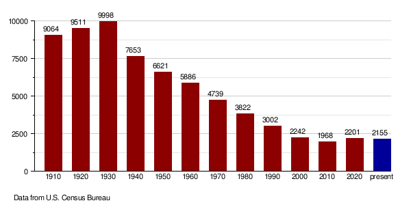
| Historical population | |||
|---|---|---|---|
| Census | Pop. | %± | |
| 1910 | 9,064 | — | |
| 1920 | 9,511 | 4.9% | |
| 1930 | 9,998 | 5.1% | |
| 1940 | 7,653 | −23.5% | |
| 1950 | 6,621 | −13.5% | |
| 1960 | 5,886 | −11.1% | |
| 1970 | 4,739 | −19.5% | |
| 1980 | 3,822 | −19.4% | |
| 1990 | 3,002 | −21.5% | |
| 2000 | 2,242 | −25.3% | |
| 2010 | 1,968 | −12.2% | |
| 2020 | 2,201 | 11.8% | |
| 2022 (est.) | 2,155 | 9.5% | |
| U.S. Decennial Census 1790-1960 1900-1990 1990-2000 2010-2020 |
|||
2020 Census
According to the census in 2020, Burke County had 2,201 people.
2010 Census
In 2010, there were 1,968 people living in Burke County. There were 913 households and 567 families. The population density was about 1.8 people per square mile.
Most people in the county were white (97.8%). A small number were American Indian (0.8%) or Asian (0.7%). About 1.9% of the population was of Hispanic or Latino background. Many people had ancestors from Norway (45.2%), Germany (34.9%), Sweden (13%), and Denmark (10%).
About 22.6% of households had children under 18. The average household had 2.15 people. The average family had 2.74 people. The median age of people in the county was 48.1 years old.
The median income for a household was $50,800. For families, it was $62,283. About 5.8% of the total population lived below the poverty line. This included 9.4% of those under 18.
Population Changes Over Time
Economy
The main ways people make a living in Burke County are through farming and getting oil from the ground. Burke County is known for having a lot of oil in an area called the Bakken Formation. This formation is part of the larger Williston Basin.
Communities
Cities
Other Places
- Larson (a census-designated place)
Small Towns and Areas
- Atcoal
- Battleview
- Coteau
- Kincaid
- Northgate
- Perella
- Rival
- Stampede
- Woburn
Townships
- Battleview
- Bowbells
- Carter
- Clayton
- Cleary
- Colville
- Dale
- Dimond
- Fay
- Foothills
- Forthun
- Garness
- Harmonious
- Kandiyohi
- Keller
- Lakeview
- Leaf Mountain
- Lucy
- Minnesota
- North Star
- Portal
- Richland
- Roseland
- Short Creek
- Soo
- Thorson
- Vale
- Vanville
- Ward
See also
 In Spanish: Condado de Burke (Dakota del Norte) para niños
