
Ward County, North Dakota facts for kids
Quick facts for kids
Ward County
|
|
|---|---|
.jpg)
Ward County Administration Building
|
|

Location within the U.S. state of North Dakota
|
|
 North Dakota's location within the U.S. |
|
| Country | |
| State | |
| Founded | April 14, 1885 (created) November 23, 1885 (organized) |
| Named for | Mark Ward |
| Seat | Minot |
| Largest city | Minot |
| Area | |
| • Total | 2,056 sq mi (5,330 km2) |
| • Land | 2,013 sq mi (5,210 km2) |
| • Water | 43 sq mi (110 km2) 2.1% |
| Population
(2020)
|
|
| • Total | 69,919 |
| • Estimate
(2023)
|
68,332 |
| • Density | 34.007/sq mi (13.130/km2) |
| Time zone | UTC−6 (Central) |
| • Summer (DST) | UTC−5 (CDT) |
| Congressional district | At-large |
Ward County is a place in North Dakota, a state in the United States. In 2020, about 69,919 people lived there. This makes it the fourth most populated county in North Dakota. The main city, called the county seat, is Minot. Ward County is also part of the Minot area, which includes nearby towns and is important for jobs and businesses.
Contents
History of Ward County
How Ward County Was Formed
Ward County was created on April 14, 1885. This happened when the government of Dakota Territory decided to make new counties. They took parts from other areas like Renville, Stevens, and Wynn counties. Stevens and Wynn counties no longer exist today.
The county government officially started on November 23, 1885. Ward County was named after Mark Ward. He was an important person in the House of Representatives at that time.
Changes to County Borders
The first county seat was Burlington. But in 1888, the main city was changed to Minot.
The borders of Ward County changed a few times. This happened in 1887, 1892, 1909, and 1910. The county has had its current borders since 1910.
The 'Imperial Ward' County
Before 1908, Ward County was much bigger. It included areas that are now Burke, Mountrail, and Renville counties. People sometimes called this large area 'Imperial Ward' County. It was the biggest county in North Dakota back then.
In 1908, people voted to split the county into smaller parts. The plan to create Mountrail County was accepted. However, the plans for Burke and Renville counties were argued in court. In 1910, the court decided that these new counties could be formed.
When the new county lines were drawn, neither Burke nor Renville wanted to include Kenmare. They did not want Kenmare to become their county seat. So, Kenmare was left in Ward County. It ended up at the end of a narrow piece of land, which people called the 'gooseneck'. There was even talk of creating a fifth county called Lake, with Kenmare as its main city.
Geography of Ward County
Ward County is located in North Dakota. The Des Lacs River flows through the northeast part of the county. It then turns northeast on its way to Lake Winnipeg. The land in the county has low, rolling hills. There are also many ponds and lakes in the southern part. The land is mostly used for farming.
The land slopes down towards the east and north. The highest point is near the southwest corner. It is about 2,175 feet (663 meters) above sea level. Ward County covers a total area of about 2,056 square miles (5,325 square kilometers). Of this, 2,013 square miles (5,214 square kilometers) is land. The remaining 43 square miles (111 square kilometers) is water. This means about 2.1% of the county is water. It is the fifth-largest county in North Dakota by land area.
Main Roads in Ward County
 U.S. Highway 2
 U.S. Highway 52
 U.S. Highway 83
 North Dakota Highway 5
 North Dakota Highway 23
 North Dakota Highway 28
 North Dakota Highway 50
Public Transportation
- Amtrak Empire Builder (train service at Minot station)
- Minot City Transit (local bus service in Minot)
Neighboring Counties
- Renville County – to the north
- McHenry County – to the east
- McLean County – to the south
- Mountrail County – to the west
- Burke County – to the northwest
Protected Natural Areas
- Des Lacs National Wildlife Refuge (part of it)
- Hiddenwood National Wildlife Refuge (part of it)
- National Wildfowl Production Areas (places for birds)
- Upper Souris National Wildlife Refuge (part of it)
Lakes in Ward County
- Carpenter Lake
- Douglas Lake (part of it)
- Hiddenwood Lake (part of it)
- Makoti Lake
- Rice Lake
- Rush Lake
People of Ward County (Demographics)
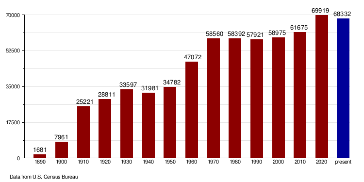
| Historical population | |||
|---|---|---|---|
| Census | Pop. | %± | |
| 1890 | 1,681 | — | |
| 1900 | 7,961 | 373.6% | |
| 1910 | 25,221 | 216.8% | |
| 1920 | 28,811 | 14.2% | |
| 1930 | 33,597 | 16.6% | |
| 1940 | 31,981 | −4.8% | |
| 1950 | 34,782 | 8.8% | |
| 1960 | 47,072 | 35.3% | |
| 1970 | 58,560 | 24.4% | |
| 1980 | 58,392 | −0.3% | |
| 1990 | 57,921 | −0.8% | |
| 2000 | 58,975 | 1.8% | |
| 2010 | 61,675 | 4.6% | |
| 2020 | 69,919 | 13.4% | |
| 2023 (est.) | 68,332 | 10.8% | |
| US Decennial Census 1790–1960 1900–1990 1990-2000 2010-2020 |
|||
Population in 2020
In 2020, the census showed that 69,919 people lived in Ward County. There were 28,847 households (groups of people living together) and 17,323 families. The population density was about 34.7 people per square mile. There were also 32,176 housing units (homes or apartments).
Population in 2010
According to the 2010 census, there were 61,675 people living in the county. There were 25,029 households and 15,597 families. The population density was about 30.6 people per square mile.
Most people in the county were white (90.3%). Other groups included American Indian (2.6%), Black or African American (2.5%), and Asian (0.9%). About 3.0% of the people were of Hispanic or Latino background.
Many people had ancestors from Germany (44.4%) and Norway (30.8%). Other ancestries included Irish (11.6%) and English (5.7%).
The average age of people in Ward County was 32.7 years old. About 30.6% of households had children under 18 living with them.
The median income for a household was $48,793. This means half of the households earned more and half earned less. For families, the median income was $60,361. About 9.4% of all people in the county lived below the poverty line. This included 13.0% of those under 18 years old.
Population Changes Over Time
Towns and Communities in Ward County
Cities
Census-Designated Places (CDPs)
These are areas that are like towns but are not officially incorporated as cities.
Unincorporated Communities
These are small communities that do not have their own local government.
- Aurelia – (a ghost town, meaning it's abandoned)
- Drady
- Gassman – started when a bridge was being built, now called "Trestle Valley"
- Hartland – (another ghost town)
- Hesnault
- Lonetree
- Rice Lake – a community near Rice Lake and Minot
- South Prairie
- Wolseth
Historical Areas
These places were once communities but are now part of larger cities or no longer exist as separate places.
- Harrison – an early community, now part of Minot
- Ralston – a railroad siding (a short track for trains)
- Waldorf – an early community, now part of Minot
Townships
Townships are smaller local government areas within a county.
- Afton
- Anna
- Baden
- Berthold
- Brillian
- Burlington
- Burt
- Cameron
- Carbondale
- Carpio
- Denmark
- Des Lacs
- Elmdale
- Eureka
- Evergreen
- Foxholm
- Freedom
- Gasman
- Greely
- Greenbush
- Harrison
- Hiddenwood
- Hilton
- Iota Flat
- Kenmare
- Kirkelie
- Linton
- Lund
- Mandan
- Margaret
- Maryland
- Mayland
- McKinley
- Nedrose
- New Prairie
- Newman
- Orlien
- Passport
- Ree
- Rice Lake
- Rolling Green
- Rushville
- Ryder
- St. Marys
- Sauk Prairie
- Sawyer
- Shealy
- Spencer
- Spring Lake
- Sundre
- Surrey
- Tatman
- Tolgen
- Torning
- Vang
- Waterford
- Willis
Images for kids
-
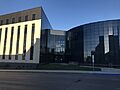
Ward County Administration Building
See also
 In Spanish: Condado de Ward (Dakota del Norte) para niños
