Foxholm, North Dakota facts for kids
Quick facts for kids
Foxholm, North Dakota
|
|
|---|---|

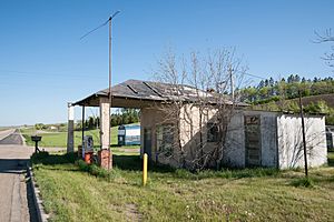
Abandoned Gas Station in Foxholm
|
|
| Country | United States |
| State | North Dakota |
| County | Ward |
| Area | |
| • Total | 0.96 sq mi (2.48 km2) |
| • Land | 0.96 sq mi (2.48 km2) |
| • Water | 0.00 sq mi (0.00 km2) |
| Elevation | 1,677 ft (511 m) |
| Population
(2020)
|
|
| • Total | 56 |
| • Density | 58.39/sq mi (22.54/km2) |
| Time zone | UTC-6 (Central (CST)) |
| • Summer (DST) | UTC-5 (CDT) |
| Area code(s) | 701 |
| GNIS feature ID | 2584343 |
Foxholm is a small community in Ward County, North Dakota, United States. It is known as a census-designated place, which means it's an area that the government counts for population statistics. It is also an unincorporated community, meaning it doesn't have its own local government like a city or town.
Where is Foxholm?
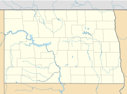
Foxholm is located in the beautiful Des Lacs River Valley. It sits along U.S. Route 52, a major highway. If you travel about 18 miles (29 km) northwest from the city of Minot, you will find Foxholm. It's also about 76 miles (122 km) southeast of the border between North Dakota and Saskatchewan, Canada, near the towns of Portal, ND and North Portal, SK.
A Look at Foxholm's History
The community of Foxholm has a history stretching back to the late 1800s. A post office was first opened here in 1894. This post office served the community for many years, helping people send and receive mail, until it closed in 1967. It is believed that the name "Foxholm" came from a place in England.
Who Lives in Foxholm?
According to the 2020 census, 56 people live in Foxholm. This makes it a very small and quiet community. In 2010, the population was 75 people, showing a slight decrease over the decade.
See also
 In Spanish: Foxholm (Dakota del Norte) para niños
 | DeHart Hubbard |
 | Wilma Rudolph |
 | Jesse Owens |
 | Jackie Joyner-Kersee |
 | Major Taylor |


