
Renville County, North Dakota facts for kids
Quick facts for kids
Renville County
|
|
|---|---|

Renville County Courthouse. Photographed in 1940.
|
|

Location within the U.S. state of North Dakota
|
|
 North Dakota's location within the U.S. |
|
| Country | |
| State | |
| Founded | January 4, 1873 (created) July 20, 1910 (organized) |
| Named for | Joseph Renville |
| Seat | Mohall |
| Largest city | Mohall |
| Area | |
| • Total | 893 sq mi (2,310 km2) |
| • Land | 877 sq mi (2,270 km2) |
| • Water | 16 sq mi (40 km2) 1.8% |
| Population
(2020)
|
|
| • Total | 2,282 |
| • Estimate
(2022)
|
2,220 |
| • Density | 2.5554/sq mi (0.9867/km2) |
| Time zone | UTC−6 (Central) |
| • Summer (DST) | UTC−5 (CDT) |
| Congressional district | At-large |
Renville County is a place in North Dakota, a state in the United States. In 2020, about 2,282 people lived there. The main town, or county seat, is Mohall. Renville County is near the city of Minot. It's also just south of the border with Saskatchewan, a part of Canada.
Contents
History of Renville County
Renville County was first created on January 4, 1873. This happened when the government of Dakota Territory made the decision. The county was named after Joseph Renville. He was an important fur trader and translator. He helped with talks between white settlers and the Sioux people.
At first, the county was not fully set up. Its borders changed a few times. But by 1892, not enough people had moved there. So, Renville County was closed down. Its land became part of Bottineau and Ward counties.
Re-creating the County
Years later, in 1908, people voted to bring Renville County back. This time, it would cover a different area. The vote was very close and went to court. On June 3, 1910, the state's highest court decided the county should be re-created.
The governor officially announced it on July 12, 1910. The county government started working on July 20, 1910. Mohall was chosen as the main town.

Geography and Nature
Renville County is located in northern North Dakota. Its northern border touches Canada. The Souris River flows through the county. This river eventually reaches Hudson Bay. The land here has rolling hills. Most of it is used for farming. The highest point in the county is about 2,005 feet (611 meters) above sea level.
The county covers a total area of 893 square miles (2,313 square kilometers). About 877 square miles (2,271 square kilometers) is land. The remaining 16 square miles (41 square kilometers) is water.
Main Roads
 U.S. Highway 52
 U.S. Highway 83
 North Dakota Highway 5
 North Dakota Highway 28
Neighboring Areas
Renville County shares borders with other counties and areas:
- Mount Pleasant No. 2, Saskatchewan (northwest)
- Argyle No. 1, Saskatchewan (northeast)
- Bottineau County (east)
- McHenry County (southeast)
- Ward County (south)
- Burke County (west)
Protected Natural Areas
- Upper Souris National Wildlife Refuge (part of it is in Renville County)
- Upper Souris Wildlife Refuge
Lakes
- Lake Darling (part of this lake is in the county)
People and Population
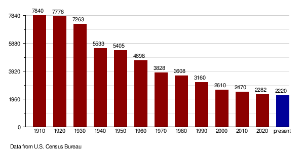
| Historical population | |||
|---|---|---|---|
| Census | Pop. | %± | |
| 1910 | 7,840 | — | |
| 1920 | 7,776 | −0.8% | |
| 1930 | 7,263 | −6.6% | |
| 1940 | 5,533 | −23.8% | |
| 1950 | 5,405 | −2.3% | |
| 1960 | 4,698 | −13.1% | |
| 1970 | 3,828 | −18.5% | |
| 1980 | 3,608 | −5.7% | |
| 1990 | 3,160 | −12.4% | |
| 2000 | 2,610 | −17.4% | |
| 2010 | 2,470 | −5.4% | |
| 2020 | 2,282 | −7.6% | |
| 2022 (est.) | 2,220 | −10.1% | |
| U.S. Decennial Census 1790-1960 1900-1990 1990-2000 2010-2020 |
|||
In 2020, the census counted 2,282 people living in Renville County.
Population Changes Over Time
The number of people living in Renville County has changed over the years. This chart shows the population from 1910 to 2022.
Towns and Communities
Cities in Renville County
Smaller Communities (Unincorporated)
These places are not officially cities or towns.
- Chola
- Greene
- Grover
- Norma
- Rockford
- White Ash
Townships
Townships are smaller local government areas within the county.
- Brandon
- Callahan
- Clay
- Colquhoun
- Eden Valley
- Ensign
- Fairbanks
- Grassland
- Grover
- Hamerly
- Hamlet
- Hurley
- Ivanhoe
- Lockwood
- McKinney
- Muskego
- Plain
- Prescott
- Prosperity
- Rockford
- Roosevelt
- Stafford
- Van Buren
- White Ash
See also
 In Spanish: Condado de Renville (Dakota del Norte) para niños
