Mohall, North Dakota facts for kids
Quick facts for kids
Mohall, North Dakota
|
|
|---|---|
| Motto(s):
Beautiful Town, Beautiful People.
|
|

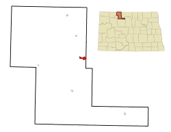
Location of Mohall, North Dakota
|
|
| Country | United States |
| State | North Dakota |
| County | Renville |
| Founded | 1901 |
| Area | |
| • Total | 1.07 sq mi (2.77 km2) |
| • Land | 1.07 sq mi (2.77 km2) |
| • Water | 0.00 sq mi (0.00 km2) |
| Elevation | 1,641 ft (500 m) |
| Population
(2020)
|
|
| • Total | 694 |
| • Estimate
(2022)
|
673 |
| • Density | 649.81/sq mi (250.97/km2) |
| Time zone | UTC-6 (Central (CST)) |
| • Summer (DST) | UTC-5 (CDT) |
| ZIP code |
58761
|
| Area code(s) | 701 |
| FIPS code | 38-53780 |
| GNIS feature ID | 1036167 |
Mohall is a city in North Dakota, a state in the United States. It is the main town, or county seat, of Renville County. In 2020, about 694 people lived there. Mohall is also part of the larger Minot area.
Contents
Mohall's History and Founding
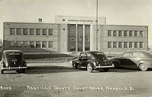
Mohall was started in 1901 by M.O. Hall, a businessman from Duluth, Minnesota. The city was first called Hall. However, there was another town in North Dakota with the same name. So, in 1902, the name was changed to Mohall. In 1910, Mohall became the county seat for Renville County. This means it's where the county government is located. The Renville County Courthouse building opened in 1937.
Mohall's Geography and Location
The city of Mohall covers about 1.08 square miles (2.77 square kilometers) of land. There is no water within the city limits.
Mohall Municipal Airport
The Mohall Municipal Airport is located about one mile west of Mohall. It started operating in December 1944. The city owns and runs this airport. Its coordinates are 48°46′06.2″N 101°32′13.2″W / 48.768389°N 101.537000°W.
Mohall's Population and People
| Historical population | |||
|---|---|---|---|
| Census | Pop. | %± | |
| 1910 | 493 | — | |
| 1920 | 651 | 32.0% | |
| 1930 | 676 | 3.8% | |
| 1940 | 687 | 1.6% | |
| 1950 | 1,073 | 56.2% | |
| 1960 | 956 | −10.9% | |
| 1970 | 950 | −0.6% | |
| 1980 | 1,049 | 10.4% | |
| 1990 | 931 | −11.2% | |
| 2000 | 812 | −12.8% | |
| 2010 | 783 | −3.6% | |
| 2020 | 694 | −11.4% | |
| 2022 (est.) | 673 | −14.0% | |
| U.S. Decennial Census 2020 Census |
|||
Population in 2010
In 2010, there were 783 people living in Mohall. These people lived in 321 households. About 28.7% of households had children under 18. Many households (49.8%) were married couples. The average household had 2.27 people. The average family had 2.90 people.
The average age in Mohall was 44.8 years. About 22.3% of residents were under 18. About 23.5% were 65 years or older. The population was almost evenly split between males (49.7%) and females (50.3%).
Education in Mohall
In 2005, the school districts of Mohall, Sherwood, and Lansford joined together. They formed the Mohall Lansford Sherwood School District. To make everyone happy, they chose a new nickname for the combined schools: the Mavericks. Before this, the Mohall school district's nickname was the Yellowjackets.
Notable Person from Mohall
- Wayne Stenehjem: He was a lawyer. He served as the 29th Attorney General of North Dakota. This means he was the state's chief legal officer.
Mohall's Climate
Mohall has a type of climate called a humid continental climate. This means it has big changes in temperature throughout the year. Summers are warm to hot, and often humid. Winters are very cold. The hottest month is usually August. The coldest month is January. Sometimes, record low temperatures happen in February and March.
| Climate data for Mohall, North Dakota (1991–2020 normals, extremes 1893–present) | |||||||||||||
|---|---|---|---|---|---|---|---|---|---|---|---|---|---|
| Month | Jan | Feb | Mar | Apr | May | Jun | Jul | Aug | Sep | Oct | Nov | Dec | Year |
| Record high °F (°C) | 58 (14) |
64 (18) |
86 (30) |
92 (33) |
107 (42) |
108 (42) |
112 (44) |
107 (42) |
103 (39) |
93 (34) |
77 (25) |
69 (21) |
112 (44) |
| Mean daily maximum °F (°C) | 16.4 (−8.7) |
20.6 (−6.3) |
32.9 (0.5) |
51.2 (10.7) |
64.8 (18.2) |
73.9 (23.3) |
79.1 (26.2) |
79.6 (26.4) |
69.2 (20.7) |
52.8 (11.6) |
34.5 (1.4) |
21.1 (−6.1) |
49.7 (9.8) |
| Daily mean °F (°C) | 7.4 (−13.7) |
10.8 (−11.8) |
22.9 (−5.1) |
38.7 (3.7) |
51.6 (10.9) |
61.8 (16.6) |
66.6 (19.2) |
65.5 (18.6) |
55.6 (13.1) |
41.2 (5.1) |
25.3 (−3.7) |
12.5 (−10.8) |
38.3 (3.5) |
| Mean daily minimum °F (°C) | −1.7 (−18.7) |
1.0 (−17.2) |
12.9 (−10.6) |
26.1 (−3.3) |
38.4 (3.6) |
49.6 (9.8) |
54.0 (12.2) |
51.3 (10.7) |
41.9 (5.5) |
29.6 (−1.3) |
16.1 (−8.8) |
4.0 (−15.6) |
26.9 (−2.8) |
| Record low °F (°C) | −47 (−44) |
−48 (−44) |
−48 (−44) |
−22 (−30) |
8 (−13) |
20 (−7) |
29 (−2) |
21 (−6) |
10 (−12) |
−15 (−26) |
−30 (−34) |
−42 (−41) |
−48 (−44) |
| Average precipitation inches (mm) | 0.43 (11) |
0.47 (12) |
0.73 (19) |
1.13 (29) |
2.51 (64) |
3.76 (96) |
2.62 (67) |
2.24 (57) |
1.70 (43) |
1.33 (34) |
0.75 (19) |
0.55 (14) |
18.22 (463) |
| Source: NOAA | |||||||||||||
See also
 In Spanish: Mohall (Dakota del Norte) para niños
 | Percy Lavon Julian |
 | Katherine Johnson |
 | George Washington Carver |
 | Annie Easley |


