
Bottineau County, North Dakota facts for kids
Quick facts for kids
Bottineau County
|
|
|---|---|

Former U.S. Customs house in Antler
|
|

Location within the U.S. state of North Dakota
|
|
 North Dakota's location within the U.S. |
|
| Country | |
| State | |
| Founded | January 4, 1873 (created) July 17, 1884 (organized) |
| Named for | Pierre Bottineau |
| Seat | Bottineau |
| Largest city | Bottineau |
| Area | |
| • Total | 1,697 sq mi (4,400 km2) |
| • Land | 1,668 sq mi (4,320 km2) |
| • Water | 29 sq mi (80 km2) 1.7% |
| Population
(2020)
|
|
| • Total | 6,379 |
| • Estimate
(2022)
|
6,376 |
| • Density | 3.7590/sq mi (1.4514/km2) |
| Time zone | UTC−6 (Central) |
| • Summer (DST) | UTC−5 (CDT) |
| Congressional district | At-large |
Bottineau County is a county in the state of North Dakota, USA. In 2020, about 6,379 people lived here. The main town, or county seat, is Bottineau.
The county was officially created on January 4, 1873. It was fully set up on July 17, 1884. Bottineau County is named after Pierre Bottineau. He was a Métis pioneer, hunter, and trapper. He later became successful in buying and selling land.
Bottineau County is famous for its winter activities. People enjoy snowmobiling and ice fishing here. It is located just south of the Canadian border, next to Manitoba and Saskatchewan.
Contents
Exploring Bottineau County's Geography
Bottineau County is located in the northern part of North Dakota. Its northern edge touches the border with Canada. The Deep River flows through the middle of the county, heading south. The land here has rolling hills, with many lakes and ponds. The land gently slopes downwards towards the south. The highest point is on the eastern side, about 2,283 feet (696 meters) above sea level. The county covers a total area of 1,697 square miles (4,395 square kilometers). Most of this is land (1,668 sq mi or 4,320 km²), and a small part is water (29 sq mi or 75 km²).
A part of the Turtle Mountain plateau is found in the northeast corner of the county.
Neighboring Areas
Bottineau County shares its borders with several other counties and Canadian areas:
- Argyle No. 1, Saskatchewan (north)
- Municipality of Two Borders, Manitoba (north)
- Municipality of Brenda-Waskada, Manitoba (north)
- Municipality of Deloraine-Winchester, Manitoba (north)
- Boissevain-Morton, Manitoba (north)
- Rolette County (east)
- Pierce County (southeast)
- McHenry County (south)
- Renville County (west)
Main Roads and Highways
These are the major roads that help people travel through Bottineau County:
 U.S. Highway 83
 North Dakota Highway 5
 North Dakota Highway 14
 North Dakota Highway 43
 North Dakota Highway 60
 North Dakota Highway 256
Nature and Parks
Bottineau County has several protected natural areas for wildlife and recreation:
- J. Clark Salyer National Wildlife Refuge (part of it)
- Lake Metigoshe State Park
- Lords Lake National Wildlife Refuge (part of it)
- North Dakota State Forest Service Land
Lakes in the County
Many lakes dot the landscape of Bottineau County:
- Black Lake
- Boundary Lake
- Grass Lake
- Island Lake
- Long Lake
- Loon Lake
- Lords Lake
- Lake Metigoshe
- Pelican Lake
- Strawberry Lake
People of Bottineau County
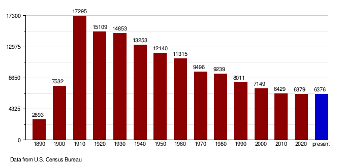
The population of Bottineau County has changed over the years. Here's how it has grown and shrunk:
| Historical population | |||
|---|---|---|---|
| Census | Pop. | %± | |
| 1890 | 2,893 | — | |
| 1900 | 7,532 | 160.4% | |
| 1910 | 17,295 | 129.6% | |
| 1920 | 15,109 | −12.6% | |
| 1930 | 14,853 | −1.7% | |
| 1940 | 13,253 | −10.8% | |
| 1950 | 12,140 | −8.4% | |
| 1960 | 11,315 | −6.8% | |
| 1970 | 9,496 | −16.1% | |
| 1980 | 9,239 | −2.7% | |
| 1990 | 8,011 | −13.3% | |
| 2000 | 7,149 | −10.8% | |
| 2010 | 6,429 | −10.1% | |
| 2020 | 6,379 | −0.8% | |
| 2022 (est.) | 6,376 | −0.8% | |
| U.S. Decennial Census 1790-1960 1900-1990 1990-2000 2010-2020 |
|||
Population Changes Over Time
As of the census in 2020, the county had 6,379 residents.
In 2010, there were 6,429 people living in Bottineau County. This included 2,832 households and 1,823 families. The population density was about 3.9 people per square mile. Most people (95.1%) were white, and 2.1% were American Indian. About 1.3% of the population was of Hispanic or Latino origin. Many residents have roots from Norway (47.0%) and Germany (37.4%).
The average age of people in the county was 48.0 years old.
Population Graph
This graph shows how the population of Bottineau County has changed over the years, based on information from the U.S. Census Bureau.
Towns and Villages
Cities in Bottineau County
These are the cities located within Bottineau County:
Smaller Communities (Unincorporated)
These are other communities in the county that are not officially cities:
Townships
Bottineau County is also divided into many smaller areas called townships:
- Amity
- Antler
- Bentinck
- Blaine
- Brander
- Cecil
- Chatfield
- Cordelia
- Cut Bank
- Dalen
- Eidsvold
- Elms
- Elysian
- Haram
- Hastings
- Hoffman
- Homen
- Kane
- Lansford
- Lewis
- Lordsburg
- Mount Rose
- Newborg
- Oak Creek
- Oak Valley
- Ostby
- Peabody
- Pickering
- Renville
- Richburg
- Roland
- Scandia
- Scotia
- Sergius
- Sherman
- Starbuck
- Stone Creek
- Tacoma
- Wayne
- Wellington
- Wheaton
- Whitby
- Whitteron
- Willow Vale
See also
 In Spanish: Condado de Bottineau para niños
