
Pierce County, North Dakota facts for kids
Quick facts for kids
Pierce County
|
|
|---|---|

|
|

Location within the U.S. state of North Dakota
|
|
 North Dakota's location within the U.S. |
|
| Country | |
| State | |
| Founded | March 11, 1887 (created) April 6, 1889 (organized) |
| Named for | Gilbert A. Pierce |
| Seat | Rugby |
| Largest city | Rugby |
| Area | |
| • Total | 1,082 sq mi (2,800 km2) |
| • Land | 1,019 sq mi (2,640 km2) |
| • Water | 64 sq mi (170 km2) 5.9% |
| Population
(2020)
|
|
| • Total | 3,990 |
| • Estimate
(2022)
|
3,942 |
| • Density | 3.688/sq mi (1.4238/km2) |
| Time zone | UTC−6 (Central) |
| • Summer (DST) | UTC−5 (CDT) |
| Congressional district | At-large |
Pierce County is a county located in the state of North Dakota in the United States. In 2020, about 3,990 people lived there. The main town, or county seat, is Rugby.
Contents
History of Pierce County
Pierce County was officially created on March 11, 1887. It was formed from parts of other counties by the government of the Dakota Territory. The county was named after Gilbert A. Pierce, who was an important political leader in the Dakota Territory.
At first, the county was not fully set up. It was connected to McHenry County for a short time in 1889. But on April 6, 1889, Pierce County started its own government. This meant it could manage its own affairs. Later, on November 8, 1892, the county's size grew when a part of Church County was added to it.
A cool fact about Pierce County is that it's home to the geographical center of North America. This spot is about 6 miles (10 km) west of a town called Balta. In Rugby, you can find a special monument marking this unique location. It is at the crossing of U.S. 2 and N.D. 3.

Geography of Pierce County
Pierce County covers a total area of about 1,082 square miles (2,802 square kilometers). Most of this area, 1,019 square miles (2,639 square kilometers), is land. The remaining 64 square miles (166 square kilometers) is water, which is about 5.9% of the total area.
The land in Pierce County has rolling hills and is mostly used for farming. The North Fork of the Sheyenne River flows through the middle of the county, heading east. The highest point in the county is a hill near its southwest corner. It is about 1,634 feet (498 meters) above sea level.
Major Roads
 U.S. Highway 2
 U.S. Highway 52
 North Dakota Highway 3
 North Dakota Highway 17
 North Dakota Highway 19
 North Dakota Highway 60
Train Services
- Amtrak Empire Builder (Rugby station)
Neighboring Counties
- Rolette County - north
- Towner County - northeast
- Benson County - east
- Wells County - southeast
- Sheridan County - southwest
- McHenry County - west
- Bottineau County - northwest
Protected Natural Areas
- Boyer National Wildlife Refuge
- Buffalo Lake National Wildlife Refuge
- Hurricane Lake National Wildlife Refuge
- Meyer Township National Wildlife Refuge
Lakes in Pierce County
- Antelope Lakes
- Aylmer Lake (part)
- Battema Lake
- Buffalo Lake
- Clear Lake
- Davis Lake
- Girard Lake
- Goose Lake
- Gunderson Lake
- Guss Lake
- Horseshoe Lake
- Kilgore Lake
- Lesmeister Lake
- Long Lake
- Petrified Lake
- Ranch Lake
- Round Lake
- Sand Lake
- Smoky Lake (part)
- Twin Lakes (part)
Population and People
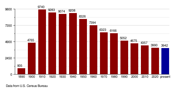
| Historical population | |||
|---|---|---|---|
| Census | Pop. | %± | |
| 1890 | 905 | — | |
| 1900 | 4,765 | 426.5% | |
| 1910 | 9,740 | 104.4% | |
| 1920 | 9,283 | −4.7% | |
| 1930 | 9,074 | −2.3% | |
| 1940 | 9,208 | 1.5% | |
| 1950 | 8,326 | −9.6% | |
| 1960 | 7,394 | −11.2% | |
| 1970 | 6,323 | −14.5% | |
| 1980 | 6,166 | −2.5% | |
| 1990 | 5,052 | −18.1% | |
| 2000 | 4,675 | −7.5% | |
| 2010 | 4,357 | −6.8% | |
| 2020 | 3,990 | −8.4% | |
| 2022 (est.) | 3,942 | −9.5% | |
| U.S. Decennial Census 1790-1960 1900-1990 1990-2000 2010-2020 |
|||
The population of Pierce County has changed over the years. In 1890, there were 905 people. The population grew to its highest in 1910 with 9,740 people. Since then, it has slowly decreased.
2020 Census Information
According to the census in 2020, there were 3,990 people living in Pierce County.
2010 Census Information
In the census of 2010, there were 4,357 people in the county. This included 1,835 households, which are groups of people living together. The population density was about 4.28 people per square mile (1.65 people per square kilometer).
Most people in the county were white (94.1%). About 3.9% were American Indian. People from German backgrounds made up the largest ancestry group (52.3%), followed by Norwegian (34.5%).
The average age of people in Pierce County was 46.9 years. About 24.5% of households had children under 18 living with them. The average income for a household was $37,091. For families, it was $55,304. About 12.9% of all people in the county lived below the poverty line. This included 11.2% of those under 18 years old.
Population Changes Over Time
Communities in Pierce County
Cities
Census-Designated Places (CDPs)
These are areas identified by the Census Bureau for statistical purposes.
Unincorporated Communities
These are places that are not officially organized as cities or towns.
- Leverich
- Silva
- Tunbridge
Townships
Townships are smaller local government areas within the county.
- Alexanter
- Antelope Lake
- Balta
- Elling
- Elverum
- Hagel
- Jefferson
- Meyer
- Ness
- Reno Valley
- Rush Lake
- Torgerson
- Truman
- Tuscarora
- White
Education in Pierce County
Here are the school districts that serve students in Pierce County:
- Anamoose Public School District 14
- Bottineau Public School District 1
- Harvey Public School District 38
- Leeds Public School District 6
- Maddock Public School District 9
- North Star School District
- Rugby Public School District 5
- Towner-Granville-Upham Public School District 60
Former School Districts
- Wolford Public School District 1 - This district closed in 2019.
See also
 In Spanish: Condado de Pierce (Dakota del Norte) para niños
