Wells County, North Dakota facts for kids
Quick facts for kids
Wells County
|
|
|---|---|

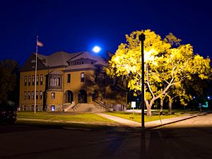
Wells County Courthouse (Fessenden, North Dakota)
|
|

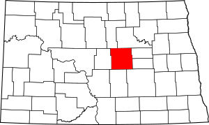
Location within the U.S. state of North Dakota
|
|
 North Dakota's location within the U.S. |
|
| Country | |
| State | |
| Founded | January 4, 1873 (created) August 28, 1884 (organized) |
| Named for | Edward Payson Wells |
| Seat | Fessenden |
| Largest city | Harvey |
| Area | |
| • Total | 1,290 sq mi (3,300 km2) |
| • Land | 1,271 sq mi (3,290 km2) |
| • Water | 19 sq mi (50 km2) 1.5% |
| Population
(2020)
|
|
| • Total | 3,982 |
| • Estimate
(2022)
|
3,930 |
| • Density | 3.087/sq mi (1.192/km2) |
| Time zone | UTC−6 (Central) |
| • Summer (DST) | UTC−5 (CDT) |
| Congressional district | At-large |
Wells County is a county located in the state of North Dakota in the United States. In 2020, about 3,982 people lived here. The main town, or county seat, is Fessenden.
Contents
History of Wells County
Wells County was first created on January 4, 1873, by the government of the Dakota Territory. At first, it was called Gingras County. It didn't have its own local government right away.
On February 26, 1881, the county's name was changed to Wells County. It was named after Edward Payson Wells. He was a banker from Jamestown. He also helped develop the James River Valley area and was a member of the legislature.
The county's government officially started on August 28, 1884. The first county seat was Sykeston. A county seat is the town where the main government offices are located. In 1894, the county seat moved to Fessenden, where it is today.
The county's borders changed a little bit in 1883 and 1885. Since 1885, the borders of Wells County have stayed the same.
An interesting fact is that the "center of population" for all of North Dakota is found in the very southeastern part of Wells County. This is about 9 miles (14 km) southeast of Sykeston.
Geography of Wells County
Wells County covers a total area of 1,290 square miles (3,341 square kilometers). Most of this area, 1,271 square miles (3,292 square kilometers), is land. The remaining 19 square miles (49 square kilometers) is water, which is about 1.5% of the total area.
The James River flows through Wells County, moving from west to east. The land here has rolling hills. You can also find some higher spots and many lakes and ponds, especially in the southwestern part. The land generally slopes downwards towards the east and north. The highest point in the county is about 2,182 feet (665 meters) above sea level (ASL). This high spot is near the southwestern corner of the county.
Main Roads in Wells County
These are the important highways that go through Wells County:
Counties Next to Wells County
Wells County shares its borders with several other counties:
- Benson County - to the north
- Eddy County - to the east
- Foster County - also to the east
- Stutsman County - to the southeast
- Kidder County - to the south
- Sheridan County - to the west
- Pierce County - to the northwest
Protected Natural Areas
Wells County has special areas set aside to protect nature:
- Karl T. Frederick State Game Management Area
- Upland State Game Refuge
Lakes in Wells County
Here are some of the lakes you can find in Wells County:
- Big Slough
- Crystal Lake
- Egg Lake
- Lake Ontario
- Silver Lake
- Sorenson Lake
People of Wells County (Demographics)
The number of people living in Wells County has changed over time. In 1890, there were 1,212 people. The population grew a lot in the early 1900s, reaching its highest point of 13,285 people in 1930. Since then, the population has slowly decreased. In 2020, the population was 3,982.
2020 Census Information
According to the census taken in 2020, there were 3,982 people living in Wells County.
2010 Census Information
In 2010, the census showed that 4,207 people lived in Wells County. There were 1,943 households and 1,223 families. A household is a group of people living together, and a family is a group related by blood, marriage, or adoption.
The population density was about 3.31 people per square mile (1.28 people per square kilometer). This means there weren't many people living in each square mile of land. There were also 2,481 housing units, which are places where people can live.
Most of the people in Wells County were white (98.9%). A small number were American Indian (0.3%), black or African American (0.1%), or Asian (0.1%). About 0.6% of people were from two or more races. People of Hispanic or Latino origin made up 0.5% of the population.
When it came to where people's families originally came from (their ancestry), many had German roots (65.9%). Others had Norwegian (25.9%), Irish (6.7%), or American (1.8%) ancestry.
About 19.7% of households had children under 18 living with them. More than half (54.1%) were married couples living together. About 37.1% of households were not families, meaning they were individuals living alone or unrelated people living together. The average household had 2.10 people, and the average family had 2.67 people. The average age of people in the county was 51.5 years old.
The median income for a household in the county was $40,136. This means half of the households earned more than this amount, and half earned less. For families, the median income was $52,400. Men earned about $38,442 on average, while women earned about $25,597. The average income per person in the county was $23,531.
About 6.1% of families and 10.3% of all people in Wells County lived below the poverty line. This included 12.5% of children under 18 and 17.1% of people aged 65 or older.
Communities in Wells County
Wells County has several towns and smaller communities.
Cities in Wells County
Census-Designated Place
- Heimdal (This is a community that is like a town but doesn't have its own local government.)
Unincorporated Communities
These are smaller communities that are not officially organized as cities or towns:
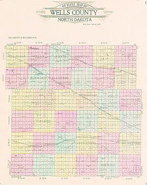
Townships in Wells County
Townships are smaller areas of land within a county, often with their own local government or administration:
- Berlin
- Bilodeau
- Bremen
- Bull Moose
- Cathay
- Chaseley
- Crystal Lake
- Delger
- Fairville
- Forward
- Fram
- Germantown
- Haaland
- Hamburg
- Hawksnest
- Heimdal
- Hillsdale
- Johnson
- Lynn
- Manfred
- Norway Lake
- Oshkosh
- Pony Gulch
- Progress
- Rusland
- Saint Anna
- Silver Lake
- South Cottonwood
- Speedwell
- Sykeston
- Valhalla
- Wells
- West Norway
- West Ontario
- Western
- Woodward
See also
 In Spanish: Condado de Wells (Dakota del Norte) para niños
 | Bessie Coleman |
 | Spann Watson |
 | Jill E. Brown |
 | Sherman W. White |


