
Eddy County, North Dakota facts for kids
Quick facts for kids
Eddy County
|
|
|---|---|

Eddy County Courthouse
|
|

Location within the U.S. state of North Dakota
|
|
 North Dakota's location within the U.S. |
|
| Country | |
| State | |
| Founded | 1885 |
| Seat | New Rockford |
| Largest city | New Rockford |
| Area | |
| • Total | 644 sq mi (1,670 km2) |
| • Land | 630 sq mi (1,600 km2) |
| • Water | 14 sq mi (40 km2) 2.2% |
| Population
(2020)
|
|
| • Total | 2,347 |
| • Estimate
(2022)
|
2,314 |
| • Density | 3.644/sq mi (1.4071/km2) |
| Time zone | UTC−6 (Central) |
| • Summer (DST) | UTC−5 (CDT) |
| Congressional district | At-large |
| Website | Eddy County, North Dakota |
Eddy County is a county in the state of North Dakota, United States. In 2020, about 2,347 people lived there. The main town and county seat is New Rockford.
Contents
History of Eddy County
The government of Dakota Territory created Eddy County on March 31, 1885. It was formed from a part of Foster County. The county was named after Ezra B. Eddy, a banker from Fargo, North Dakota. He had passed away just a few weeks before the county was formed. The county government officially started on April 27, 1885.
Geography of Eddy County
The Sheyenne River flows east through the northern part of Eddy County. The land in the county has rolling hills and some areas used for farming. The land slopes gently towards the east and slightly north. The highest point is a hill in the county's southwest corner. It is about 1,562 feet (476 meters) above sea level.
Eddy County covers a total area of 644 square miles. About 630 square miles of this is land, and 14 square miles (2.2%) is water. It is the smallest county in North Dakota by land area.
Neighboring Counties
Eddy County shares borders with several other counties:
- Benson County to the north
- Nelson County to the northeast
- Griggs County to the southeast
- Foster County to the south
- Wells County to the west
Main Roads and Highways
These are the most important roads that go through Eddy County:
 U.S. Highway 281
 North Dakota Highway 15
 North Dakota Highway 20
Local County Roads
- Eddy County Road 1
- Eddy County Road 2
- Eddy County Road 3
- Eddy County Road 4
- Eddy County Road 5
- Eddy County Road 6
- Eddy County Road 7
- Eddy County Road 8
- Eddy County Road 9
- Eddy County Road 10
- Eddy County Road 12
- Eddy County Road 14
- Eddy County Road 16
Eddy County Road 14 runs north and south. It connects North Dakota Highway 15 near New Rockford to Eddy County Road 9 in downtown New Rockford. Eddy County Road 9 runs east and west. It connects US 281/Highway 15 in New Rockford to Wells County CR 2.
Protected Natural Areas
Part of the Johnson Lake National Wildlife Refuge is located in Eddy County. This area helps protect wildlife and their habitats.
People and Population (Demographics)
| Historical population | |||
|---|---|---|---|
| Census | Pop. | %± | |
| 1890 | 1,377 | — | |
| 1900 | 3,330 | 141.8% | |
| 1910 | 4,800 | 44.1% | |
| 1920 | 6,493 | 35.3% | |
| 1930 | 6,346 | −2.3% | |
| 1940 | 5,741 | −9.5% | |
| 1950 | 5,372 | −6.4% | |
| 1960 | 4,936 | −8.1% | |
| 1970 | 4,103 | −16.9% | |
| 1980 | 3,554 | −13.4% | |
| 1990 | 2,951 | −17.0% | |
| 2000 | 2,757 | −6.6% | |
| 2010 | 2,385 | −13.5% | |
| 2020 | 2,347 | −1.6% | |
| 2022 (est.) | 2,314 | −3.0% | |
| U.S. Decennial Census 1790-1960 1900-1990 1990-2000 2010-2020 |
|||
2020 Census Information
A census is an official count of the population. As of the 2020 census, there were 2,347 people living in Eddy County.
2010 Census Information
In the 2010 census, Eddy County had 2,385 people. There were 1,057 households and 653 families. The population density was about 3.8 people per square mile.
Most people in the county were white (95.2%). About 2.4% were American Indian. People from other backgrounds also lived there. Many residents had German (52.7%) or Norwegian (45.9%) ancestry.
The average household had 2.18 people. The average family had 2.77 people. The median age of people in the county was 49.2 years old.
The median income for a household was $38,404. For families, it was $47,857. About 15.4% of all people in the county lived below the poverty line. This included 21.0% of those under 18.
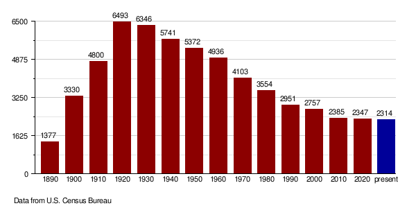
Population Changes Over Time
The chart below shows how the population of Eddy County has changed over many years. You can see how the number of people living there has gone up and down.
Towns and Communities
Cities in Eddy County
- New Rockford (This is the county seat, meaning it's the main administrative town.)
- Sheyenne
Smaller Unincorporated Communities
These are smaller places that are not officially organized as cities:
- Brantford
- Hamar
Townships in Eddy County
Townships are smaller local government areas within the county:
- Bush
- Cherry Lake
- Columbia
- Colvin
- Eddy
- Freeborn
- Gates
- Grandfield
- Hillsdale
- Lake Washington
- Munster
- New Rockford
- Paradise
- Pleasant Prairie
- Rosefield
- Sheldon
- Superior
- Tiffany
See also
 In Spanish: Condado de Eddy (Dakota del Norte) para niños
