
Griggs County, North Dakota facts for kids
Quick facts for kids
Griggs County
|
|
|---|---|
.jpg)
Griggs County Courthouse. Photographed in 1892.
|
|

Location within the U.S. state of North Dakota
|
|
 North Dakota's location within the U.S. |
|
| Country | |
| State | |
| Founded | February 18, 1881 (created) June 16, 1882 (organized) |
| Named for | Alexander Griggs |
| Seat | Cooperstown |
| Largest city | Cooperstown |
| Area | |
| • Total | 716 sq mi (1,850 km2) |
| • Land | 709 sq mi (1,840 km2) |
| • Water | 7.6 sq mi (20 km2) 1.1% |
| Population
(2020)
|
|
| • Total | 2,306 |
| • Estimate
(2022)
|
2,252 |
| • Density | 3.2207/sq mi (1.2435/km2) |
| Time zone | UTC−6 (Central) |
| • Summer (DST) | UTC−5 (CDT) |
| Congressional district | At-large |
Griggs County is a county located in North Dakota, a state in the United States. In 2020, about 2,306 people lived here. The main town and county seat of Griggs County is Cooperstown.
Contents
History of Griggs County
Griggs County was first created on February 18, 1881. This happened when the government of Dakota Territory decided to use parts of Barnes, Foster, and Traill counties to form it.
The county is named after Alexander Griggs. He was a steamboat captain who helped start the city of Grand Forks.
Griggs County officially began operating on June 16, 1882. A small change was made to its border in 1883 when Steele County was formed. Since then, the county's shape has stayed the same.
A special place in Griggs County is the Conrad and Sylvia Fogderud farm. It's sometimes called "Little Tornado Alley" because many tornadoes have happened there over the years.

Geography and Nature
Griggs County covers about 716 square miles. Most of this area, 709 square miles, is land. The rest, about 7.6 square miles, is water. This makes it one of the smaller counties in North Dakota.
The Sheyenne River flows through the eastern part of the county. It eventually empties into Lake Ashtabula in the southeast corner. The land in the county has gentle hills and many small lakes and ponds. Most of the land is used for farming. The highest point in Griggs County is a hill in the northwest, which is about 1,562 feet high.
Main Roads in Griggs County
 North Dakota Highway 1
 North Dakota Highway 45
 North Dakota Highway 65
 North Dakota Highway 200
Neighboring Counties
- Nelson County (to the north)
- Steele County (to the east)
- Barnes County (to the south)
- Stutsman County (to the southwest)
- Foster County (to the west)
- Eddy County (to the northwest)
Protected Natural Areas
- Sibley Lake National Wildlife Refuge is a special area in Griggs County. It helps protect wildlife and their homes.
Lakes in Griggs County
Griggs County has many lakes and ponds. Some of them include:
- Hoot-E-Too Lake
- Jones Lake
- Lake Addie
- Lake Ashtabula (partly in this county)
- Lake Five
- Lake Jessie
- Lake Norway
- Lake Silver
- Long Lake
- Phelps Lake
- Pickerel Lake (partly in this county)
- Plum Lake
- Red Willow Lake
- Round Lake
- Rush Lake
- Sibley Lake
People and Population
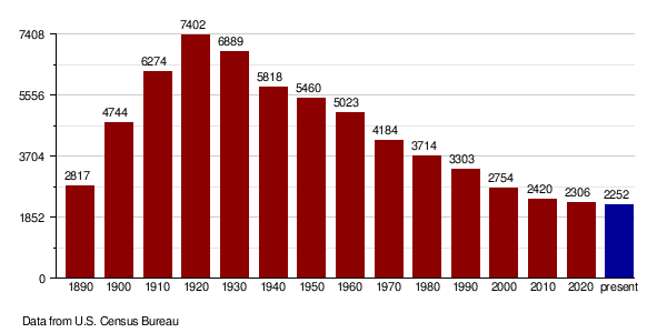
| Historical population | |||
|---|---|---|---|
| Census | Pop. | %± | |
| 1890 | 2,817 | — | |
| 1900 | 4,744 | 68.4% | |
| 1910 | 6,274 | 32.3% | |
| 1920 | 7,402 | 18.0% | |
| 1930 | 6,889 | −6.9% | |
| 1940 | 5,818 | −15.5% | |
| 1950 | 5,460 | −6.2% | |
| 1960 | 5,023 | −8.0% | |
| 1970 | 4,184 | −16.7% | |
| 1980 | 3,714 | −11.2% | |
| 1990 | 3,303 | −11.1% | |
| 2000 | 2,754 | −16.6% | |
| 2010 | 2,420 | −12.1% | |
| 2020 | 2,306 | −4.7% | |
| 2022 (est.) | 2,252 | −6.9% | |
| U.S. Decennial Census 1790-1960 1900-1990 1990-2000 2010-2020 |
|||
In 2020, the census showed that 2,306 people lived in Griggs County.
Population Details from 2010
According to the 2010 census, there were 2,420 people living in Griggs County. There were 1,131 households and 694 families. The population density was about 3.4 people per square mile.
Most people in the county (98.8%) were white. A small number were American Indian (0.3%), Black (0.3%), or Asian (0.2%). About 0.4% of the population was of Hispanic or Latino background.
Many people in Griggs County have Norwegian (60.8%) or German (36.7%) family backgrounds. Other ancestries include English (5.9%) and Swedish (5.6%).
The average age of people in Griggs County was 51.9 years old. About 20.8% of households had children under 18 living with them.
Population Changes Over Time
Towns and Areas
Griggs County has several communities, from small cities to tiny unincorporated places.
Cities in Griggs County
- Binford
- Cooperstown (This is the main town, also called the county seat)
- Hannaford
Special Census Areas
These are places that are like towns but are not officially incorporated as cities:
Small Unincorporated Communities
These are even smaller places that do not have their own local government:
- Karnak
- Walum
- Mose
Townships in Griggs County
A township is a small local area, often with its own government. Griggs County has many townships:
- Addie
- Ball Hill
- Bartley
- Broadview
- Bryan
- Clearfield
- Cooperstown
- Dover
- Greenfield
- Helena
- Kingsley
- Lenora
- Mabel
- Pilot Mound
- Romness
- Rosendal
- Sverdrup
- Tyrol
- Washburn
- Willow
| Range 61 | Range 60 | Range 59 | Range 58 | |
|---|---|---|---|---|
| Township 148 | Rosendal | Willow | Pilot Mound | Lenora |
| Township 147 | Bryan | Addie | Tyrol | Romness |
| Township 146 | Kingsley | Clearfield | Cooperstown | Washburn |
| Township 145 | Mabel | Helena | Ball Hill | Sverdrup |
| Township 144 | Dover | Bartley | Greenfield | Broadview |
Education in Griggs County
Students in Griggs County attend schools in several different school districts:
- Barnes County North Public School District 7
- Dakota Prairie Public School District 1
- Finley-Sharon Public School District 19
- Griggs County Central School District 18
- Hope-Page School District
- Midkota Public School District 7
See also
 In Spanish: Condado de Griggs para niños
