
Nelson County, North Dakota facts for kids
Quick facts for kids
Nelson County
|
|
|---|---|

Water Tower behind Lakota City Hall.
|
|

Location within the U.S. state of North Dakota
|
|
 North Dakota's location within the U.S. |
|
| Country | |
| State | |
| Founded | March 2, 1883 (created) June 9, 1883 (organized) |
| Seat | Lakota |
| Largest city | Lakota |
| Area | |
| • Total | 1,009 sq mi (2,610 km2) |
| • Land | 982 sq mi (2,540 km2) |
| • Water | 27 sq mi (70 km2) 2.7% |
| Population
(2020)
|
|
| • Total | 3,015 |
| • Estimate
(2022)
|
2,995 |
| • Density | 2.9881/sq mi (1.1537/km2) |
| Time zone | UTC−6 (Central) |
| • Summer (DST) | UTC−5 (CDT) |
| Congressional district | At-large |
Nelson County is a county in the state of North Dakota, USA. In 2020, about 3,015 people lived there. The main town and county seat is Lakota.
Contents
History of Nelson County
Nelson County was officially created on March 2, 1883. This happened when the government of the Dakota Territory decided to set up new areas. Parts of other counties like Foster, Grand Forks, and Ramsey were used to form Nelson County.
At first, Nelson County was not fully set up with its own government. It was managed by Grand Forks County. But on June 9, 1883, Nelson County became fully organized. This meant it got its own local government and could manage its own affairs.
Geography of Nelson County
Nelson County has rolling hills and many small lakes and ponds. Most of the land is used for farming. The land gently slopes towards the south and east. The highest point in the county is about 1,545 feet (471 meters) above sea level. This spot is near the middle of its northern border.
The county covers a total area of 1,009 square miles (2,613 square kilometers). About 982 square miles (2,543 square kilometers) of this is land. The remaining 27 square miles (70 square kilometers) is water, which is about 2.7% of the total area.
Main Roads in Nelson County
 U.S. Highway 2
 North Dakota Highway 1
 North Dakota Highway 15
 North Dakota Highway 32
 North Dakota Highway 35
Neighboring Counties
Nelson County shares borders with several other counties:
- Walsh County - to the northeast
- Grand Forks County - to the east
- Steele County - to the southeast
- Griggs County - to the south
- Eddy County - to the southwest
- Benson County - to the west
- Ramsey County - to the northwest
Protected Natural Areas
These are special places in Nelson County that protect wildlife and nature:
- Johnson Lake National Wildlife Refuge (part of it)
- Lambs Lake National Wildlife Refuge
- Rose Lake National Wildlife Refuge
- Stump Lake National Wildlife Refuge
Lakes in Nelson County
Here are some of the lakes you can find in Nelson County:
- Bitter Lake
- Church Lake
- Hillesland Lake
- Johnson Lake
- Lake Laretta
- Mannie Lake
- Omild Slough
- Ottofy Lake
- Rose Lake
- Rugh Lake
- Stump Lake
- Swan Lake
People of Nelson County (Demographics)
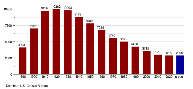
| Historical population | |||
|---|---|---|---|
| Census | Pop. | %± | |
| 1890 | 4,293 | — | |
| 1900 | 7,316 | 70.4% | |
| 1910 | 10,140 | 38.6% | |
| 1920 | 10,362 | 2.2% | |
| 1930 | 10,203 | −1.5% | |
| 1940 | 9,129 | −10.5% | |
| 1950 | 8,090 | −11.4% | |
| 1960 | 7,034 | −13.1% | |
| 1970 | 5,776 | −17.9% | |
| 1980 | 5,233 | −9.4% | |
| 1990 | 4,410 | −15.7% | |
| 2000 | 3,715 | −15.8% | |
| 2010 | 3,126 | −15.9% | |
| 2020 | 3,015 | −3.6% | |
| 2022 (est.) | 2,995 | −4.2% | |
| U.S. Decennial Census 1790-1960 1900-1990 1990-2000 2010-2020 |
|||
Population in 2020
According to the 2020 census, there were 3,015 people living in Nelson County.
Population in 2010
In 2010, there were 3,126 people in the county. Most of the people (97.2%) were white. About 1.0% were Native American.
Many people in Nelson County have Norwegian (52.3%) or German (34.1%) backgrounds.
How the Population Has Changed
Towns and Communities
Cities in Nelson County
- Aneta
- Lakota (This is the county seat, where the main government offices are)
- McVille
- Michigan City
- Pekin
- Petersburg
- Tolna
Special Community (CDP)
- Dahlen is a Census-designated place (CDP). This means it's a community that the U.S. Census Bureau identifies for statistics, but it's not an officially incorporated city or town.
Other Small Communities
These are places that are not officially organized as cities or towns:
Townships in Nelson County
Townships are smaller local government areas within a county. Here are the townships in Nelson County:
- Adler
- Bergen
- Central
- Clara
- Dahlen
- Dayton
- Dodds
- Enterprise
- Field
- Forde
- Hamlin
- Illinois
- Lakota
- Lee
- Leval
- Melvin
- Michigan
- Nash
- Nesheim
- Ora
- Osago
- Petersburg
- Rubin
- Rugh
- Sarnia
- Wamduska
- Williams
See also
 In Spanish: Condado de Nelson (Dakota del Norte) para niños
