
Ramsey County, North Dakota facts for kids
Quick facts for kids
Ramsey County
|
|
|---|---|

Ramsey County Courthouse in Devils Lake, North Dakota.
|
|

Location within the U.S. state of North Dakota
|
|
 North Dakota's location within the U.S. |
|
| Country | |
| State | |
| Founded | January 4, 1873 (created) January 25, 1883 (organized) |
| Named for | Alexander Ramsey |
| Seat | Devils Lake |
| Largest city | Devils Lake |
| Area | |
| • Total | 1,301 sq mi (3,370 km2) |
| • Land | 1,187 sq mi (3,070 km2) |
| • Water | 114 sq mi (300 km2) 8.8% |
| Population
(2020)
|
|
| • Total | 11,605 |
| • Estimate
(2023)
|
11,463 |
| • Density | 8.920/sq mi (3.4441/km2) |
| Time zone | UTC−6 (Central) |
| • Summer (DST) | UTC−5 (CDT) |
| Congressional district | At-large |
Ramsey County is a county located in the state of North Dakota in the United States. In 2020, about 11,605 people lived there. The main city and county seat (where the county government is) is Devils Lake.
Contents
History of Ramsey County
The county was first created on January 4, 1873, by the government of the Dakota Territory. It was formed from parts of Pembina County.
Ramsey County was named after Alexander Ramsey. He was a U.S. Senator from Minnesota and the very first governor of the Minnesota Territory.
At first, the county government wasn't fully set up. It wasn't until January 25, 1883, that the county officially started its government operations. The county's borders changed a few times in the 1880s, but they have stayed the same since 1890.

Geography and Nature
Ramsey County is located in North Dakota. Its southwest edge touches Devils Lake, a large lake. The land here has rolling hills and many small lakes and ponds. Most of the land is used for farming.
The highest point in the county is in the northeast corner. It is about 1,631 feet (497 meters) above sea level. The county covers a total area of about 1,301 square miles (3,370 square kilometers). About 114 square miles (295 square kilometers) of this area is water, which is about 8.8% of the total.

Main Roads in Ramsey County
 U.S. Highway 2
 U.S. Highway 281
 North Dakota Highway 1
 North Dakota Highway 17
 North Dakota Highway 19
 North Dakota Highway 20
 North Dakota Highway 57
Train Travel
- Amtrak's Empire Builder train stops at the Devils Lake station.
Neighboring Counties
- Cavalier County - to the north
- Walsh County - to the east
- Nelson County - to the southeast
- Benson County - to the southwest
- Towner County - to the northwest
Protected Natural Areas
- Lake Alice National Wildlife Refuge (part of it is in Ramsey County)
- Silver Lake National Wildlife Refuge (part of it is in Ramsey County)
Lakes in Ramsey County
- Chain Lake
- Creel Bay
- Dry Lake
- East Devils Lake
- Lake Alice
- Lake Irvine
- Mikes Lake
- Morrison Lake
- Sixmile Bay
- Sweetwater Lake
Population and People
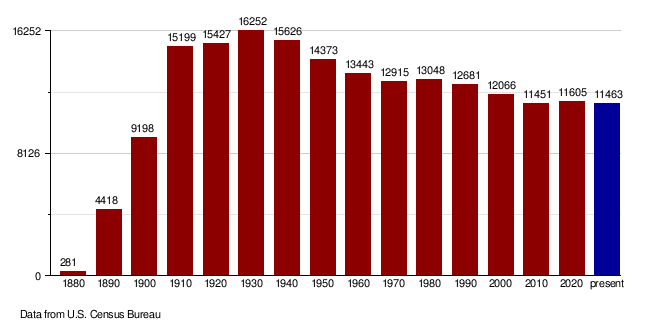
| Historical population | |||
|---|---|---|---|
| Census | Pop. | %± | |
| 1880 | 281 | — | |
| 1890 | 4,418 | 1,472.2% | |
| 1900 | 9,198 | 108.2% | |
| 1910 | 15,199 | 65.2% | |
| 1920 | 15,427 | 1.5% | |
| 1930 | 16,252 | 5.3% | |
| 1940 | 15,626 | −3.9% | |
| 1950 | 14,373 | −8.0% | |
| 1960 | 13,443 | −6.5% | |
| 1970 | 12,915 | −3.9% | |
| 1980 | 13,048 | 1.0% | |
| 1990 | 12,681 | −2.8% | |
| 2000 | 12,066 | −4.8% | |
| 2010 | 11,451 | −5.1% | |
| 2020 | 11,605 | 1.3% | |
| 2023 (est.) | 11,463 | 0.1% | |
| U.S. Decennial Census 1790-1960 1900-1990 1990-2000 2010-2020 |
|||
How Many People Live Here?
In 2020, the census counted 11,605 people living in Ramsey County. There were 4,947 households and 2,883 families. The county had about 9.8 people per square mile (3.8 people per square kilometer). There were also 5,843 homes available.
In 2010, there were 11,451 people. Most people were white (87.7%), and 8.7% were Native American. People from German and Norwegian backgrounds were the largest groups.
Population Changes Over Time
Towns and Communities
Cities in Ramsey County
- Brocket
- Crary
- Devils Lake (This is the county seat)
- Edmore
- Hampden
- Lawton
- Starkweather
Other Communities
These are smaller places that are not officially cities:
Townships
Townships are smaller areas within the county, often with their own local government:
- Bartlett
- Cato
- Chain Lakes
- Coulee
- Creel
- De Groat
- Dry Lake
- Fancher
- Freshwater
- Grand Harbor
- Hammer
- Harding
- Highland Center
- Hope
- Klingstrup
- Lawton
- Lillehoff
- Minnewaukan
- Morris
- Newbre
- Newland
- Noonan
- North Creel
- Northfield
- Odessa
- Ontario
- Overland
- Pelican
- Poplar Grove
- Prospect
- Royal
- South Minnewaukan
- Stevens
- Sullivan
- Triumph
- Webster
Education
Here are the school districts that serve students in Ramsey County:
- Dakota Prairie Public School District 1
- Devils Lake Public School District 1
- Edmore Public School District 2
- Lakota Public School District 66
- Leeds Public School District 6
- Minnewaukan Public School District 5
- North Star School District
- Starkweather Public School District 44
- Warwick Public School District 29
See also
 In Spanish: Condado de Ramsey (Dakota del Norte) para niños
