Devils Lake (North Dakota) facts for kids
Quick facts for kids Devils Lake |
|
|---|---|
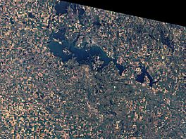
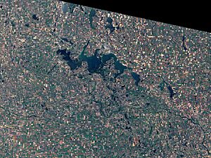
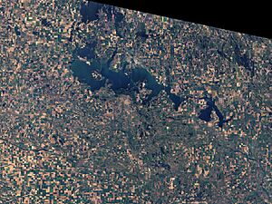
View from space (March 2009)
|
|
| Location | Ramsey / Benson counties, North Dakota, U.S. |
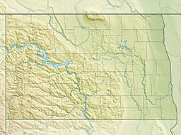
| Coordinates | 48°2′5″N 98°56′39″W / 48.03472°N 98.94417°W |
| Lake type | Endorheic basin Potentially an open lake owing to climate change |
| Catchment area | 3,810 sq mi (9,900 km2) |
| Basin countries | United States |
| Max. depth | more than 59 feet (18 m) |
| Surface elevation | 1,454.20 ft (443.24 m) |
| Settlements | Devils Lake, Minnewaukan |
Devils Lake is a large lake in North Dakota, United States. It is the biggest natural lake in the state. Only Lake Sakakawea, which is man-made, is larger.
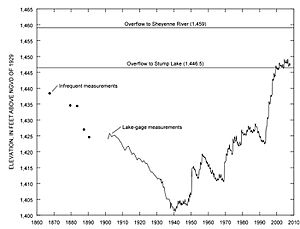
The lake can get as high as 1,458 ft (444 m) above sea level. If it reaches this level, its water would naturally flow into the Sheyenne River. On June 27, 2011, the lake reached a very high level of 1,454.3 ft (443.3 m).
The cities of Devils Lake and Minnewaukan are named after the lake. The Spirit Lake Reservation is also located on the lake's southern side.
Contents
History of Devils Lake
The area around Devils Lake has long been the home of the Dakota people. The Dakota people consider the lake to be a special place. They believe it is the home of a water spirit or serpent called Unktehi.
The Dakota name for the lake is mni wak’áŋ. This means "pure source" or "spirit water." The nearby town of Minnewaukan and the Spirit Lake Tribe get their names from this Dakota word.
When European settlers arrived, they misunderstood the name. They thought "spirit" meant "bad spirit" or "devil." This is because the lake water is salty and not good to drink. Also, people often saw mirages (optical illusions) across the water. So, they called it "Devils Lake." The idea of a "devil" is not part of the Dakota people's beliefs.
Other Native American groups, like the Mandan, Hidatsa, and Arikara Nations, also used the lake.
Where is Devils Lake?
Devils Lake is in northeastern North Dakota. It is located in Ramsey County and Benson County.
The Spirit Lake Tribe lives along most of the southern shore of the lake. They have been greatly affected by the lake's rising water levels since the 1990s.
How Devils Lake Works
Devils Lake is a "closed lake" or endorheic lake. This means water flows into it, but it doesn't have a natural river flowing out. The water leaves mostly by evaporating into the air.
The lake collects water from a large area of about 3,800 sq mi (9,800 km2). If the lake's water level goes above 1,447 ft (441 m), it can spill into a nearby lake called Stump Lake. If it reaches 1,458 ft (444 m), the combined lakes would naturally flow into the Sheyenne River. However, the lake has not been this high in about 1,000 years.
Normally, Devils Lake is shallow and salty. It also has many nutrients. But when there is a lot of rain, the lake can get much deeper, up to 60 ft (18 m). The extra water makes it less salty.
Why is Devils Lake Salty?
Because Devils Lake is a closed lake, it is much saltier than lakes that have rivers flowing out of them. This is similar to the Great Salt Lake in Utah. When the water level is low, the lake becomes even saltier. This can be bad for fish and other wildlife.
People have discussed what might happen if salty lake water is sent into the Sheyenne River. They worry about how it might affect other rivers, lakes, and towns downstream.
Flooding at Devils Lake
Devils Lake is famous for its water levels changing a lot. It can go from very low to very high. This happens because it's a closed lake. Water can only leave by evaporating or soaking into the ground.
The land around Devils Lake is flat. It has many small valleys and channels. During low water, these areas might be separate. But when the water is high, they connect and become part of the lake. This means the lake's size can change a lot each year.
Farmers in the area have drained wetlands to create more farmland. This has made the flooding worse. Water now flows into the lake much faster. Also, changing how natural water flows has added to the problem.
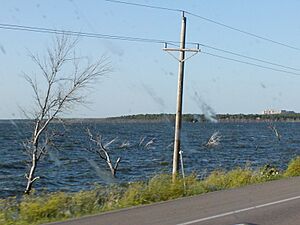
Between 1993 and 1999, there was a lot of rain. The lake doubled in size. More than 300 homes were flooded, and 70,000 acres (28,000 ha) of farmland was covered by water. The Spirit Lake Tribe's land was also badly damaged.
To help with the flooding, North Dakota and the U.S. government have spent over $450 million. They have built dikes (walls to hold back water) and moved roads and power lines. They also built artificial outlets to let water out.
In 1997, the U.S. Congress asked the Army Corps of Engineers to design an outlet. This outlet would help control the lake's level. The Corps' plan included ways to clean and check the water.
North Dakota thought the Corps' plan was too expensive. So, in 2003, the state built its own outlet. This outlet sends water from Devils Lake into the Sheyenne River. It cost $28 million and was finished in 2005.
The outlet was not used in 2006 because of worries about water quality. But in July 2009, it was used at its full capacity for the first time. The National Weather Service keeps track of the lake's water levels.
Fun at Devils Lake
Devils Lake is a popular spot for fishing and other water sports. It is known as the "perch capital of the world." There are many boat ramps and places to enjoy the lake. Fishing and ice fishing bring in over $20 million each year.
White Horse Hill National Game Preserve is on the lake's southern shore. Grahams Island State Park is on an island in the lake. Other parks, like Black Tiger State Recreation Area, are also nearby. Shelvers Grove State Recreation Area is now closed due to the flooding.
The Problem with Carp
The rising water levels of Devils Lake could cause a problem. A type of "rough fish" called the common carp lives in the Red River Valley. There is a fear that these carp could get into Devils Lake.
Carp reproduce very quickly. There are no natural enemies for carp in Devils Lake. If they get in, their population could grow very fast. This would be bad for the game fish already in the lake, like walleye and northern pike. It could really hurt the sport fishing business.
To stop the carp, some ideas have been suggested. One idea is to use chemicals in creeks near the lake to kill fish. In 2005, tests showed no carp in Devils Lake. But some were found within two miles of the lake. It seems that thick cattail plants have stopped the carp from moving further.
Railroad Challenges
The rising water levels also caused problems for the BNSF Railway. Between 2009 and 2013, freight trains could not use a 19-mile section of track near the lake. However, Amtrak's Empire Builder passenger train continued to use the line.
In 2010, experts thought Amtrak might have to rebuild the bridge over the lake. Or, they might have to change the train's route.
On June 15, 2011, BNSF and Amtrak agreed to rebuild the railway line. Each company would pay one-third of the cost. The state of North Dakota got a special grant to pay for the last third. The track was rebuilt and raised higher. Now, trains can use the line through Devils Lake again.
 | James Van Der Zee |
 | Alma Thomas |
 | Ellis Wilson |
 | Margaret Taylor-Burroughs |


