Churchs Ferry, North Dakota facts for kids
Quick facts for kids
Churchs Ferry, North Dakota
|
|
|---|---|

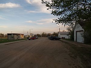
Street in Churchs Ferry
|
|

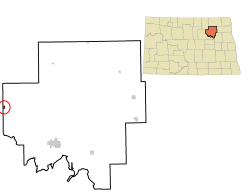
Location of Churchs Ferry, North Dakota
|
|
| Country | United States |
| State | North Dakota |
| County | Ramsey |
| Founded | 1883 |
| Unincorporated (dissolved) | September 30, 2022 |
| Area | |
| • Total | 0.43 sq mi (1.12 km2) |
| • Land | 0.43 sq mi (1.12 km2) |
| • Water | 0.00 sq mi (0.00 km2) |
| Elevation | 1,450 ft (442 m) |
| Population
(2020)
|
|
| • Total | 9 |
| • Estimate
(2022)
|
11 |
| • Density | 20.83/sq mi (8.04/km2) |
| Time zone | UTC-6 (CST) |
| • Summer (DST) | UTC-5 (CDT) |
| ZIP code |
58325
|
| Area code(s) | 701 |
| FIPS code | 38-14140 |
| GNIS feature ID | 2831213 |
Churchs Ferry is a small place in Ramsey County, North Dakota, United States. It is called an unincorporated community, which means it doesn't have its own city government anymore. This community has been greatly affected by the growing Devils Lake nearby. In 2020, only 9 people lived there.
Churchs Ferry started as a city in 1883. But in September 2022, the people living there decided to stop being a city. It then became part of Ramsey County.
Contents
History of Churchs Ferry
The Rising Devils Lake
The water level of Devils Lake started to rise a lot in the early 1990s. This caused big problems for the towns around it. More than 400 homes near the lake had to be moved or were destroyed. Churchs Ferry was one of the communities that was bought out by the government because of the rising water. Another town, Penn, was also affected. Even though many people left, a few still live in both areas.
Devils Lake keeps getting bigger because its natural overflow point, called Tolna Coulee, is much higher than the lake itself. This means water can't easily flow out. In the 1880s, the lake was so large that a man named Irvine Church ran a ferry service in the area. This is how the town got its name! However, by 1940, the lake had almost completely dried up. Now, the lake is growing back to its larger size again.
Becoming an Unincorporated Community
On January 10, 2012, the people of Churchs Ferry voted on whether to stay an official town. The vote was 5 to 2 to remain a town.
However, on June 14, 2022, the six remaining residents voted again. This time, they decided to dissolve the city, with a vote of 5 to 1. The city officially stopped existing on September 1, 2022. Paul Christenson was the last mayor of Churchs Ferry.
Geography of Churchs Ferry
Churchs Ferry is a small area of land. According to the United States Census Bureau, the community covers about 0.43 square miles (1.12 square kilometers). All of this area is land, with no water.
People of Churchs Ferry (Demographics)
Demographics is a way of looking at information about the people who live in a place. This includes how many people there are and what they are like.
| Historical population | |||
|---|---|---|---|
| Census | Pop. | %± | |
| 1900 | 264 | — | |
| 1910 | 457 | 73.1% | |
| 1920 | 353 | −22.8% | |
| 1930 | 295 | −16.4% | |
| 1940 | 244 | −17.3% | |
| 1950 | 223 | −8.6% | |
| 1960 | 161 | −27.8% | |
| 1970 | 139 | −13.7% | |
| 1980 | 139 | 0.0% | |
| 1990 | 118 | −15.1% | |
| 2000 | 77 | −34.7% | |
| 2010 | 12 | −84.4% | |
| 2020 | 9 | −25.0% | |
| 2022 (est.) | 11 | −8.3% | |
| U.S. Decennial Census 2020 Census |
|||
2010 Census Information
In 2010, there were 12 people living in Churchs Ferry. These people lived in 5 different homes, and all 5 were families. The population density was about 27.9 people per square mile (10.8 people per square kilometer). There were also 5 housing units, which are places where people can live.
Everyone living in Churchs Ferry in 2010 was White.
Out of the 5 homes, one had children under 18 living there. All the homes were made up of married couples living together. The average number of people in each home was 2.40, and the average family size was also 2.40.
The average age of people in Churchs Ferry in 2010 was 48.5 years old. About 8.3% of the residents were under 18. Another 8.3% were between 18 and 24. A quarter (25%) were between 25 and 44. Most people (58.4%) were between 45 and 64 years old. There were no residents aged 65 or older. The number of males and females was equal, with 50% male and 50% female.
Transportation in Churchs Ferry
The Amtrak train called the Empire Builder goes through Churchs Ferry. This train travels between Seattle/Portland and Chicago. It uses the BNSF train tracks. However, the train does not stop in Churchs Ferry. The closest train station is in Devils Lake, which is about 20 miles (32 km) to the southeast.
Education in Churchs Ferry
Children living in Churchs Ferry attend schools in the Leeds School District.
See also
 In Spanish: Churchs Ferry para niños
 | May Edward Chinn |
 | Rebecca Cole |
 | Alexa Canady |
 | Dorothy Lavinia Brown |

