
Towner County, North Dakota facts for kids
Quick facts for kids
Towner County
|
|
|---|---|

Postcard. Towner County Courthouse in Cando, North Dakota, a historic Queen Anne-style building.
|
|

Location within the U.S. state of North Dakota
|
|
 North Dakota's location within the U.S. |
|
| Country | |
| State | |
| Founded | March 8, 1883 (created) January 24, 1884 (organized) |
| Named for | Oscar M. Towner |
| Seat | Cando |
| Largest city | Cando |
| Area | |
| • Total | 1,041 sq mi (2,700 km2) |
| • Land | 1,025 sq mi (2,650 km2) |
| • Water | 17 sq mi (40 km2) 1.6% |
| Population
(2020)
|
|
| • Total | 2,162 |
| • Estimate
(2022)
|
2,064 |
| • Density | 2.0768/sq mi (0.8019/km2) |
| Time zone | UTC−6 (Central) |
| • Summer (DST) | UTC−5 (CDT) |
| Congressional district | At-large |
Towner County is a place in North Dakota, a state in the United States. In 2020, about 2,162 people lived there. The main town, or county seat, is Cando. It's located just south of the border with Manitoba, Canada.
Contents
History of Towner County
The Dakota Territory government officially created Towner County on March 8, 1883. It was formed from parts of Cavalier and Rolette counties. The county was named after Oscar M. Towner, who was a local businessman.
At first, Towner County was connected to Pembina County for legal and administrative tasks. This changed on January 24, 1884, when Towner County became fully organized on its own. The borders of Towner County have stayed the same since it was first created.
It's important to know that the city of Towner, North Dakota is in a different county, McHenry County.
Geography and Landscape
Towner County is located in the northern part of North Dakota. This means its northern border is also the border between the United States and Canada. The land here has rolling hills, and you'll find many lakes and ponds. Most of the land in the county is used for farming.
A special feature called the Laurentian Divide runs through Towner County. This divide means that water on the north side flows north, and water on the south side flows south. The county also slopes slightly towards the east.
The total area of Towner County is about 1,041 square miles (2,696 square kilometers). Most of this is land (1,025 square miles), and a smaller part is water (17 square miles).

Major Roads in Towner County
 U.S. Route 281
 North Dakota Highway 4
 North Dakota Highway 5
 North Dakota Highway 17
 North Dakota Highway 66
Neighboring Areas
Towner County shares its borders with several other counties and areas:
- Municipality of Killarney-Turtle Mountain, Manitoba - to the northwest
- Cartwright-Roblin Municipality, Manitoba - to the north
- Municipality of Louise, Manitoba - to the northeast
- Cavalier County - to the east
- Ramsey County - to the southeast
- Benson County - to the south
- Pierce County - to the southwest
- Rolette County - to the west
Protected Natural Areas
Towner County is home to several national wildlife refuges, which are special places set aside to protect animals and their habitats:
- Brumba National Wildlife Refuge
- Lake Alice National Wildlife Refuge (part of it)
- Rock Lake National Wildlife Refuge
- Snyder Lake National Wildlife Refuge
Lakes in the County
Here are some of the lakes you can find in Towner County:
- Armourdale Lake
- Brumba Pool
- Lake Alice (part of it)
- McLaughlin Lake
- Moore Lake
- Pound Lake
- Rock Lake
- Snyder Lake
People and Population
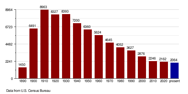
| Historical population | |||
|---|---|---|---|
| Census | Pop. | %± | |
| 1890 | 1,450 | — | |
| 1900 | 6,491 | 347.7% | |
| 1910 | 8,963 | 38.1% | |
| 1920 | 8,327 | −7.1% | |
| 1930 | 8,393 | 0.8% | |
| 1940 | 7,200 | −14.2% | |
| 1950 | 6,360 | −11.7% | |
| 1960 | 5,624 | −11.6% | |
| 1970 | 4,645 | −17.4% | |
| 1980 | 4,052 | −12.8% | |
| 1990 | 3,627 | −10.5% | |
| 2000 | 2,876 | −20.7% | |
| 2010 | 2,246 | −21.9% | |
| 2020 | 2,162 | −3.7% | |
| 2022 (est.) | 2,064 | −8.1% | |
| U.S. Decennial Census 1790-1960 1900-1990 1990-2000 2010-2020 |
|||
Population Changes Over Time
The population of Towner County has changed quite a bit over the years. In 1910, it reached its highest number with 8,963 people. Since then, the population has slowly decreased. In 2020, the census counted 2,162 people living in the county.
People and Households (2010 Census)
In 2010, there were 2,246 people living in Towner County. There were 1,048 households, which are groups of people living together. About 639 of these were families.
Most people in the county were white (96.7%). About 2.2% were American Indian. A small number of people were from other racial backgrounds.
Many people in Towner County have German (46.5%) or Norwegian (41.5%) family backgrounds. Other common ancestries include Irish, English, and Swedish.
The average age of people in Towner County was about 50.3 years old.
Towns and Communities
Cities in Towner County
Small Unincorporated Communities
These are smaller places that don't have their own city government:
Townships
Townships are smaller local areas within the county. Here are the townships in Towner County:
- Armourdale
- Atkins
- Bethel
- Cando
- Coolin
- Crocus
- Dash
- Gerrard
- Grainfield
- Howell
- Lansing
- Maza
- Monroe
- Mount View
- New City
- Olson
- Paulson
- Picton
- Rock Lake
- Sidney
- Smith
- Sorenson
- Springfield
- Teddy
- Twin Hill
- Victor
- Virginia
- Zion
Education in Towner County
Children in Towner County attend schools in several different school districts:
- Leeds Public School District 6
- Mount Pleasant Public School District 4
- Munich Public School District 19
- North Star School District
- Starkweather Public School District 44
Some school districts that used to exist in the county have since merged with others. For example, the Bisbee-Egeland School District and the Cando School District both merged into the North Star Schools in 2008.
See also
 In Spanish: Condado de Towner para niños
