Agate, North Dakota facts for kids
Quick facts for kids
Agate, North Dakota
|
|
|---|---|
| Country | United States |
| State | North Dakota |
| County | Rolette, Towner |
| Elevation | 1,657 ft (505 m) |
| Time zone | UTC-6 (Eastern (CST)) |
| • Summer (DST) | UTC-5 (EDT) |
| ZIP codes |
58310
|
| Area code(s) | 701 |
| GNIS feature ID | 1033828 |
Agate is a small, unincorporated community in North Dakota, USA. This means it's a group of homes and buildings that isn't officially a town or city with its own local government.
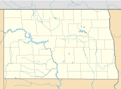
Agate is located in the southeastern part of Rolette County and the western part of Towner County. It sits along North Dakota Highway 66. You can find it south of Rolla and northwest of Cando. Rolla and Cando are the main towns, called county seats, for Rolette and Towner Counties.
The land in Agate is about 1,657 feet (505 meters) above sea level. If you wanted to send mail there, the ZIP code for Agate is 58310.
History of Agate
The community of Agate first started to be planned out in 1906. Just one year later, in 1907, a post office was opened in Agate. This post office helped people send and receive mail for many years. However, it eventually closed down in 1964.
Agate got its name from something special found in the area. The community was named after the beautiful agate stones that are naturally found in the local ground.
 | Aaron Henry |
 | T. R. M. Howard |
 | Jesse Jackson |


