
Rolette County, North Dakota facts for kids
Quick facts for kids
Rolette County
|
|
|---|---|

|
|

Location within the U.S. state of North Dakota
|
|
 North Dakota's location within the U.S. |
|
| Country | |
| State | |
| Founded | January 4, 1873 (created) October 14, 1884 (organized) |
| Named for | Joseph Rolette |
| Seat | Rolla |
| Largest community | Belcourt |
| Area | |
| • Total | 939.499 sq mi (2,433.29 km2) |
| • Land | 903.042 sq mi (2,338.87 km2) |
| • Water | 36.457 sq mi (94.42 km2) 3.9% |
| Population
(2020)
|
|
| • Total | 12,187 |
| • Estimate
(2023)
|
11,728 |
| • Density | 12.97/sq mi (5.01/km2) |
| Time zone | UTC−6 (Central) |
| • Summer (DST) | UTC−5 (CDT) |
| Congressional district | At-large |
Rolette County is a county in North Dakota, a state in the United States. In 2020, about 12,187 people lived here. The main town, or county seat, is Rolla.
Contents
History of Rolette County
The Dakota Territory government officially created Rolette County on January 4, 1873. It was formed from a part of Buffalo County. The county was named after Joseph Rolette Jr.. He was a fur trader and an important political leader from Pembina.
The county government officially started on October 14, 1884. At first, Dunseith was chosen as the county seat. This is the main town where the county government operates. Later, in 1885, the county seat moved to Saint John. Finally, in 1889, it was moved to Rolla, where it remains today.
The county's borders were changed a couple of times, in 1883 and 1887. Since 1887, the county has kept its current shape and size.
A special place called the International Peace Garden is located in the northwest part of the county. It sits right on the border between the United States and Manitoba, Canada.
Geography of Rolette County
Rolette County is located on the northern border of North Dakota, right next to Canada. Some creeks, like Gimby Creek and Wakopa Creek, flow into the county from Canada. The land in the southern part of the county has dry, rolling hills. In the north and northwest, you'll find greener, low hills with many lakes and ponds.
A part of the Turtle Mountain plateau is in the northwestern area of the county. The land generally slopes down towards the south and east. The highest point in the county is its northwest corner, which is about 2,195 feet (669 meters) above sea level.
The Turtle Mountain Indian Reservation is located in the northeast part of Rolette County.
According to the United States Census Bureau, the county covers a total area of about 939.5 square miles (2,433.3 square kilometers). Out of this, 903.0 square miles (2,338.8 square kilometers) is land, and 36.5 square miles (94.5 square kilometers) is water. This means about 3.9% of the county's area is water.
Main Roads in Rolette County
 U.S. Highway 281
 North Dakota Highway 3
 North Dakota Highway 5
 North Dakota Highway 30
 North Dakota Highway 43
 North Dakota Highway 66
Neighboring Areas
Rolette County shares borders with other counties and municipalities:
- Municipality of Boissevain-Morton, Manitoba - to the northwest
- Municipality of Killarney-Turtle Mountain, Manitoba - to the northeast
- Towner County - to the east
- Pierce County - to the south
- Bottineau County - to the west
Protected Natural Areas
These areas help protect wildlife and nature in the county:
- Lords Lake National Wildlife Refuge (part of it)
- Rabb Lake National Wildlife Refuge
- School Section Lake National Wildlife Refuge
- Willow Lake National Wildlife Refuge
Lakes in Rolette County
Rolette County has many lakes and ponds. Here are some of them:
- Belcourt Lake
- Bigham Lake
- Bymes Lake
- Carpenters Lake
- Coon Lake
- Ducker Lake
- Gatten Lake
- Girl Lake
- Gordon Lake
- Hartley Lake (part)
- Horseshoe Lake
- Island Lake
- Lagerquist Lake
- Lake Upsilon
- Little Gurr Lake
- Long Lake
- Lords Lake (part)
- Mill Lake
- Rabb Lake
- School Section Lake
- Schutte Lake
- South Messier Lake (part)
- Twin Lake
- Twin Lakes (part)
- Willow Lake
Population and People
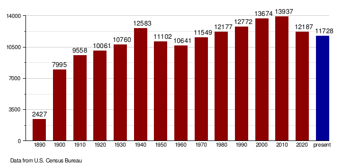
| Historical population | |||
|---|---|---|---|
| Census | Pop. | %± | |
| 1890 | 2,427 | — | |
| 1900 | 7,995 | 229.4% | |
| 1910 | 9,558 | 19.5% | |
| 1920 | 10,061 | 5.3% | |
| 1930 | 10,760 | 6.9% | |
| 1940 | 12,583 | 16.9% | |
| 1950 | 11,102 | −11.8% | |
| 1960 | 10,641 | −4.2% | |
| 1970 | 11,549 | 8.5% | |
| 1980 | 12,177 | 5.4% | |
| 1990 | 12,772 | 4.9% | |
| 2000 | 13,674 | 7.1% | |
| 2010 | 13,937 | 1.9% | |
| 2020 | 12,187 | −12.6% | |
| 2023 (est.) | 11,728 | −15.8% | |
| U.S. Decennial Census 1790–1960 1900–1990 1990–2000 2010–2020 |
|||
What the 2020 Census Shows
The 2020 census counted 12,187 people living in Rolette County. There were 4,114 households and 2,857 families. The population density was about 13.5 people per square mile (5.2 people per square kilometer).
The people living in the county are from different backgrounds:
- About 19.0% were White.
- About 0.1% were African American.
- About 76.1% were Native American. This is the largest group.
- About 0.2% were Asian.
- About 0.1% were Pacific Islander.
- About 0.1% were from other races.
- About 4.3% were from two or more races.
- Hispanic or Latino people made up about 1.1% of the population.
Life in Rolette County (2022)
In 2022, there were about 3,668 households in the county. On average, each household had about 3.31 people. The average rent for a home was about $482 per month.
The average income for a household in 2022 was $53,806. About 66.1% of households owned their homes. About 25.7% of the people in the county lived at or below the poverty line. This means they had very low incomes.
About 54.9% of the people in the county had jobs. When it comes to education, 85.4% of the population had a high school diploma. Also, 16.2% had a bachelor's degree or higher.
The most common backgrounds reported by people were German (7.0%), Norwegian (6.2%), and French (2.3%). The average age in the county was 31.1 years old.
Population Changes Over Time
This chart shows how the population of Rolette County has changed over many years:
Towns and Communities
Rolette County has several towns and smaller communities where people live.
Cities in Rolette County
Census-Designated Places
These are areas that are like towns but are not officially incorporated as cities.
Unincorporated Communities
These are smaller communities that don't have their own local government.
Townships
Townships are smaller local government areas within the county.
- Kohlmeier
- Maryville
- Shell Valley
- South Valley
- Holmes
Education in Rolette County
Several school districts serve the students in Rolette County.
- Belcourt Public School District 7 (also known as Turtle Mountain Community School, working with the Bureau of Indian Education (BIE))
- Bottineau Public School District 1
- Dunseith Public School District 1
- Mount Pleasant Public School District 4
- North Star School District
- Rolette Public School District 29
- Rugby Public School District 5
- St. John Public School District 3
One former school district was Wolford Public School District 1, which closed in 2019.
Images for kids
See also
 In Spanish: Condado de Rolette para niños
