Buffalo County, South Dakota facts for kids
Quick facts for kids
Buffalo County
|
|
|---|---|

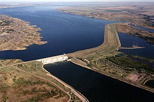
Fort Thompson Big Bend Dam.
|
|

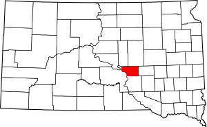
Location within the U.S. state of South Dakota
|
|
 South Dakota's location within the U.S. |
|
| Country | |
| State | |
| Founded | 1864 (created) 1871 (organized) |
| Named for | American buffalo |
| Seat | Gann Valley |
| Largest community | Fort Thompson |
| Area | |
| • Total | 488 sq mi (1,260 km2) |
| • Land | 471 sq mi (1,220 km2) |
| • Water | 16 sq mi (40 km2) 3.4% |
| Population
(2020)
|
|
| • Total | 1,948 |
| • Estimate
(2023)
|
1,884 |
| • Density | 3.992/sq mi (1.5412/km2) |
| Time zone | UTC−6 (Central) |
| • Summer (DST) | UTC−5 (CDT) |
| Congressional district | At-large |
Buffalo County is a special area in the state of South Dakota, United States. It's like a smaller region within the state. In 2020, about 1,948 people lived there. The main town, or county seat, is Gann Valley. It's a very small place, with only 10 people, making it the least populated county seat in the whole United States!
Buffalo County was first set up in 1864. It officially became organized in 1871, when it was part of the Dakota Territory. Most of Buffalo County is home to the Crow Creek Indian Reservation. This reservation is where the Crow Creek Sioux Tribe lives.
In 2013, studies showed that about 41% of the people in Buffalo County lived in poverty. This means they had a very low income. The average household income in 2013 was $21,572. This was the lowest income for any county in South Dakota and the entire United States at that time.
Contents
Geography of Buffalo County
Buffalo County is located in the middle of South Dakota. The big Missouri River flows along its western side. The land here has rolling hills and is quite dry. Some parts of the county are used for farming. Crow Creek flows through the southern and western parts of the county. It eventually joins the Missouri River.
The county covers a total area of about 488 square miles (1,264 square kilometers). Most of this area, about 471 square miles (1,220 square kilometers), is land. The rest, about 16 square miles (41 square kilometers), is water.
Main Roads in Buffalo County
These are the important roads that help people travel through Buffalo County:
Neighboring Counties
Buffalo County shares its borders with several other counties:
- Hand County to the northeast
- Jerauld County to the east
- Brule County to the south
- Lyman County to the west
- Hyde County to the northwest
Special Natural Areas
One important protected area in Buffalo County is:
- Pease State Game Production Area
Lakes in the County
Buffalo County also has some lakes, including parts of larger ones:
- Bedashosha Lake
- Lake Francis Case (part of it is in Buffalo County)
- Lake Sharpe (part of it is in Buffalo County)
History of Buffalo County
When Buffalo County was first created, it was much larger than it is today. It stretched all the way north to Canada! It also included parts of what is now North Dakota. Over time, its size changed as new states and territories were formed. In 1889, the Dakota Territory was split into two separate states, North Dakota and South Dakota. This change made Buffalo County's borders what they are now.
People of Buffalo County
The number of people living in Buffalo County has changed over the years. In 1870, there were only 246 people. The population grew to 1,790 by 1900. It has stayed around 1,500 to 2,000 people for many decades. In 2020, the population was 1,948.
Population in 2020
According to the 2020 census, there were 1,948 people living in Buffalo County. There were 497 households, which means 497 groups of people living together. The county had 570 housing units in total.
Population in 2010
In the 2010 census, there were 1,912 people in Buffalo County. Most of the people living there, about 84%, were Native American. About 14.8% were white. The average age of people in the county was 25 years old. This means it's a fairly young population.
The average income for a household in 2010 was $27,926. About 49.3% of all people in the county were living below the poverty line. This included more than half of the children under 18.
Communities in Buffalo County
Buffalo County has a few towns and smaller communities.
Main Towns (Census-designated places)
- Gann Valley (This is the county seat, where the main government offices are)
- Fort Thompson
Smaller Communities (Unincorporated)
These are places that don't have their own local government:
- Crow Creek
- North Buffalo
- Shelby
- Southeast Buffalo
Township
- Elvira
Images for kids
-
Fort Thompson Big Bend Dam.
See also
 In Spanish: Condado de Buffalo (Dakota del Sur) para niños
 | Bayard Rustin |
 | Jeannette Carter |
 | Jeremiah A. Brown |


