Jerauld County, South Dakota facts for kids
Quick facts for kids
Jerauld County
|
|
|---|---|

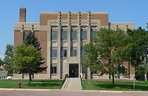
Jerauld County Courthouse in Wessington Springs
|
|

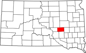
Location within the U.S. state of South Dakota
|
|
 South Dakota's location within the U.S. |
|
| Country | |
| State | |
| Founded | 1883 |
| Named for | H. J. Jerauld |
| Seat | Wessington Springs |
| Largest city | Wessington Springs |
| Area | |
| • Total | 533 sq mi (1,380 km2) |
| • Land | 526 sq mi (1,360 km2) |
| • Water | 6.4 sq mi (17 km2) 1.2% |
| Population
(2020)
|
|
| • Total | 1,663 |
| • Estimate
(2023)
|
1,660 |
| • Density | 3.120/sq mi (1.2047/km2) |
| Time zone | UTC−6 (Central) |
| • Summer (DST) | UTC−5 (CDT) |
| Congressional district | At-large |
Jerauld County is a county located in the state of South Dakota in the United States. A county is like a smaller area within a state, often with its own local government. In 2020, about 1,663 people lived here. The main town and county seat (where the county government is) is Wessington Springs.
Contents
History of Jerauld County
The area that is now Jerauld County has an interesting past. In 1873, it was first set up as a county called Wetmore County.
A few years later, in 1881, Wetmore County was combined with a county to its south, Cragin County. Together, they formed a larger Aurora County.
But this change didn't last long! In 1883, the area that used to be Wetmore County was made into its own county again. This time, it was named Jerauld County, which is what it's still called today. The county was named after H. J. Jerauld, who was a lawmaker at the time.
Geography of Jerauld County
Jerauld County's land is mostly made up of gentle, rolling hills. Most of this land is used for farming. The county's land slopes down towards the south and east. The highest point in the county is on its western border, close to the northwest corner. This spot is about 1,932 feet (589 meters) above sea level.
The county covers a total area of about 533 square miles (1,380 square kilometers). Most of this is land (526 square miles or 1,362 square kilometers), and a small part, about 6.4 square miles (17 square kilometers), is water.
Main Roads in Jerauld County
These are the most important roads that go through Jerauld County:
Neighboring Counties
Jerauld County shares its borders with these other counties:
- Beadle County - to the northeast
- Sanborn County - to the east
- Aurora County - to the south
- Brule County - to the southwest
- Buffalo County - to the west
- Hand County - to the northwest
Special Natural Areas
Jerauld County has some special areas set aside for nature and wildlife:
- Crow Lake State Game Production Area
- Horseshoe Lake State Game Production Area
Lakes in Jerauld County
You can find these lakes in Jerauld County:
- Bakers Lake
- Cottonwood Lake
- Horseshoe Lake
- Long Lake
- Rempter Lake
- Twin Lakes (part of it)
Who Lives in Jerauld County?
| Historical population | |||
|---|---|---|---|
| Census | Pop. | %± | |
| 1890 | 3,605 | — | |
| 1900 | 2,798 | −22.4% | |
| 1910 | 5,120 | 83.0% | |
| 1920 | 6,338 | 23.8% | |
| 1930 | 5,816 | −8.2% | |
| 1940 | 4,752 | −18.3% | |
| 1950 | 4,476 | −5.8% | |
| 1960 | 4,048 | −9.6% | |
| 1970 | 3,310 | −18.2% | |
| 1980 | 2,929 | −11.5% | |
| 1990 | 2,425 | −17.2% | |
| 2000 | 2,295 | −5.4% | |
| 2010 | 2,071 | −9.8% | |
| 2020 | 1,663 | −19.7% | |
| 2023 (est.) | 1,660 | −19.8% | |
| U.S. Decennial Census 1790-1960 1900-1990 1990-2000 2010-2020 |
|||
The number of people living in Jerauld County changes over time. In 2020, the census counted 1,663 people living there. This means there were about 3.2 people per square mile. There were also 952 homes in the county.
Back in 2010, there were 2,071 people. Most people in the county were white (97.0%). A small number of people were from other racial backgrounds. About 4.1% of the people said they were of Hispanic or Latino origin.
The average age of people in Jerauld County in 2010 was about 48.6 years old.
Local News
The county has its own weekly newspaper called the True Dakotan. It helps keep everyone in the community updated on local news and events.
Communities in Jerauld County
Jerauld County has several towns and communities where people live and work.
City
- Wessington Springs (This is the main city and the county seat.)
Towns
Special Places (Census-designated place)
- Spring Valley Colony
Smaller Communities (Unincorporated)
These are small places that are not officially organized as cities or towns:
- Crow Lake
- Dale
Townships
Townships are smaller areas within a county, often used for local government or land division. Jerauld County has these townships:
- Alpena
- Anina
- Blaine
- Chery
- Crow
- Crow Lake
- Franklin
- Harmony
- Logan
- Marlar
- Media
- Pleasant
- Viola
- Wessington Springs
Unorganized Territory
- Dale (This is an area that doesn't have its own local township government.)
See also
 In Spanish: Condado de Jerauld para niños
 | Delilah Pierce |
 | Gordon Parks |
 | Augusta Savage |
 | Charles Ethan Porter |

