Lyman County, South Dakota facts for kids
Quick facts for kids
Lyman County
|
|
|---|---|

|
|

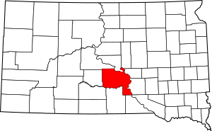
Location within the U.S. state of South Dakota
|
|
 South Dakota's location within the U.S. |
|
| Country | |
| State | |
| Founded | 1893 |
| Named for | W. P. Lyman |
| Seat | Kennebec |
| Largest community | Lower Brule |
| Area | |
| • Total | 1,707 sq mi (4,420 km2) |
| • Land | 1,642 sq mi (4,250 km2) |
| • Water | 65 sq mi (170 km2) 3.8% |
| Population
(2020)
|
|
| • Total | 3,718 |
| • Estimate
(2023)
|
3,705 |
| • Density | 2.1781/sq mi (0.8410/km2) |
| Time zone | UTC−6 (Central) |
| • Summer (DST) | UTC−5 (CDT) |
| Congressional district | At-large |
Lyman County is a county located in the state of South Dakota in the United States. In 2020, about 3,718 people lived there. The main town, or county seat, is Kennebec.
Lyman County was officially created on January 8, 1873. However, it wasn't fully set up until May 21, 1893. Its borders changed a few times over the years. The county is named after W. P. Lyman, who was a politician.
Contents
History of Lyman County
Lyman County was first created in 1873 and then fully organized in 1893. The town of Oacoma was the first county seat in 1891. Later, in 1922, the county seat was moved to Kennebec, where it is today.
Geography of Lyman County
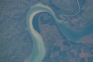
Lyman County is surrounded by important rivers. The Missouri River forms its northern and eastern borders. The White River flows along the western part of its southern border. It then continues east through the county before joining the Missouri River. Bad Horse Creek also flows through the county and into the Missouri River.
The land in Lyman County has rolling hills. It slopes down towards the rivers. Most of the land is used for farming. The county covers a total area of about 1,707 square miles. Out of this, 1,642 square miles is land, and 65 square miles is water.
Main Roads in Lyman County
Public Transportation
- Jefferson Lines
Neighboring Counties
- Hughes County - north
- Hyde County - northeast
- Buffalo County - northeast
- Brule County - east
- Charles Mix County - southeast
- Gregory County - south
- Tripp County - south
- Mellette County - southwest
- Jones County - west
- Stanley County - northwest
Protected Natural Areas
Lyman County has several protected areas where nature is preserved. These include:
- Brakke State Game Production Area
- Brye Bottom State Game Production Area
- Bull Creek State Game Production Area
- Carpenter State Game Production Area
- Cedar Creek Recreation Area
- Counselor Creek Recreation Area
- Dude Ranch State Lakeside Use Area
- Fate Dam State Game Production Aea
- Fort Pierre National Grassland (part)
- Good Soldier Creek Recreation Area
- Iona State Game Production Area
- Iron Nation Recreation Area
- Lindely State Game Production Area
- Lower Brule Recreation Area
- Narrows Recreation Area
- Neugebauer State Game Production Area
- Reis Bottom State Game Production Area
- Salzmann State Game Production Area
Lakes in Lyman County
- Lake Francis Case (part)
- Lake Sharpe (part)
Population of Lyman County
| Historical population | |||
|---|---|---|---|
| Census | Pop. | %± | |
| 1880 | 124 | — | |
| 1890 | 233 | 87.9% | |
| 1900 | 2,632 | 1,029.6% | |
| 1910 | 10,848 | 312.2% | |
| 1920 | 6,591 | −39.2% | |
| 1930 | 6,335 | −3.9% | |
| 1940 | 5,045 | −20.4% | |
| 1950 | 4,572 | −9.4% | |
| 1960 | 4,428 | −3.1% | |
| 1970 | 4,060 | −8.3% | |
| 1980 | 3,864 | −4.8% | |
| 1990 | 3,638 | −5.8% | |
| 2000 | 3,895 | 7.1% | |
| 2010 | 3,755 | −3.6% | |
| 2020 | 3,718 | −1.0% | |
| 2023 (est.) | 3,705 | −1.3% | |
| U.S. Decennial Census 1790-1960 1900-1990 1990-2000 2010-2020 |
|||
2020 Census Information
According to the 2020 census, 3,718 people lived in Lyman County. There were 1,303 households and 892 families. This means there were about 2.3 people per square mile. There were also 1,546 housing units available.
2010 Census Information
In 2010, there were 3,755 people living in the county. There were 1,392 households and 967 families. About 58.3% of the people were white, and 38.2% were Native American. A small number of people were Asian, Black, or from other backgrounds. About 1.1% of the population was of Hispanic or Latino origin.
The average household had about 2.67 people, and the average family had about 3.19 people. The median age in the county was 36.1 years old. The median income for a household was $36,323. About 18.8% of the population lived below the poverty line.
Communities in Lyman County
City
Towns
Census-Designated Places
These are areas that are like towns but are not officially incorporated as cities or towns.
- Lower Brule
- Vivian
- West Brule
Other Unincorporated Communities
These are small communities that are not part of any city or town.
Townships
Townships are smaller local government areas within the county.
- Bailey
- Butte
- Dorman
- Fairland
- Iona
- Morningside
- Oacoma
- Pleasant
- Pratt
- Reliance
- Rex
- Rose
- Rowe
- Sioux
- Stony Butte
Unorganized Territories
These are parts of the county that do not belong to any township or city.
- Black Dog
- Lafayette
- Lower Brule
- McClure
- Northwest Lyman
- South Lyman
See also
 In Spanish: Condado de Lyman para niños
 | Ernest Everett Just |
 | Mary Jackson |
 | Emmett Chappelle |
 | Marie Maynard Daly |


