
Gregory County, South Dakota facts for kids
Quick facts for kids
Gregory County
|
|
|---|---|

|
|

Location within the U.S. state of South Dakota
|
|
 South Dakota's location within the U.S. |
|
| Country | |
| State | |
| Founded | 1862 (created) 1898 (organized) |
| Named for | J. Shaw Gregory |
| Seat | Burke |
| Largest city | Gregory |
| Area | |
| • Total | 1,054 sq mi (2,730 km2) |
| • Land | 1,015 sq mi (2,630 km2) |
| • Water | 39 sq mi (100 km2) 3.7% |
| Population
(2020)
|
|
| • Total | 3,994 |
| • Estimate
(2023)
|
4,018 |
| • Density | 3.7894/sq mi (1.4631/km2) |
| Time zone | UTC−6 (Central) |
| • Summer (DST) | UTC−5 (CDT) |
| Congressional district | At-large |
Gregory County is a cool place in South Dakota, a state in the United States. It's like a big neighborhood with its own government. In 2020, about 3,994 people lived here. The main town, where the county government is, is called Burke. Gregory County was started in 1862 and officially set up in 1898. It got its name from a politician named J. Shaw Gregory.
Contents
Geography of Gregory County
Gregory County covers a total area of about 1,054 square miles. Most of this area, around 1,015 square miles, is land. The rest, about 39 square miles, is water. That's about 3.7% of the county's total size!
Main Roads in Gregory County
These are the most important roads that help people travel around Gregory County:
 U.S. Highway 18
 U.S. Highway 281
 South Dakota Highway 43
 South Dakota Highway 44
 South Dakota Highway 47
 South Dakota Highway 251
 South Dakota Highway 1806
Neighboring Counties
Gregory County shares its borders with these other counties:
- Lyman County, South Dakota to the north
- Charles Mix County, South Dakota to the east
- Boyd County, Nebraska to the south
- Keya Paha County, Nebraska to the southwest
- Tripp County, South Dakota to the west
Special Protected Areas
Part of the Karl E. Mundt National Wildlife Refuge is located in Gregory County. This is a special place where wildlife is protected.
People of Gregory County
Here's how the population of Gregory County has changed over the years:
| Historical population | |||
|---|---|---|---|
| Census | Pop. | %± | |
| 1890 | 295 | — | |
| 1900 | 2,211 | 649.5% | |
| 1910 | 13,061 | 490.7% | |
| 1920 | 12,700 | −2.8% | |
| 1930 | 11,420 | −10.1% | |
| 1940 | 9,554 | −16.3% | |
| 1950 | 8,556 | −10.4% | |
| 1960 | 7,399 | −13.5% | |
| 1970 | 6,710 | −9.3% | |
| 1980 | 6,015 | −10.4% | |
| 1990 | 5,359 | −10.9% | |
| 2000 | 4,792 | −10.6% | |
| 2010 | 4,271 | −10.9% | |
| 2020 | 3,994 | −6.5% | |
| 2023 (est.) | 4,018 | −5.9% | |
| U.S. Decennial Census 1790-1960 1900-1990 1990-2000 2010-2020 |
|||
What the 2020 Census Showed
In 2020, there were 3,994 people living in Gregory County. These people lived in 1,721 households, and 1,070 of those were families. There were also 2,186 housing units, which are places where people can live.
What the 2010 Census Showed
Back in 2010, Gregory County had 4,271 people. Most people were white (89.6%), and about 7.5% were American Indian. People from other backgrounds also lived here. Many families had German roots (54.5%), and others had Irish, Czech, or Norwegian backgrounds.
The average age of people in the county was about 48 years old. The average income for a household was around $33,940 per year. About 16% of the people in the county were living below the poverty line.
Towns and Communities
Gregory County has several towns and communities where people live.
Cities in Gregory County
Smaller Towns in Gregory County
Special Places (CDPs)
- St. Charles is a "Census-designated place." This means it's an area identified for population counting, but it's not an officially incorporated town.
County Divisions (Townships)
The county is divided into thirteen smaller areas called townships:
- Burke
- Carlock
- Dickens
- Dixon
- Edens
- Ellston
- Fairfax
- Jones
- Landing Creek
- Pleasant Valley
- Star Valley
- Whetstone
Unorganized Areas
There are also four areas in the county that are not part of any township. They are:
- East Gregory
- North Gregory
- Southeast Gregory
- Spring Valley
Economy of Gregory County
The main ways people make a living in Gregory County are through farming and ranching. These activities are very important to the county's economy.
Historic Places
Gregory County has some interesting historic sites listed on the National Register of Historic Places. These include:
Images for kids
-
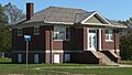
Carnegie Library in Dallas, South Dakota
See also
 In Spanish: Condado de Gregory para niños
