Keya Paha County, Nebraska facts for kids
Quick facts for kids
Keya Paha County
|
|
|---|---|

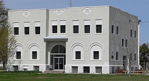
Keya Paha County Courthouse in Springview
|
|

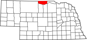
Location within the U.S. state of Nebraska
|
|
 Nebraska's location within the U.S. |
|
| Country | |
| State | |
| Founded | November 4, 1884 |
| Named for | Dakota for “Turtle Hill River” |
| Seat | Springview |
| Largest village | Springview |
| Area | |
| • Total | 774 sq mi (2,000 km2) |
| • Land | 773 sq mi (2,000 km2) |
| • Water | 0.8 sq mi (2 km2) 0.1%% |
| Population
(2020)
|
|
| • Total | 769 |
| • Density | 0.9935/sq mi (0.3836/km2) |
| Time zone | UTC−6 (Central) |
| • Summer (DST) | UTC−5 (CDT) |
| Congressional district | 3rd |
Keya Paha County is a county located in the state of Nebraska in the United States. As of the 2020 United States Census, about 769 people live there. The main town and county seat is Springview.
When Nebraska set up its license plate system in 1922, Keya Paha County was given the number 82. This was because it had the 82nd largest number of vehicles registered in the state at that time.
Contents
History of Keya Paha County
The name "Keya Paha" comes from the Dakota language. It means "turtle hill." This name was given to a group of small hills in the area. It also named the Keya Paha River, which flows through the county.
A small part of Keya Paha County and most of nearby Boyd County were not originally part of Nebraska. This land was part of the Dakota Territory. It was officially transferred to Nebraska in 1882.
Keya Paha County was officially formed in 1884. It was created from a part of Brown County.
Geography of Keya Paha County
Keya Paha County is located in northern Nebraska. It shares a border with the state of South Dakota. The land here has gentle, rolling hills. Flat areas are used for farming, sometimes with special center pivot irrigation systems.
The Keya Paha River flows through the northeastern part of the county. The Niobrara River flows along the southern border. The county covers about 774 square miles in total. Most of this is land, with a small amount of water. Keya Paha County is part of Nebraska's "Outback region."
Main Roads in Keya Paha County
Neighboring Counties
- Tripp County, South Dakota - north
- Gregory County, South Dakota - northeast
- Boyd County - east
- Holt County - southeast
- Rock County - south
- Brown County - south
- Cherry County - west
- Todd County, South Dakota - northwest
Protected Areas
- Part of the Niobrara National Scenic River is located here.
Population and People
| Historical population | |||
|---|---|---|---|
| Census | Pop. | %± | |
| 1890 | 3,920 | — | |
| 1900 | 3,076 | −21.5% | |
| 1910 | 3,452 | 12.2% | |
| 1920 | 3,594 | 4.1% | |
| 1930 | 3,203 | −10.9% | |
| 1940 | 3,235 | 1.0% | |
| 1950 | 2,160 | −33.2% | |
| 1960 | 1,672 | −22.6% | |
| 1970 | 1,340 | −19.9% | |
| 1980 | 1,301 | −2.9% | |
| 1990 | 1,029 | −20.9% | |
| 2000 | 983 | −4.5% | |
| 2010 | 824 | −16.2% | |
| 2020 | 769 | −6.7% | |
| 2022 (est.) | 787 | −4.5% | |
| US Decennial Census 1790-1960 1900-1990 1990-2000 2010 2020 2022 |
|||
In 2000, there were 983 people living in Keya Paha County. These people lived in 409 households, and 292 of these were families. Most of the people were White, with a small number of Native American people and people of mixed heritage. Some people also identified as Hispanic or Latino. Many residents had German, English, American, Irish, or Swedish family backgrounds.
About a quarter of the households had children under 18 living with them. Most households were married couples living together. Some people lived alone, especially those aged 65 or older. The average household had about 2.4 people.
The population included people of all ages. About 23.8% were under 18 years old. About 20.7% were 65 years or older. The average age in the county was 42 years old. For every 100 females, there were about 101 males.
Towns and Villages
Villages
- Burton
- Springview (This is the main town, also called the county seat)
Unincorporated Communities
These are smaller places that are not officially organized as towns or villages.
Former Communities
See also
 In Spanish: Condado de Keya Paha para niños
 | Toni Morrison |
 | Barack Obama |
 | Martin Luther King Jr. |
 | Ralph Bunche |

