Tripp County, South Dakota facts for kids
Quick facts for kids
Tripp County
|
|
|---|---|

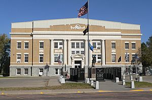
Tripp County courthouse in Winner
|
|

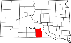
Location within the U.S. state of South Dakota
|
|
 South Dakota's location within the U.S. |
|
| Country | |
| State | |
| Founded | 1873 (created) 1909 (organized) |
| Named for | Bartlett Tripp |
| Seat | Winner |
| Largest city | Winner |
| Area | |
| • Total | 1,618 sq mi (4,190 km2) |
| • Land | 1,612 sq mi (4,180 km2) |
| • Water | 5.1 sq mi (13 km2) 0.3% |
| Population
(2020)
|
|
| • Total | 5,624 |
| • Estimate
(2023)
|
5,621 |
| • Density | 3.4759/sq mi (1.3421/km2) |
| Time zone | UTC−6 (Central) |
| • Summer (DST) | UTC−5 (CDT) |
| Congressional district | At-large |
Tripp County is a county located in the state of South Dakota in the United States. In 2020, about 5,624 people lived there. The main town and county seat is Winner.
Tripp County was first created in 1873. It officially became an organized county in 1909. The county is named after Bartlett Tripp. He was a famous lawyer, judge, and diplomat.
Exploring Tripp County's Geography
Tripp County is located in the southern part of South Dakota. Its southern border touches the state of Nebraska. To the north, you'll find the winding White River. The Keya Paha River also flows through the southern part of the county.
The land in Tripp County has rolling hills. These hills are shaped by many small valleys and streams. The land generally slopes down towards the south and east. The northern part of the county drops into the White River valley. The highest point in the county is about 2,552 feet (778 meters) above sea level.
The county covers a total area of 1,618 square miles (4,191 km²). Most of this area, 1,612 square miles (4,175 km²), is land. Only a small part, 5.1 square miles (13 km²), is water.
Main Roads and Highways
Several important roads help people travel through Tripp County. These highways connect the county to other places.
Neighboring Counties
Tripp County shares its borders with several other counties. Knowing these helps you understand its location.
- Lyman County - north
- Gregory County - east
- Keya Paha County, Nebraska - south
- Cherry County, Nebraska - southwest
- Todd County - west
- Mellette County - northwest
Special Protected Areas
Tripp County has several areas set aside to protect wildlife and nature. These are called State Game Production Areas. They are great places for animals to live.
- Beaulieu Lake State Game Production Area
- Brown State Game Production Area
- Covey Dam State Game Production Area
- Dog Ear Lake State Game Production Area
- George & Katherine Mann State Game Production Area
- Ideal Wetland State Game Production Area
- King Dam State Game Production Area
- Little Dog Ear Lake State Game Production Area
- McLaughlin State Game Production Area
- Rahm Lake State Game Production Area
- Roosevelt Lake State Game Production Area
- Snow Dam State Game Production Area
Lakes in the County
The county is home to Roosevelt Lake. It is a notable body of water in the area.
- Roosevelt Lake
People of Tripp County
The number of people living in Tripp County has changed over the years. Here's a look at the population counts from different times.
| Historical population | |||
|---|---|---|---|
| Census | Pop. | %± | |
| 1910 | 8,323 | — | |
| 1920 | 11,970 | 43.8% | |
| 1930 | 12,712 | 6.2% | |
| 1940 | 9,937 | −21.8% | |
| 1950 | 9,139 | −8.0% | |
| 1960 | 8,761 | −4.1% | |
| 1970 | 8,171 | −6.7% | |
| 1980 | 7,268 | −11.1% | |
| 1990 | 6,924 | −4.7% | |
| 2000 | 6,430 | −7.1% | |
| 2010 | 5,644 | −12.2% | |
| 2020 | 5,624 | −0.4% | |
| 2023 (est.) | 5,621 | −0.4% | |
| U.S. Decennial Census 1790-1960 1900-1990 1990-2000 2010-2020 |
|||
Population in 2020
In 2020, there were 5,624 people living in Tripp County. There were 2,233 households and 1,398 families. This means there were about 3.5 people per square mile. The county also had 2,762 housing units.
Population in 2010
Back in 2010, 5,644 people lived in the county. There were 2,419 households. About 1,509 of these were families. The population density was also about 3.5 people per square mile.
Most people in 2010 were white (83.1%). About 14.0% were American Indian. A small number were from other backgrounds. Many people had German (46.8%) or Irish (10.8%) family roots.
The average age of people in Tripp County in 2010 was 45.3 years old. About 26.9% of households had children under 18.
Towns and Communities
Tripp County has several towns and communities. These are places where people live and work.
Cities
Towns
- New Witten (The post office calls it "Witten.")
Special Census Places
These are areas that are like small towns but are counted separately for the census.
Small Unincorporated Communities
These are even smaller places that are not officially organized as towns.
Townships
Tripp County is divided into many smaller areas called townships. These help organize the county.
- Banner
- Beaver Creek
- Black
- Brunson
- Bull Creek
- Carter
- Colome
- Condon
- Curlew
- Dog Ear
- Elliston
- Greenwood
- Holsclaw
- Huggins
- Ideal
- Irwin
- Jordan
- Keyapaha
- King
- Lake
- Lamro
- Lincoln
- Lone Star
- Lone Tree
- McNeely
- Millboro
- Pahapesto
- Plainview
- Pleasant Valley
- Pleasant View
- Progressive
- Rames
- Rosedale
- Roseland
- Star Prairie
- Star Valley
- Stewart
- Sully
- Taylor
- Valley
- Weave
- Willow Creek
- Wilson
- Witten
- Wortman
- Wright
Unorganized Territory
There is one area in the county that is not part of any township. It is called Gassman.
See also
 In Spanish: Condado de Tripp para niños
 | Kyle Baker |
 | Joseph Yoakum |
 | Laura Wheeler Waring |
 | Henry Ossawa Tanner |

