Todd County, South Dakota facts for kids
Quick facts for kids
Todd County
|
|
|---|---|

|
|

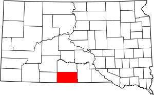
Location within the U.S. state of South Dakota
|
|
 South Dakota's location within the U.S. |
|
| Country | |
| State | |
| Founded | 1909 |
| Named for | John Blair Smith Todd |
| Seat | None (de jure) Winner (de facto) |
| Largest city | Mission |
| Area | |
| • Total | 1,391 sq mi (3,600 km2) |
| • Land | 1,389 sq mi (3,600 km2) |
| • Water | 2.3 sq mi (6 km2) 0.2% |
| Population
(2020)
|
|
| • Total | 9,319 |
| • Estimate
(2023)
|
9,199 |
| • Density | 6.6995/sq mi (2.5867/km2) |
| Time zone | UTC−6 (Central) |
| • Summer (DST) | UTC−5 (CDT) |
| Congressional district | At-large |
| Winner in neighboring Tripp County serves as Todd County's administrative center. | |
Todd County is a county located in the state of South Dakota in the United States. In 2020, about 9,319 people lived there.
Todd County is special because it does not have its own main office town, called a county seat. Instead, the town of Winner, which is in the next-door Tripp County, helps manage Todd County's paperwork and services. The biggest city in Todd County is Mission.
The county was created in 1909. It is still considered "unorganized," which means it doesn't have a fully independent local government like most counties. The county was named after John Blair Smith Todd. He was a representative from the Dakota Territory in the U.S. Congress and a general during the American Civil War.
Todd County is entirely within the Rosebud Indian Reservation. This means its borders are the same as the main reservation area. Its southern border touches the state of Nebraska. It is one of five counties in South Dakota that are completely inside an Indian reservation. The average income per person in Todd County is among the lowest in the United States. Unlike many rural areas in South Dakota, the number of people living in Todd County has actually grown since 1960.
Contents
History of Todd County
For a long time, until 1981, Todd County was one of the last "unorganized" counties in the United States. Two other counties, Shannon (now called Oglala Lakota) and Washabaugh, were also unorganized.
Even after it became more organized, Todd County didn't get its own "home rule charter" until 1983. A home rule charter is like a special permission that lets a county create its own local laws and manage its own affairs more independently.
Today, Todd County works with Tripp County for some important services. For example, Tripp County helps Todd County with its financial records (Auditor), money management (Treasurer), and official documents (Registrar of Deeds).
Geography of Todd County
Todd County is located in the southern part of South Dakota. Its southern edge borders the state of Nebraska. The land here has rolling hills and is somewhat dry. There are many small valleys and streams that flow towards the northeast.
Some of the land is used for farming, including a type of watering system called center pivot irrigation. The land generally slopes down towards the northeast. The highest point in the county is near its southwest corner, which is about 3,176 feet (968 meters) above sea level.
Most counties in eastern South Dakota use Central Time. Counties in western South Dakota use Mountain Time. Todd County is the most western county in South Dakota that observes Central Time.
Todd County covers a total area of about 1,391 square miles (3,603 square kilometers). Of this, 1,389 square miles (3,597 square kilometers) is land, and only about 2.3 square miles (6.0 square kilometers) is water.
Main Roads
Neighboring Counties
- Mellette County - to the north
- Tripp County - to the east
- Cherry County, Nebraska - to the south (part of this county uses Mountain Time)
- Keya Paha County, Nebraska - to the southeast
- Bennett County - to the west (uses Mountain Time)
- Jackson County - to the northwest (uses Mountain Time)
Special Areas
- Hollow Horn Bear Village
Lakes in Todd County
- Antelope Lake
- He Dog Lake
- White Lake
Population Information
| Historical population | |||
|---|---|---|---|
| Census | Pop. | %± | |
| 1910 | 2,164 | — | |
| 1920 | 2,784 | 28.7% | |
| 1930 | 5,898 | 111.9% | |
| 1940 | 5,714 | −3.1% | |
| 1950 | 4,758 | −16.7% | |
| 1960 | 4,661 | −2.0% | |
| 1970 | 6,606 | 41.7% | |
| 1980 | 7,328 | 10.9% | |
| 1990 | 8,352 | 14.0% | |
| 2000 | 9,050 | 8.4% | |
| 2010 | 9,612 | 6.2% | |
| 2020 | 9,319 | −3.0% | |
| 2023 (est.) | 9,199 | −4.3% | |
| U.S. Decennial Census 1790-1960 1900-1990 1990-2000 2010-2020 |
|||
2020 Census Details
According to the 2020 census, there were 9,319 people living in Todd County. There were 2,570 households (groups of people living together) and 1,889 families. The population density was about 6.7 people per square mile. There were also 2,875 housing units (homes or apartments).
2010 Census Details
In the 2010 census, there were 9,612 people, 2,780 households, and 2,091 families in the county. The population density was about 6.9 people per square mile.
Most of the people in the county were Native Americans (88.1%). About 9.6% were white, and smaller percentages were other races. About 2.4% of the people were of Hispanic or Latino background.
In 2010, 55.9% of households had children under 18 living with them. The average household had 3.45 people, and the average family had 3.95 people. The median age of people in the county was 24.0 years old.
The median income for a household was $25,196, and for a family, it was $29,010. The income per person in the county was $11,010. About 44.2% of families and 48.8% of all people in the county lived below the poverty line. This included 59.0% of those under 18 and 45.7% of those aged 65 or older.
Towns and Communities
City
Town
Census-Designated Places
These are areas that are like towns but are not officially incorporated as cities or towns.
- Antelope
- Okreek
- Parmelee
- Rosebud
- Sicangu Village
- Soldier Creek
- Spring Creek
- Two Strike
- White Horse
Other Unincorporated Communities
These are small communities that are not officially recognized as towns or cities.
- Grass Mountain
- HeDog
- Hidden Timber
- Olsonville
Unorganized Territories
These are parts of the county that do not have their own local government.
- East Todd
- West Todd
See also
 In Spanish: Condado de Todd (Dakota del Sur) para niños
 | Bayard Rustin |
 | Jeannette Carter |
 | Jeremiah A. Brown |

