
Bennett County, South Dakota facts for kids
Quick facts for kids
Bennett County
|
|
|---|---|
_from_S_1.JPG)
Art Deco style Inland Theater at Martin SD.
|
|

Location within the U.S. state of South Dakota
|
|
 South Dakota's location within the U.S. |
|
| Country | |
| State | |
| Founded | 1909 (created) April 27, 1912 (organized) |
| Named for | John E. Bennett or Granville G. Bennett |
| Seat | Martin |
| Largest city | Martin |
| Area | |
| • Total | 1,191 sq mi (3,080 km2) |
| • Land | 1,185 sq mi (3,070 km2) |
| • Water | 5.8 sq mi (15 km2) 0.5% |
| Population
(2020)
|
|
| • Total | 3,381 |
| • Estimate
(2023)
|
3,305 |
| • Density | 2.8388/sq mi (1.0961/km2) |
| Time zone | UTC−7 (Mountain) |
| • Summer (DST) | UTC−6 (MDT) |
| Congressional district | At-large |
Bennett County is a place in South Dakota, a state in the United States. In 2020, about 3,381 people lived there. The main town, where the county government is, is called Martin.
Long ago, this area was part of the Pine Ridge Indian Reservation. Even today, much of the land is still held in trust for the Native American tribes. To the east is the Rosebud Indian Reservation, home to the Sicangu Oyate, also known as the Rosebud Sioux Tribe. They are part of the Lakota people.
Bennett County is home to a special spot called the "North American continental pole of inaccessibility". This means it's the farthest place from any ocean in North America! It's about 1,650 kilometers (1,025 miles) from the nearest coast. This spot is located between Allen and Kyle.
For a long time, people in Bennett County mainly raised cattle (ranching) and grew crops without much rain (dry land farming). This was because of the weather and soil conditions.

Contents
History of Bennett County
This land has been the home of the Oglala Lakota people, also known as the Sioux, for many centuries. It became part of their official territory through a treaty in 1851. The land stayed within their legal boundaries even after other treaties changed their land to the current size of the Pine Ridge Indian Reservation in 1889.
Even though it was a reservation, most of the county was opened for new settlers in 1910. The U.S. Congress allowed the sale of land in Bennett County that was part of the Pine Ridge Indian Reservation. This open settlement ended in 1936, when the land was returned to tribal ownership. Because of these changes, the county's land is a mix of tribal trust lands and private lands.
Bennett County was officially created in 1909. Its land was taken from Fall River County. On April 27, 1912, the county's first leaders were chosen. In November 1912, the people living there chose the town of Martin to be the county seat.
Disputes Over Reservation Status
There have been different ideas about whether Bennett County is still part of the Pine Ridge Reservation. In 1975, a court said it was not part of the reservation. However, the U.S. government did not fully agree with this decision.
Other court cases have said that Bennett County is within the Pine Ridge Indian Reservation. For example, in 1957, a court ruled that Bennett County is inside the reservation created in 1889. In 2004, a judge decided that a piece of land in Bennett County could be returned to tribal ownership, confirming that the county is indeed within the reservation's boundaries.
People and Communities
Both Lakota and European American people have worked to improve their relationships in recent years. People often refer to themselves as full-bloods, mixed-bloods (usually Native American), and whites. People from different groups often marry each other, and they are working together more.
In the mid-1990s, people in the county held a powwow (a Native American gathering) and a rodeo at the same time. By the 1990s, most people living in the county were of Native American descent. In 2000, Bennett County had the highest percentage of people who identified as both Native American and European American in the U.S., outside of a few specific areas.
Bennett County was in the news in 2014 when a small community called Swett was put up for sale. The two people living there listed six acres of land and all the property for nearly $400,000. By 2016, the price was lowered to $250,000, but it still didn't sell.
Geography of Bennett County
Bennett County is located on the southern border of South Dakota. Its southern edge touches the northern edge of Nebraska. The Little White River flows east through the lower middle part of the county.
The highest point in the county is in the southwest corner, about 3,497 feet (1,066 meters) above sea level. The lowest point is along the northern border, about 2,703 feet (824 meters) above sea level. The land has rolling hills and valleys, sloping towards the east-northeast.
The county covers a total area of about 1,191 square miles (3,085 square kilometers). Most of this is land (1,185 square miles or 3,070 square kilometers), and a small part is water (5.8 square miles or 15 square kilometers).
Most counties in eastern South Dakota use Central Time, but Bennett County is one of the western counties that uses Mountain Time.
Main Roads
 U.S. Highway 18
 South Dakota Highway 73
Neighboring Counties
- Jackson County - north
- Mellette County – northeast
- Todd County - east
- Cherry County, Nebraska - south
- Sheridan County, Nebraska – southwest
- Oglala Lakota County - west
Protected Natural Areas
- Lacreek National Wildlife Refuge
- Little White River Recreation Area
- Little White River State Game Production Area
- Todd State Game Production Area
Population Information
| Historical population | |||
|---|---|---|---|
| Census | Pop. | %± | |
| 1910 | 96 | — | |
| 1920 | 1,924 | 1,904.2% | |
| 1930 | 4,590 | 138.6% | |
| 1940 | 3,983 | −13.2% | |
| 1950 | 3,396 | −14.7% | |
| 1960 | 3,053 | −10.1% | |
| 1970 | 3,088 | 1.1% | |
| 1980 | 3,044 | −1.4% | |
| 1990 | 3,206 | 5.3% | |
| 2000 | 3,574 | 11.5% | |
| 2010 | 3,431 | −4.0% | |
| 2020 | 3,381 | −1.5% | |
| 2023 (est.) | 3,305 | −3.7% | |
| U.S. Decennial Census 1790-1960 1900-1990 1990-2000 2010-2020 |
|||
2020 Census
In 2020, there were 3,381 people living in Bennett County. There were 1,085 households (groups of people living together) and 737 families. The population density was about 2.9 people per square mile. There were 1,177 homes.
2010 Census
In 2010, there were 3,431 people, 1,090 households, and 766 families in the county. The population density was about 2.9 people per square mile.
The people living in the county were:
- 61.5% American Indian
- 33.7% white
- 0.4% Asian
- 0.1% Pacific Islander
- 0.1% black or African American
- 0.2% from other races
- 4.0% from two or more races
About 2.0% of the people were of Hispanic or Latino origin.
Of the households, 42.9% had children under 18 living with them. The average household had 3.11 people, and the average family had 3.73 people. The average age of people in the county was 28.7 years old.
The average income for a household was $32,841, and for a family it was $38,487. About 32.1% of the total population lived below the poverty line. This included 42.3% of those under 18 years old.
Towns and Communities
Cities
- Martin (the county seat)
Census-Designated Places
Small Communities (Unincorporated)
Former Communities
Education
The Bennett County School District serves all of Bennett County.
The Bureau of Indian Education (BIE) works with the American Horse School. This school is for grades K-8 in Allen and is run by a tribal group.
Images for kids
-
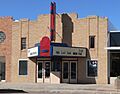
The Art Deco style Inland Theater in Martin, South Dakota.
See also
 In Spanish: Condado de Bennett para niños
