
Allen, South Dakota facts for kids
Quick facts for kids
Allen, South Dakota
Wagmíza Wakpála
|
|
|---|---|
|
CDP
|
|
 |
|

Location in Bennett County and the state of South Dakota
|
|

Allen, South Dakota
Location in the United States

Allen, South Dakota
Location in North America
|
|
| Country | United States |
| state | South Dakota |
| Counties | Bennett |
| Civil township | Allen Township |
| Area | |
| • Total | 3.9 sq mi (10 km2) |
| • Land | 3.9 sq mi (10 km2) |
| • Water | 0 sq mi (0 km2) 0% |
| Elevation | 3,297 ft (1,005 m) |
| Population
(2020)
|
|
| • Total | 460 |
| • Density | 107.7/sq mi (41.6/km2) |
| Time zone | UTC-7 (Mountain (MST)) |
| • Summer (DST) | UTC-6 (MDT) |
| ZIP code |
57714
|
| GNIS feature ID | 2393315 |
Allen is a small community in South Dakota, United States. It's located on the Pine Ridge Indian Reservation in Bennett County. The name Allen comes from the Allen Township, which covers the area. In the Lakota language, Allen is called Wagmíza Wakpála, which means "corn creek."
As of the 2020 census, about 460 people lived in Allen. It is also known for being one of the places closest to the North American continental pole of inaccessibility. This means it's one of the farthest spots from any ocean coastline on the continent.
Contents
History of Allen
The community of Allen is named after the Allen Township. This township was named after Charles W. Allen. He was the first merchant, or shop owner, in the town.
Geography and Location
Allen is a small place, covering about 3.9 square miles (10 square kilometers) of land. It does not have any water areas within its boundaries.
The ZIP code for Allen is 57714.
North America's Farthest Point
Allen is very close to a special spot in North America. This spot is called the "continental pole of inaccessibility." It's the place on the continent that is farthest from any ocean. This unique location is between Allen and another community called Kyle. It is about 1,650 km (1,025 miles) away from the nearest coastline.
Population Changes
| Historical population | |||
|---|---|---|---|
| Census | Pop. | %± | |
| 2000 | 419 | — | |
| 2010 | 420 | 0.2% | |
| 2020 | 460 | 9.5% | |
| U.S. Decennial Census | |||
Allen's Population in 2020
In 2020, there were 460 people living in Allen. There were 84 households, which are groups of people living together in one home. Most of the people in Allen were Native American, making up about 99% of the population. A small number were White or from two or more races. About 1.5% of the population identified as Hispanic or Latino.
Allen's Population in 2010
The census in 2010 showed that 420 people lived in Allen.
Allen's Population in 2000
In 2000, Allen had a population of 419 people. There were 80 households and 70 families. Many households, about 62.5%, had children under 18 living there. The average household had about 5 people.
The population was quite young. Over half, about 50.4%, were under 18 years old. The average age in Allen was 18 years.
Education in Allen
The Bureau of Indian Education (BIE) helps run the American Horse School in Allen. This school teaches students from kindergarten through 8th grade. A tribal group operates the school.
The American Horse School started in 1931. It was formed by combining two smaller schools. As of 2019, about 330 students attended the school.
In 2015, some people noted that the school building needed improvements. It had old insulation and was a bit crowded. It also needed better electrical and internet systems for modern learning.
Allen is part of the Bennett County School District 03-1.
Allen Youth Center
The Allen Youth Center opened in 2014. This center helps young people with many things. It offers tutoring to help with schoolwork. It also provides fun activities and distributes food to those who need it. Since 2018, the center has been powered by solar panels, which use energy from the sun.
Images for kids
-
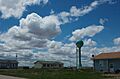
A view of Allen, South Dakota.
-
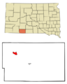
Map showing Allen's location in Bennett County, South Dakota.
See also
 In Spanish: Allen (Dakota del Sur) para niños
