
Pole of inaccessibility facts for kids

A pole of inaccessibility is a place on Earth that is the hardest to reach. It's usually the spot farthest from any coastline. Imagine drawing the biggest possible circle inside a land area or an ocean without touching any land. The center of that circle would be a pole of inaccessibility!
These spots are super remote. They are often found in the middle of continents or vast oceans. Scientists and explorers find them interesting because they are so challenging to get to.
Contents
Northern Pole of Inaccessibility

The Northern pole of inaccessibility, also called the Arctic pole, is found on the Arctic Ocean's floating ice. It's the point farthest from any land in the Arctic.
In 1927, Sir Hubert Wilkins thought he knew where it was. He wanted to fly across the Arctic Ocean, and he did so in 1928. Later, in 1968, Sir Wally Herbert tried to reach this spot by dogsled. He got very close but couldn't make it because the sea ice was moving.
In 2005, explorer Jim McNeill asked scientists to find the exact spot again using modern GPS and satellite tools. They found a new location for the pole. It is at 85°48′N 176°9′W. This spot is about 1,008 kilometers (626 miles) from the closest land. The closest lands are Henrietta Island, Arctic Cape on Severnaya Zemlya, and Ellesmere Island. Because the ice is always moving, no building can stay there permanently.
As of 2021, Jim McNeill believes no one has reached this new Arctic pole of inaccessibility by traveling across the ocean's surface from the last piece of land.
Southern Pole of Inaccessibility

The southern pole of inaccessibility is the point in Antarctica that is farthest from the Southern Ocean. Its exact location can be tricky to pinpoint. This is because the "coast" can be measured differently. Also, the ice sheets move, and survey data gets better over time.
This pole often refers to the site of an old Soviet Union research station. This station was built in 1958 at 82°06′S 54°58′E. It is about 878 kilometers (546 miles) from the South Pole. The station is at a high elevation of 3,718 meters (12,198 feet).
The southern pole of inaccessibility is much harder to reach than the geographic South Pole. In 1958, a Soviet team built a temporary station there. Another Russian team visited it again in 1967. Today, a building from the station is still there. It has a statue of Vladimir Lenin on top, facing towards Moscow. This site is now protected as a historical place.
On January 19, 2007, a team called N2i (made up of Henry Cookson, Rupert Longsdon, Rory Sweet, and Paul Landry) reached the old Soviet station. They were the first to get there without mechanical help. They used a mix of pulling their gear and kite skiing. They found that only Lenin's bust was visible; the rest of the building was buried under snow.
Another Spanish team, led by Ramón Hernando de Larramendi, reached a different calculated southern pole of inaccessibility on December 11, 2005. They also reached a second one, which considers ice shelves, on December 14, 2005. They used kites to travel very fast across the ice.
On December 27, 2011, Sebastian Copeland and Eric McNair-Laundry also reached the Soviet station's location. They were the first to do it without getting new supplies or mechanical help.
Because technology improves and the edge of Antarctica changes, the exact spot of this pole can vary. But for explorers, the old Soviet station is often used as a fixed goal.
Oceanic Pole of Inaccessibility

The oceanic pole of inaccessibility is the place in the ocean that is farthest from any land. It's in the South Pacific Ocean. This spot is about 2,688 kilometers (1,670 miles) from the nearest lands. These lands are Ducie Island, Motu Nui (near Easter Island), and Maher Island (near Antarctica).
This area is so remote that sometimes the closest people are astronauts. They are aboard the International Space Station when it flies overhead!
This special point is known as Point Nemo. "Nemo" means "no one" in Latin. It's also a nod to Jules Verne's famous character, Captain Nemo. This remote ocean area is also called a "spacecraft cemetery". This is where old satellites and space stations are sent to crash safely into the ocean. This way, they don't hit populated areas or ships. Point Nemo has very little life because it's so far from land. Not many nutrients reach this part of the ocean.
Continental Poles of Inaccessibility
Many continents also have their own poles of inaccessibility. These are the spots farthest from any ocean on that landmass.
Eurasia

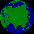
In Eurasia, the largest continent, the pole of inaccessibility is in northwestern China. It's near the border with Kazakhstan. This spot is about 2,510 to 2,645 kilometers (1,560 to 1,644 miles) from the nearest coastline. It's located in the Dzoosotoyn Elisen Desert, north of the city of Ürümqi.
Scientists have found a couple of slightly different locations for this pole. This is because how you define the coastline can change the exact spot. These points are close to the Dzungarian Gate. This area was an important path for people moving between East and West long ago.
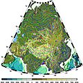
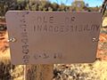
North America

In North America, the pole of inaccessibility is in southwest South Dakota. It's on the Pine Ridge Indian Reservation, about 11 kilometers (7 miles) north of the town of Allen. This spot is about 1,650 kilometers (1,025 miles) from the nearest coast. A special marker was placed there in 2021.
South America
In South America, the continental pole of inaccessibility is in Brazil. It's near Arenápolis, in the state of Mato Grosso. This point is about 1,504 kilometers (935 miles) from the nearest coastline. In 2017, the Turner Twins were the first adventurers to trek to this South American pole.
Australia

In Australia, the pole of inaccessibility is about 920 kilometers (572 miles) from the nearest coast. It's located west-northwest of Alice Springs. The closest town is Papunya, about 30 kilometers (19 miles) away.
Africa
In Africa, the pole of inaccessibility is near the town of Obo in the Central African Republic. It's close to where the borders of the Central African Republic, South Sudan, and the Democratic Republic of the Congo meet. This spot is about 1,814 kilometers (1,127 miles) from the coast.
Images for kids
-
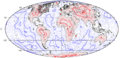
Map of distance to the nearest coastline (including oceanic islands, but not lakes) with red spots marking the poles of inaccessibility of main landmasses, Great Britain, and the Iberian Peninsula, and a blue dot marking the oceanic pole of inaccessibility. Thin isolines are 250 km apart; thick lines 1000 km. Mollweide projection.
-
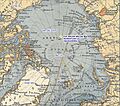
Northern pole of inaccessibility
-
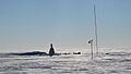
The old Soviet Pole of Inaccessibility Station, revisited by Team N2i on 19 January 2007
-
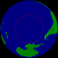
Oceanic pole of inaccessibility at 48° 52′ 32″S 123° 23′ 33″W
-
Proposed continental pole of inaccessibility at 46°17′N 86°40′E, ignoring the Caspian Sea
-
Distance to the sea in Asia, showing the two candidate locations for Eurasian pole of inaccessibility.
-
The North-West portion of the North American Pole of Inaccessibility.
-
Australian Pole of Inaccessibility

See also
 In Spanish: Polo de inaccesibilidad para niños
