
Ducie Island facts for kids

NASA photograph of Ducie Island
|
|
| Geography | |
|---|---|
| Location | South Pacific Ocean |
| Coordinates | 24°40′09″S 124°47′11″W / 24.66917°S 124.78639°W |
| Archipelago | Pitcairn Islands |
| Total islands | 4 |
| Major islands | Acadia, Pandora, Edwards, Westward |
| Highest elevation | 15 ft (4.6 m) |
| Administration | |


Ducie Island is a small, uninhabited atoll in the Pitcairn Islands. It is located east of Pitcairn Island and Henderson Island. The atoll covers a total area of about 1.5 square miles (3.9 km²), which includes its central lagoon. It is about 1.5 miles (2.4 km) long from northeast to southwest and about 1 mile (1.6 km) wide. Ducie Island is made up of four smaller islets: Acadia, Pandora, Westward, and Edwards.
Even though it doesn't have much plant life, Ducie Atoll is a very important place for many types of birds to breed. More than 90% of the world's population of Murphy's petrels nest here. Also, about 1% of the world's red-tailed tropicbirds and fairy terns make their homes on Ducie.
Ducie Island was first seen in 1606 by a Portuguese explorer named Pedro Fernandes de Queirós. He called it Luna Puesta. Later, in 1791, Captain Edward Edwards rediscovered it. He was the captain of the ship HMS Pandora, sent to find the sailors who mutinied on the famous HMS Bounty. Captain Edwards named the island Ducie to honor his friend, Francis Reynolds-Moreton, 3rd Baron Ducie. In 1867, the United States tried to claim the island, but the United Kingdom officially took control of it on December 19, 1902. Today, Ducie Island is rarely visited because it is far away and hard to reach.
Contents
Discovering Ducie Island
Who First Saw Ducie Island?
The island was first discovered by a Spanish group led by a Portuguese sailor, Pedro Fernandes de Queirós. This happened on January 26, 1606. His journey started in Callao, Peru. Queirós was in charge of three ships and was supported by Pope Clement VIII and Philip III of Spain. Their goal was to set up a new colony in the Santa Cruz Islands.
Ducie Island was the first of 18 new places Queirós found on his trip. He named it Luna Puesta, which means "moon that has set." On the same day, he also saw two other islands. These were named San Juan Bautista and La Encarnación. It is not clear which of these was Henderson Island and which was Pitcairn Island.
How Was Ducie Island Rediscovered?
Ducie Island was found again and given its current name on March 16, 1791. This was done by Captain Edward Edwards of HMS Pandora. He had been sent from Britain to arrest the sailors who mutinied on the Bounty. Edwards named the island after Francis Reynolds-Moreton, 3rd Baron Ducie, who he had worked with before. After leaving Ducie, HMS Pandora turned north. Because of this, Edwards did not see the other islands in the group, including Pitcairn Island, where the Bounty mutineers were hiding.
In November 1820, the crew of the whaling ship Essex thought they had reached Ducie Island. Their ship had been attacked and sunk by a whale. After a month at sea in small boats, they actually landed on Henderson Island by mistake. The first recorded landing on Ducie was in 1820 by Captain Thomas Raine of the ship Surrey. He was looking for the Essex survivors.
Frederick William Beechey arrived in HMS Blossom in November 1825. He wrote the first detailed description of Ducie Island. His group did not land on the atoll. However, crew members sailed around it in small boats. Based on Beechey's notes, the first official map of the island was made in 1826. This map was the only one available for almost 100 years.

The Shipwreck of the Acadia
On June 5, 1881, a mail ship called the Acadia crashed on Ducie Island. It was returning from San Francisco after delivering its cargo. The ship's captain, Stephen George, had planned a route that would pass 15 to 20 miles (24 to 32 km) east of Ducie. At 6 AM, the first mate was in charge. Half an hour later, he saw a white line in the water. He thought it was just light in the water. When he realized it was land, he tried to steer away, but it was too late. The lookout said he thought the white land was a cloud.
The crew tried to get the ship off the island but failed. The captain then sailed one of the ship's small boats to Pitcairn Island. The people there helped him. He returned on an American boat, the Edward O'Brien, to rescue the rest of his crew. A court later looked into the accident. They could not say for sure why the ship crashed. It might have been a mistake by the captain or an unknown ocean current. The court said the captain was not at fault. Today, a stone marker on Acadia Islet remembers the wreck. The ship's remains are still offshore in about 33 feet (10 meters) of water.
Modern Expeditions to Ducie
In 1969, Ducie Atoll was suggested as an "Island for Science." It was later recommended to be a Ramsar Site, which means it's an important wetland. Many scientific trips have visited the island to study its plants and animals. These include the Whitney South Seas Expedition in 1922 and the Smithsonian expedition in 1975. More recently, in 2012, explorer Enric Sala made a film called Sharks of Lost Island, which featured Ducie and the Pitcairn Islands. Because it's so hard to get to, Ducie is rarely visited. However, some cruise ships make one or two landings each year.
Who Owns Ducie Island?
Even though Captain Edward Edwards found Ducie Atoll in 1791, it was not immediately considered British property. In 1867, the United States claimed Ducie under the Guano Islands Act. This law said that an uninhabited place with guano (bird droppings used as fertilizer) could be claimed by the U.S. if no other country owned it. However, neither the U.S. nor the UK fully agreed on each other's claims. They both believed that just discovering an island wasn't enough to own it; a formal act of taking possession was needed. In the end, the United States did not strongly push its claims on most of these islands.
On December 19, 1902, the United Kingdom officially took control of Ducie Island. Captain G. F. Jones and some people from Pitcairn Island visited Ducie and added it to the UK's territory. This made Ducie part of the Pitcairn Islands.
On August 4, 1937, Captain J. W. Rivers-Carnac of HMNZS Leander confirmed British ownership of Ducie. He raised the Union Flag and put up signs saying the island belonged to King George VI. Ducie was one of several islands thought to be good spots for seaplane bases, but these plans never happened. Today, Ducie and the other Pitcairn Islands are ruled by a governor chosen by the British monarch.
What is Ducie Island Like?


Ducie Island is about 290 miles (470 km) east of Pitcairn Island. Some people say it is the southernmost atoll in the world. However, Middleton Reef is even further south, so this claim is likely incorrect. Ducie Island's land area is about 170 acres (69 hectares). Its highest point is on Westward Islet, reaching about 15 feet (4.6 meters) above sea level.
Ducie was formed about 8 million years ago. It is part of a chain of islands and underwater mountains. The atoll has a central lagoon. You can only enter it by boat through a channel about 100 yards (91 meters) wide. This channel is in the southwest, between Pandora and Westward Islets. The lagoon is up to 52 feet (16 meters) deep and has a bottom made of sand and coral. Sometimes, whirlpools form in the lagoon. These are caused by underwater caves that drain water from the lagoon into the ocean.
The Four Islets of Ducie
Ducie Atoll has four islets: Acadia, Pandora, Westward, and Edwards. Acadia is the largest. You can walk to the three smaller islets from Acadia at low tide. These islets were named by scientists Harald Rehder and John Randall in 1975.
- Acadia Islet is along the north and east edge of the atoll. It is much larger than the other three islets combined, covering about 140 acres (57 hectares). It is very long and thin, mostly covered in trees, and made of coral rubble. It is named after the ship Acadia, which was wrecked on Ducie in 1881.
- Pandora Islet is in the south and is the second largest. It is made of sand and coral rubble that borders the lagoon. It is named after the ship HMS Pandora.
- Edwards Islet is right next to Pandora Islet on the east side. It is similar to Pandora Islet. It is named after Edward Edwards, the captain of HMS Pandora.
- Westward Islet is west of Pandora Islet and is the smallest. From a distance, it looks sandy, but its ground is made of coral rubble and dead shells. Its highest point is about 15 feet (4.6 meters) above sea level. It is named after the ship Westward, which carried scientists on an expedition in 1970–71.
Plants and Animals of Ducie Island
Plant Life
There are not many plants on Ducie Atoll because there is little fresh water. Only two types of larger plants are known to grow there. This is one of the smallest plant lists for any island. Acadia, Pandora, and Edwards Islets have forests of Heliotropium foertherianum trees. Westward Islet does not have these trees. Another plant called Pemphis acidula has also been found on Ducie.
Bird Life
Ducie Island is very important for seabirds that come to breed there. No land birds live on the atoll. Birds that have been seen nesting on Ducie include the red-billed tropicbird, red-tailed tropicbird, fairy tern, great frigatebird, masked booby, and red-footed booby. Many types of gulls and petrels also live here.
The island is especially important for Murphy's petrels. More than 90% of all Murphy's petrels in the world breed on Ducie. About 3,000 pairs of Christmas shearwaters, which is about 5% of their world population, also live on the island. The red-tailed tropicbirds and fairy terns that breed on Ducie make up about 1% of the world's population for each species. The island has been named an Important Bird Area (IBA) by BirdLife International. This is mainly because of its large groups of Murphy's, herald, and Kermadec petrels, and Christmas shearwaters.
-

Murphy's petrel chick
-
Fairy tern
-

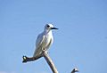
Red-tailed tropicbird
-

White tern chick


Fish and Other Animals
About 138 types of fish live in the lagoon. Some of these fish are also found in other parts of the Pacific and Indian Oceans. The lagoon is known for having some poisonous fish and dangerous sharks. For example, the yellow-edged lyretail and groupers can cause ciguatera poisoning if eaten. Galápagos sharks and whitetip reef sharks also live in the lagoon. Galápagos sharks can be dangerous to humans, but whitetip sharks usually are not unless bothered.
Five types of fish are found only around the Pitcairn Islands. These include a type of squirrelfish, the spiny butterflyfish, and a type of threefin blenny.
Lizards found on the island include the white-bellied skink. Another type of lizard, possibly a gecko, has also been seen. The only mammal known to live on Ducie is the Polynesian rat. In 1997, a successful project removed these rats from the island. This helped protect the bird species that the rats were threatening. Green sea turtles eat around Ducie, but they have not been seen breeding there.
See also
 In Spanish: Isla Ducie para niños
