Santa Cruz Islands facts for kids
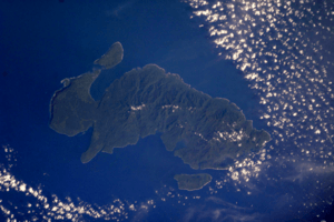
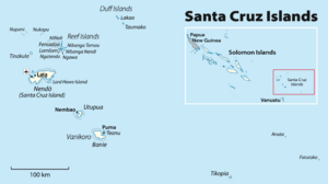
The Santa Cruz Islands are a group of islands found in the Pacific Ocean. They are part of the Solomon Islands, a country made up of many islands. These islands are located about 460 kilometers (250 nautical miles) southeast of the main Solomon Islands group. The Santa Cruz Islands are just north of Vanuatu, another island nation. They are known for their beautiful rainforests.


Contents
Geography of the Santa Cruz Islands
Sometimes, the name Santa Cruz Islands is used for all the islands in the Temotu Province of the Solomon Islands.
Main Islands
The biggest island in the group is Nendö. It is also called Santa Cruz Island itself. Nendö is about 505 square kilometers (195 square miles) in size. Its highest point is 549 meters (1,801 feet) above sea level. More than 5,000 people live on Nendö.
Lata is the largest town on Nendö. It is also the capital of Temotu Province.
Other important islands in the Santa Cruz group include Vanikoro and Utupua. Vanikoro is actually two islands, Banie and Teanu. Vanikoro covers about 173 square kilometers (67 square miles). Around 800 people live there. Utupua is about 69 square kilometers (27 square miles). It has a population of 848. The highest point on Utupua is 380 meters (1,247 feet) above sea level.
How the Islands Formed
The Santa Cruz Islands are quite young, less than five million years old. They were formed by tectonic plates moving. This is when huge pieces of the Earth's crust push against each other. The Indo-Australian Plate is moving north and sliding under the Pacific Plate. This movement pushed the islands upwards.
The islands are mostly made of limestone and volcanic ash. Limestone is a type of rock, and volcanic ash comes from volcanoes. The highest point in the Santa Cruz Islands is on Vanikoro, reaching 924 meters (3,031 feet).
Culture and Traditions
Languages Spoken
The people of the Santa Cruz Islands speak native languages. These languages are part of the Reef Islands – Santa Cruz languages group. This group belongs to the larger Austronesian language family. Many languages in the Pacific Ocean come from this family.
Tepukei: Amazing Canoes
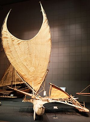
Some communities in the eastern Solomon Islands built special ocean-going canoes. These canoes are called Tepukei. They are outrigger canoes, meaning they have a support float on the side for stability.
In 1966, a German expert named Gerd Koch studied these canoes. He visited Graciosa Bay on Nendö Island and other nearby islands. He made films, took photos, and recorded sounds. Koch brought the last complete Tepukei from the Santa Cruz Islands to a museum in Berlin. He also wrote a book about the culture of the Santa Cruz Islands.
People from the Santa Cruz Islands were very skilled navigators. They used traditional techniques to find their way across the ocean. They did not use modern tools like compasses. Instead, they studied things like wave patterns and the stars.
In 1969, a navigator named Tevake helped David Henry Lewis on his boat. Tevake navigated from Taumako to Fenualoa, a distance of about 90 kilometers (50 miles). He used only traditional methods, even when clouds hid the stars. On another trip, Tevake used stars, waves, and even the glow of tiny sea creatures to find islands.
History and Contact with Other Cultures
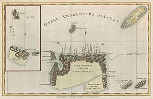
The first European to see these islands was a Spanish explorer. His name was Álvaro de Mendaña de Neira. He visited the islands during his second trip across the Pacific in 1595.
Mendaña tried to start a colony on Nendö Island. He named the colony "Santa Cruz." The place where he tried to settle was called Graciosa Bay. Mendaña sadly died there in 1596.
World War II in the Islands
During World War II, there was a big naval battle near these islands. It was called the Battle of the Santa Cruz Islands. This battle happened north of the island group.
Some United States Navy seaplanes were based in Graciosa Bay. Seaplanes are aircraft that can land on water. One seaplane reportedly sank at the base there. A U.S. Navy squadron, known as the "Seahawks," operated their Consolidated PBY Catalina flying boats from Graciosa Bay. They even flew "Black Cat" night missions. Some old supplies stored on Vanikoro Island during the war were not fully removed until the 1990s.
2013 Earthquake and Tsunami
The Santa Cruz Islands were hit by a strong earthquake on February 6, 2013. After the earthquake, a tsunami followed. A tsunami is a giant ocean wave caused by earthquakes.
The tsunami was about 1 meter (3 feet) high in Lata. It reached about 500 meters (1,600 feet) inland. The airport and low-lying areas were flooded. Sadly, some people lost their lives. More than 100 houses on the island were damaged. Water and electricity services were also stopped. Many homes in Nela village were washed away. Some homes in Venga village were moved by the powerful water.
See also
- In Spanish: Islas Santa Cruz para niños
- Melanesia
- Oceania
- Pacific Islands
 | William M. Jackson |
 | Juan E. Gilbert |
 | Neil deGrasse Tyson |


