
Central African Republic facts for kids
Quick facts for kids
Central African Republic
|
|
|---|---|
 Coat of arms
|
|
|
Motto:
|
|
|
Anthem:
|
|
.svg) Show globe Show globe Show map of Africa Show map of Africa |
|
| Capital and largest city
|
Bangui 4°22′N 18°35′E / 4.367°N 18.583°E |
| Official languages | French · Sango (co-official) |
| Recognised national languages |
|
| Ethnic groups |
|
| Religion
(2020)
|
|
| Demonym(s) | Central African |
| Government | Unitary presidential republic |
| Faustin-Archange Touadéra | |
| Félix Moloua | |
|
• President of the National Assembly
|
Simplice Sarandji |
| Legislature | National Assembly |
| Independence | |
|
• Republic established
|
1 December 1958 |
|
• from France
|
13 August 1960 |
|
• Central African Empire established
|
4 December 1976 |
|
• Coronation of Bokassa I
|
4 December 1977 |
| 21 September 1979 | |
| Area | |
|
• Total
|
622,984 km2 (240,535 sq mi) (44th) |
| Population | |
|
• 2024 estimate
|
5,650,957 (119th) |
|
• Density
|
7.1/km2 (18.4/sq mi) (221st) |
| GDP (PPP) | 2023 estimate |
|
• Total
|
|
|
• Per capita
|
|
| GDP (nominal) | 2023 estimate |
|
• Total
|
|
|
• Per capita
|
|
| Gini (2021) | ▼ 43 medium |
| HDI (2022) | low · 191st |
| Currency | |
| Time zone | UTC+1 (WAT) |
| Date format | dd/mm/yyyy |
| Driving side | right |
| Calling code | +236 |
| ISO 3166 code | CF |
| Internet TLD | .cf |

The Central African Republic (CAR) is a country in Central Africa. It is a landlocked nation, meaning it has no coastline. Most of the country is a high, flat area called a plateau, about 941 meters (3,087 feet) above sea level. The CAR covers about 620,000 square kilometers (240,000 square miles). In 2008, its population was estimated to be around 4.4 million people. The capital city is Bangui.
In the southern part of the country, there are thick forests. These forests are home to amazing animals like gorillas. Some Pygmy groups also live in this part of Africa.
Other important towns in the CAR include Bouar, Zinga, and Ouadda. The Ubangi River forms the country's southern border. Most people in the CAR belong to the Banda and Baya tribes. While French is an official language, many people also speak Sango, which is the national language.
Many people in the CAR grow their own food. However, sometimes long periods without rain, called droughts, make farming difficult. The country also has mines where diamonds and uranium are found. The CAR sells these, along with cotton, coffee, and wood, to other countries to earn money.
The currency used in the Central African Republic is the CFA Franc. The country was under the rule of France until 1960, when it became an independent nation.
Contents
History of the Central African Republic
Early History and Farming
About 10,000 years ago, the land became very dry, like a desert. This forced groups of hunter-gatherers to move south into Central Africa. Some of these groups settled down and started farming. This was part of the Neolithic Revolution, a time when people began to grow their own food.
At first, they farmed white yam. Later, they started growing millet and sorghum. Before 3000 BCE, people also began to grow African oil palm. This helped them get more food and allowed their communities to grow. People also started fishing and using boats to move goods, often in ceramic pots.
Ancient Times and Ironwork
In the western part of the country, there are large stone structures called the Bouar Megaliths. These show that advanced groups lived here around 3500–2700 BCE. Around 1000 BCE, people in the region learned how to work with iron.
The Ubangian people settled along the Ubangi River. This area is now the Central and East Central African Republic. Some Bantu people also moved into the region from the southwest.
Trade and Kingdoms
Bananas arrived in the region about 2,000 years ago. They became an important food source. People also used bananas to make alcoholic beverages. Trade was important, with goods like copper, salt, dried fish, and textiles being exchanged.
In the 16th and 17th centuries, slave traders started taking people from the region. These captives were sent to different parts of the world. In the 18th century, the Bandia-Nzakara Azande people created the Bangassou Kingdom along the Ubangi River. Later, the Bobangi people became major slave traders.
In 1875, a Sudanese sultan named Rabih az-Zubayr took control of the Upper-Oubangui area, which included what is now the Central African Republic.
European Rule and Independence
European countries began to take over parts of Africa in the late 1800s. This was called the Scramble for Africa. French, German, and Belgian explorers arrived in the area in 1885. France took control of the Ubangi-Shari territory in 1894 and made it a colony.
During this time, private companies were given permission to take resources like rubber and coffee from the land. Local people were forced to work without pay. If they didn't meet their work goals, their families could be held hostage.
In the 1920s and 1930s, the French made people grow cotton. They also built roads and tried to stop diseases like sleeping sickness. Many people from Ubangi were forced to work on the Congo-Ocean Railway. This was a very difficult and dangerous job.
After many years, the Central African Republic gained its independence from France in 1960.
Recent Times
After independence, the country faced challenges. There were calls for democracy in the 1990s. In 1993, the first multi-party elections were held, and Ange-Félix Patassé became president. However, the country has faced periods of conflict and instability since then.
Geography of the Central African Republic


The Central African Republic is a landlocked country in the middle of Africa. It shares borders with Cameroon, Chad, Sudan, South Sudan, the Democratic Republic of the Congo, and the Republic of the Congo. The country is located between 2° and 11°N latitude, and 14° and 28°E longitude.
Most of the country is a flat or gently rolling savanna plateau. It is about 500 meters (1,640 feet) above sea level. There are some scattered hills in the southwest. In the northwest, you can find the Yade Massif, which is a granite plateau.
The Central African Republic is the 44th largest country in the world by land area. It covers about 622,984 square kilometers (240,534 square miles).
Many rivers form the southern border of the country. These rivers are branches of the Congo River. The Mbomou River in the east joins with the Uele River to form the Ubangi River. The Sangha River flows through the western parts of the country.
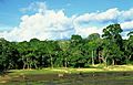
About 8% of the country is covered by forests. The thickest forests are in the southern regions. These forests have many different types of trees.
Climate

The Central African Republic generally has a tropical climate. There is a wet season that lasts from June to September in the north. In the south, the wet season is from May to October. During this time, it rains almost every day, and there is often fog in the mornings.
The northern areas are hot and humid from February to May. They can also experience the Harmattan, which is a hot, dry, and dusty wind. The southern regions have a climate that is more like areas near the equator.
Biodiversity and Wildlife

In the southwest, you'll find the Dzanga-Sangha National Park. This park is in a rain forest area. The country is known for its populations of forest elephants and western lowland gorillas.
In the north, the Manovo-Gounda St Floris National Park has many wild animals. These include leopards, lions, cheetahs, and rhinos. The Bamingui-Bangoran National Park is in the northeast. Sadly, these parks have been affected by poachers, especially from Sudan.
About 36% of the country is covered by forest. In 2021, the rate of deforestation in the Central African Republic increased.
Regions and Cities
The Central African Republic is divided into 14 main regions called prefectures. There are also two special economic prefectures and one independent city. These prefectures are further divided into 71 smaller areas.
The prefectures are:
- Bamingui-Bangoran
- Basse-Kotto
- Haute-Kotto
- Haut-Mbomou
- Kémo
- Lobaye
- Mambéré-Kadéï
- Mbomou
- Nana-Mambéré
- Ombella-M'Poko
- Ouaka
- Ouham
- Ouham-Pendé
- Vakaga
The two economic prefectures are Nana-Grébizi and Sangha-Mbaéré. The independent city is Bangui, which is also the capital.
Major Cities
Here are the largest cities in the Central African Republic, based on a 2006 census:
- Bangui - 622,771 people
- Bimbo - 124,176 people
- Berbérati - 76,918 people
- Carnot - 45,421 people
- Bambari - 41,356 people
- Bouar - 40,303 people
- Bossangoa - 36,478 people
- Bria - 35,204 people
- Bangassou - 31,553 people
- Nola - 29,181 people
Government and Politics

The Central African Republic has a presidential republic. This means the President is the head of the country. The Prime Minister is the head of the government.
Executive Branch
The President is chosen by the people in an election and serves for six years. The President then chooses the Prime Minister. The President also leads the Council of Ministers, which helps make laws and run the government.
Legislative Branch
The country's law-making body is called the National Assembly. It has 140 members. These members are elected for five-year terms.
Judicial Branch
The legal system in the Central African Republic is based on French law. The highest court is the Supreme Court, called the Cour Suprême. Its judges are chosen by the President. There is also a Constitutional Court, and its judges are also chosen by the President.
Economy and Trade
.svg)


The average income per person in the Central African Republic is one of the lowest in the world. However, this number often doesn't include money made from selling local foods, drinks, diamonds, and other goods that are not officially recorded.
The currency used is the CFA franc. This currency is used in several former French colonies in Africa. It has a fixed value compared to the euro. Diamonds are the most important export for the country. They make up 40–55% of the money earned from exports.
Farming is very important. People grow food crops like cassava, peanuts, maize, sorghum, millet, sesame, and plantain. These food crops are more important to the people's income than crops grown for export, like cotton or coffee. Many people in the country grow enough food for themselves.
The Central African Republic buys most of its goods from France, the United States, India, and China. It sells most of its exports to France, Burundi, China, Cameroon, and Austria.
People and Culture
Population and Ethnic Groups

The population of the Central African Republic has grown a lot since it became independent. In 1960, there were about 1.2 million people. Today, the population is estimated to be around 5.6 million.
The country is home to over 80 different ethnic groups. Each group has its own language. Some of the largest groups include the Baggara Arabs, Baka, Banda, Bayaka, Fula, and Gbaya. There are also people of European descent, mostly from France.
Languages

The Central African Republic has two official languages: French and Sango. Sango is a creole language that developed from the local Ngbandi language. It is used by many different ethnic groups to communicate. The Central African Republic is one of the few African countries that has made an African language an official language.
Religion
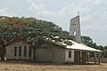
According to a 2003 census, most people in the Central African Republic are Christian. About 80% of the population follows Christianity, with many being Protestant or Roman Catholic. About 10% of the population is Muslim. Some people also follow traditional African faiths.
Many missionary groups work in the country. These groups come from places like the United States, France, and other African countries. During times of trouble, religious leaders have helped bring communities together and offered safe places for people.
Education

Public education in the Central African Republic is free. Children must go to school from ages 6 to 14. However, about half of the adults in the country cannot read or write. The country has two main places for higher education: the University of Bangui and Euclid University.
Culture and Sports
Culture

The Central African Republic has a rich culture, influenced by its many ethnic groups.
Sports
Football is the most popular sport in the country. The national football team plays its games at the Barthélemy Boganda Stadium.
Basketball is also very popular. The country's national team has won the African Championship twice. They were also the first team from Sub-Saharan Africa to qualify for the Basketball World Cup in 1974.
Related pages
- The Central African Republic at the Olympics
- Central African Republic national football team
- List of rivers of the Central African Republic
 |
Cameroon | Chad | Sudan | |
| Cameroon | South Sudan | |||
| Republic of the Congo | Democratic Republic of the Congo | Democratic Republic of the Congo |
Images for kids
-
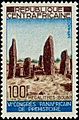
The Bouar Megaliths, pictured here on a 1967 Central African stamp, date back to the very late Neolithic Era (c. 3500–2700 BCE).
-
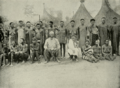
The Sultan of Bangassou and his wives, 1906
-
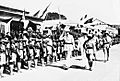
Charles de Gaulle in Bangui, 1940.
-
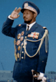
Jean-Bédel Bokassa, self-crowned Emperor of Central Africa
-
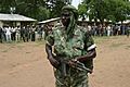
Rebel militia in the northern countryside, 2007.
-
Refugees of the fighting in the Central African Republic, January 2014
-
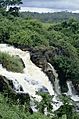
Falls of Boali on the Mbali River
-
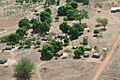
A village in the Central African Republic
-
Dzanga-Sangha Reserve
-
A Christian church in the Central African Republic
-
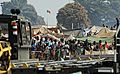
Trucks in Bangui
-
Mothers and babies aged between 0 and 5 years are lining up in a Health Post at Begoua, a district of Bangui, waiting for the two drops of the oral polio vaccine.


_-_Eglise_de_brousse_1.jpg)


See also
 In Spanish: República Centroafricana para niños
