
Rosebud Indian Reservation facts for kids
Quick facts for kids
Rosebud Sioux Indian Reservation
|
||
|---|---|---|
|
||

Location in South Dakota
|
||
| Tribe | Rosebud Sioux Tribe | |
| Country | United States | |
| State | South Dakota | |
| Counties | Gregory Lyman Mellette Todd (all) Tripp |
|
| Established | 1889 | |
| Headquarters | Rosebud | |
| Government | ||
| • Body | Rosebud Sioux Tribal Council | |
| Area | ||
| • Total | 5,103.214 km2 (1,970.362 sq mi) | |
| Population
(2017)
|
||
| • Total | 11,354 | |
| • Density | 2.22487/km2 (5.76239/sq mi) | |
| Time zone | UTC-6 (CST) | |
| • Summer (DST) | UTC-5 (CDT) | |
| Website | rosebudsiouxtribe-nsn.gov | |

The Rosebud Indian Reservation (RIR) is a special area of land in South Dakota, United States. It is the home of the Sicangu Oyate (the Upper Brulé Sioux Nation), also known as Sicangu Lakota. These people are part of the Lakota people. The Lakota name Sicangu Oyate means "Burnt Thigh Nation" in English. People also use the French name "Brulé Sioux".
The Rosebud Indian Reservation was created in 1889. This happened after the United States divided a much larger area called the Great Sioux Reservation. That bigger reservation was set up in 1868 by a special agreement called the Treaty of Fort Laramie. It used to cover a huge part of South Dakota, plus parts of Nebraska and Montana. Over time, the Rosebud Reservation, like other Sioux reservations, has become smaller. Today, it includes Todd County, South Dakota and parts of four nearby counties.
Contents
Where is the Rosebud Reservation?
The Rosebud Indian Reservation is in south-central South Dakota. It includes all of Todd County. The Oyate (the people) also live and own land in four nearby counties. These counties are Tripp, Lyman, Mellette, and Gregory. A large part of Mellette County is trust land for the tribe. Many Sicangu Oyate people live there.
The reservation and its trust lands cover about 1,970 square miles (5,103 square kilometers). In 2000, about 10,469 people lived there. The main part of the reservation (Todd County) is about 1,388 square miles (3,595 square kilometers). It had a population of 9,050 in 2000. The reservation is next to Cherry County, Nebraska to the south. To the west is the Pine Ridge Indian Reservation. The White River is to the north. Long ago, the Missouri River was its eastern border.
Main Towns and Nature
The main town and capital of the Oyate is Rosebud, South Dakota. This town was started when the Spotted Tail Indian Agency moved there. The agency was named after a famous 19th-century war chief, Sinte Gleska. The largest town on the reservation is Mission, South Dakota. It is located where US Highways 18 and 83 meet.
Nearby Mission is Antelope. This is one of many communities that grew from tribal groups in the late 1870s. Another important town is Saint Francis. It is home to the Saint Francis Indian School. This is a private Catholic school that started as a mission. Saint Francis has about 2,000 people. It is the largest town in South Dakota without a state highway for access.
The Rosebud Indian Reservation is on the Great Plains. It is just north of the Nebraska Sandhills. The area has large forests of Ponderosa Pine trees mixed with grasslands. There are deep valleys with steep hills and ravines. Often, lakes can be found in the deeper valleys.
Economy and Services
The biggest employers on the reservation are the Rosebud Sioux Tribe, the Bureau of Indian Affairs, and the Todd County School District. The Rosebud Sioux Tribe owns and runs the Rosebud Casino. It is on U.S. Route 83, just north of the Nebraska border. Near the casino is a gas station and convenience store.
The casino gets some of its power from a wind turbine. This is one of the first wind turbines owned by a tribe. In the early 2000s, the tribe built a new neighborhood called Sicangu Village. It is located near the casino and the state line.
The Tribe also owns QCredit, an online company that offers financial services. They work with a company called Think Finance. This company helps them with rules, managing risks, and loan services.
Wolakota Buffalo Range
The Wolakota Buffalo Range is a huge area of native grassland. It is about 28,000 acres (11,331 hectares) and is home to a bison herd. The Rosebud Economic Development Corporation (REDCO) manages this land. REDCO is the business part of the Rosebud Sioux Tribe. The bison herd was started in 2020. It helps with restoring nature, cultural practices, and getting food for the community. It also helps with teaching people about the bison.
How the Rosebud Sioux Tribe is Governed
The Rosebud Sioux Tribe (RST) is officially recognized by the government. In 1934, they started to govern themselves again under the Indian Reorganization Act. They created their own rules and a way to run their government. This helped them take back control from the Bureau of Indian Affairs (BIA). They chose a government with a president, vice-president, and a council of representatives. Many Native American nations use this type of government.
However, some tribal members did not like this new system. They preferred their old way of choosing leaders. Traditionally, they had hereditary clan chiefs. These chiefs were chosen for life, with approval from women elders. Their tribal council made decisions by talking until everyone agreed.
Both women and male elders still have a lot of influence in the nation. This is especially true for those who follow more traditional ways of life. Sometimes, there are groups with different ideas about how to govern. Some Sioux people who follow traditional ways support the old system. Others, who might have mixed backgrounds or more experience with city life, support the elected government.
Elected officials serve for only two years. This can make it hard for them to finish big projects. Also, BIA officials and police still have roles on the reservations. Some historians call this a form of "indirect colonialism."
Government Structure
- Laws: The tribe has a charter, constitution, and bylaws. These were approved on November 23, 1935.
- Governing Body: The Rosebud Sioux Tribal Council has 20 members.
- Leaders: The main leaders are the President, Vice-President, Secretary, Treasurer, and Sergeant-At-Arms.
Elections and Meetings
- Elections: Primary elections are on the fourth Thursday of August. General elections are on the fourth Thursday of October.
- Terms: The President and Vice-President are elected by all members for two-year terms. The Tribal Council members are elected from their districts every two years. The Council chooses the secretary, treasurer, and sergeant-at-arms.
- Districts: There are 13 election districts.
- Representatives: There is one representative for every 750 members.
- Council Meetings: Meetings happen twice a month, on Wednesdays and Thursdays.
- Quorum: At least 11 members must be present for a meeting to happen.
- Broadcast: Meetings are shown locally on Goldenwest Channel 93 and on the Rosebud Sioux Tribe YouTube Channel.
Education and Learning
The tribe has its own university on the reservation called Sinte Gleska University. This tribal university is named after the 19th-century Sioux war chief and leader, Spotted Tail.
- St. Francis Indian School (Sicangu Oyate Ho, Inc.) is in Saint Francis. It is a private Catholic school that started as a mission.
- St. Joseph's Indian School is in Chamberlain, South Dakota.
- Todd County High School is in Mission, South Dakota. You can find more about their schools at the Todd County School District 66-1 website.
- White River School District K-12 is in White River, South Dakota.
- Akta Lakota Museum & Cultural Center opened in 1991. It is on the campus of St. Joseph's Indian School. It teaches about Lakota culture.
Notable People from the Rosebud Tribe
- Notable Rosebud tribal members include:
-
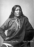
Chief Spotted Tail,
Brulé Lakota Leader -
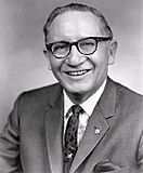
Ben Reifel "Lone Feather",
U.S. Representative, first Lakota Indian member of Congress. -
Janeen Antoine (Sicangu Lakota), curator, educator, and director of American Indian Contemporary Arts in San Francisco, grew up on the Rosebud Reservation.


- Susan Allen: The first Native American woman elected to the Minnesota state legislature.
- Janeen Antoine (Sicangu Lakota): A curator and educator. She started American Indian Contemporary Arts in San Francisco in 1983.
- Martin Brokenleg: A psychologist and author who writes about trauma and Native American studies.
- Belva Cottier (1920-2000): An activist and social worker. She helped plan the 1964 Occupation of Alcatraz.
- Paul Eagle Star (1864-1891): A Brulé Sioux member of Buffalo Bill's Wild West Show.
- Troy Heinert: A politician, businessman, and rodeo rider. He serves in the South Dakota Senate.
- Chief Iron Shell: He led the Brulé Orphan Band during the Powder River War (1866–1868).
- Joseph M. Marshall III: A Lakota historian and writer.
- Terry L. Pechota: An American attorney who was a U.S. Attorney for South Dakota.
- Benjamin "Ben" Reifel (1906-1990): A five-term U.S. Congressman. He was the first Lakota Indian member of Congress.
- Yvette Roubideaux: The first woman to be Director of the United States Indian Health Service (IHS).
- Chief Sinte Gleska (1823-1881): A war chief who later worked for peace. Sinte Gleska University is named after him.
- Richard Twiss (1954-2013): Founder of Wiconi International ministry.
- Frank Waln: A Sicangu Lakota rapper.
- Albert White Hat Sr.: An author, language teacher, and leader.
- Dyani White Hawk (born 1976): A Sicangu artist and former curator.
- Chauncey Yellow Robe (1867-1930): An educator, lecturer, and Native American activist.
Communities of the Rosebud Reservation
The Rosebud Sioux Reservation has 20 communities. Each of these communities has a representative on the tribal council:
- Antelope
- Okreek
- Parmelee
- Rosebud
- Saint Francis
- Spring Creek
- Two Strike
- Milks Camp
- Corn Creek
- Butte Creek
- Soldier Creek
- Upper Cut Meat
- Ring Thunder
- Black Pipe
- Bull Creek
- Swift Bear
- Grass Mountain
- Ideal
- He Dog
- Horse Creek
See also
 In Spanish: Reserva india Rosebud para niños
