Mellette County, South Dakota facts for kids
Quick facts for kids
Mellette County
|
|
|---|---|

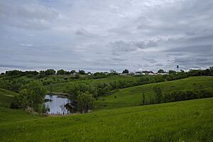
White River from the West, the county seat
|
|

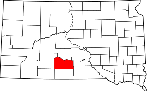
Location within the U.S. state of South Dakota
|
|
 South Dakota's location within the U.S. |
|
| Country | |
| State | |
| Founded | 1909 (created) 1911 (organized) |
| Named for | Arthur C. Mellette |
| Seat | White River |
| Largest city | White River |
| Area | |
| • Total | 1,311 sq mi (3,400 km2) |
| • Land | 1,307 sq mi (3,390 km2) |
| • Water | 3.6 sq mi (9 km2) 0.3% |
| Population
(2020)
|
|
| • Total | 1,918 |
| • Estimate
(2023)
|
1,851 |
| • Density | 1.4630/sq mi (0.5649/km2) |
| Time zone | UTC−6 (Central) |
| • Summer (DST) | UTC−5 (CDT) |
| Congressional district | At-large |
Mellette County is a place in the state of South Dakota, USA. A county is like a smaller area within a state. In 2020, about 1,918 people lived here.
The main town and government center of the county is White River. Mellette County was officially created in 1909 and started operating in 1911. It was named after Arthur C. Mellette. He was the last governor of the Dakota Territory and the first governor of South Dakota.
Long ago, this area was home to the Sioux and Lakota tribes. Today, about one-third of the county's land is special "trust land." This land is connected to the Rosebud Indian Reservation. This reservation is located in the county next door. Many people living in Mellette County are Native American. Most are from the Sicangu Oyate (Upper Brulé Sioux) and the Rosebud Sioux Tribe.
Contents
Exploring Mellette County's Geography
Mellette County is a place with rolling hills and open land. The White River flows along the northern edge of the county. Another river, the Little White River, runs through the middle. It eventually joins the White River.
The land here is mostly used for farming. The highest point in the county is about 2,779 feet (847 meters) above sea level. Mellette County covers about 1,311 square miles (3,395 square kilometers). Most of this area is land, with a small part being water.
Time Zones and Location
South Dakota uses two different time zones. Most counties in the eastern part of the state use Central Time. Counties in the western part use Mountain Time. Mellette County is the westernmost county in South Dakota that observes Central Time.
Major Roads in Mellette County
You can travel through Mellette County using these important highways:
Counties Nearby Mellette County
Mellette County shares its borders with several other counties:
- Jones County - to the north
- Lyman County - to the northeast
- Tripp County - to the east
- Todd County - to the south
- Bennett County - to the southwest (this county uses Mountain Time)
- Jackson County - to the west (this county also uses Mountain Time)
People of Mellette County
| Historical population | |||
|---|---|---|---|
| Census | Pop. | %± | |
| 1910 | 1,700 | — | |
| 1920 | 3,850 | 126.5% | |
| 1930 | 5,293 | 37.5% | |
| 1940 | 4,107 | −22.4% | |
| 1950 | 3,046 | −25.8% | |
| 1960 | 2,664 | −12.5% | |
| 1970 | 2,420 | −9.2% | |
| 1980 | 2,249 | −7.1% | |
| 1990 | 2,137 | −5.0% | |
| 2000 | 2,083 | −2.5% | |
| 2010 | 2,048 | −1.7% | |
| 2020 | 1,918 | −6.3% | |
| 2023 (est.) | 1,851 | −9.6% | |
| U.S. Decennial Census 1790-1960 1900-1990 1990-2000 2010-2020 |
|||
The population of Mellette County has changed over the years. In 2020, there were 1,918 people living in the county. There were 651 households, which are groups of people living together.
A Look at the 2010 Census
In 2010, the county had 2,048 people. About 54.1% of the people were American Indian. About 39.7% were white. A small number of people were from other racial backgrounds. About 1.5% of the population was of Hispanic or Latino origin.
Many families in Mellette County had children under 18 living with them. The average household had about 2.88 people. The average age of people in the county was 34.2 years old. The average income for a family was around $35,781.
Communities in Mellette County
Mellette County has different types of communities:
City
- White River (This is the county seat, where the main government offices are.)
Town
Census-Designated Places
These are areas that are like towns but are not officially incorporated:
- Corn Creek
- Horse Creek
- Norris
Unincorporated Communities
These are small settlements without their own local government:
- Mosher
Townships
Townships are smaller divisions of the county:
- Bad Nation
- Blackpipe
- Butte
- Cody
- Fairview
- Mosher
- New Surprise Valley
- Norris
- Prospect
- Red Fish
- Ring Thunder
- Riverside
- Rocky Ford
- Rosebud
- Running Bird
- Surprise Valley
Unorganized Territories
These areas do not have a local government structure like townships:
- Cedarbutte
- Central Mellette
See also
 In Spanish: Condado de Mellette para niños
 | DeHart Hubbard |
 | Wilma Rudolph |
 | Jesse Owens |
 | Jackie Joyner-Kersee |
 | Major Taylor |

