
U.S. Route 83 facts for kids
Quick facts for kids
|
|
|---|---|
 |
|
| Route information | |
| Length | 1,885 mi (3,034 km) |
| Existed | 1926–present |
| Major junctions | |
| South end | Veterans International Bridge at Los Tomates to Fed. 101 / Fed. 180 at the Mexico–United States border in Brownsville, TX |
|
|
| North end | |
| Location | |
| States: | Texas, Oklahoma, Kansas, Nebraska, South Dakota, North Dakota |
| Highway system | |
| United States Numbered Highways List • Bannered • Divided • Replaced |
|


U.S. Route 83 (US 83) is a very long road in the central United States. It is a major U.S. Highway that goes from north to south. The highway is about 1,885 miles (3,034 km) long. This makes it one of the longest north-south highways in the country!
US 83 starts in Harlingen, Texas, near the border with Mexico. It then travels all the way north to Westhope, North Dakota. There, it reaches the border with Canada. This means you can drive on US 83 from Mexico to Canada!
Contents
Where Does US 83 Go?
US 83 crosses six different states as it travels across the country. It starts in the warm state of Texas. Then it goes through Oklahoma, Kansas, and Nebraska. After that, it enters South Dakota and finally ends in North Dakota.
Texas: The Southern Start
In Texas, US 83 begins near the Mexico–United States border. It passes through many towns and cities. It even crosses paths with major highways like I-35 and I-10. As you drive, you can see different landscapes, from busy cities to quiet countryside.
Crossing the Great Plains
After Texas, US 83 goes through Oklahoma, Kansas, and Nebraska. These states are part of the Great Plains. Here, the road often runs straight through wide-open spaces. You might see lots of farms and fields. It crosses I-40 in Oklahoma and I-70 in Kansas. In Nebraska, it meets I-80.
The Dakotas: Heading North
Finally, US 83 enters South Dakota and North Dakota. These states are known for their beautiful prairies and colder winters. In South Dakota, it crosses I-90. In North Dakota, it meets I-94 and other important roads like US 2. The journey ends near Westhope, North Dakota, right at the Canadian border.
Fun Facts and Sights
Driving on US 83 is like taking a trip through different parts of America. You can see many interesting things along the way.
- In Texas, you might see the Texas Hill Country. This area has rolling hills and beautiful scenery.
- As you go north, you'll pass through the Nebraska Sandhills. This is a unique area with grassy dunes.
- The highway connects many small towns. It also goes through bigger cities like Abilene and Bismarck.
- US 83 is sometimes called "The Road to Nowhere" or "The Last American Highway." This is because it goes through many rural areas. It offers a chance to see parts of the country that are less crowded.
Images for kids
-
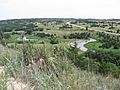
A view of the Dismal River, Nebraska Sandhills, and US 83 in Thomas County, Nebraska
-
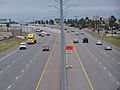
US 83 (along with I-2) traveling through a major retail district of McAllen, Texas.
-
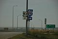
Looking south at the intersection of US 83 and I-90 in Murdo, South Dakota


See also
 In Spanish: U.S. Route 83 para niños
