
Fort Pierre, South Dakota facts for kids
Quick facts for kids
Fort Pierre
|
|
|---|---|

Main and Deadwood streets in Fort Pierre, South Dakota
|
|
| Motto(s):
"Where The West Begins"
|
|

Location in Stanley County and the state of South Dakota
|
|
| Country | United States |
| State | South Dakota |
| County | Stanley |
| Founded | 1867 |
| Incorporated | June 2, 1890 |
| Area | |
| • Total | 3.17 sq mi (8.20 km2) |
| • Land | 3.12 sq mi (8.08 km2) |
| • Water | 0.05 sq mi (0.12 km2) |
| Elevation | 1,440 ft (439 m) |
| Population
(2020)
|
|
| • Total | 2,115 |
| • Estimate
(2022)
|
2,142 |
| • Density | 678.10/sq mi (261.84/km2) |
| Time zone | UTC–7 (Mountain (MST)) |
| • Summer (DST) | UTC–6 (MDT) |
| ZIP code |
57532
|
| Area code(s) | 605 |
| FIPS code | 46-22260 |
| GNIS feature ID | 1267393 |
Fort Pierre is a city in Stanley County, South Dakota, United States. It's an important city in the Pierre, South Dakota micropolitan area and is the main city (called the county seat) of Stanley County. In 2020, about 2,115 people lived there.
The city of Fort Pierre grew around a trading post and fort built in 1832. This fort was located on the west side of the Missouri River, close to where the Bad River flows into it. French explorers first visited this area in the early 1700s. An American trading post had been here since 1817. In 2017, the city celebrated 200 years of people living there continuously!
Contents
History of Fort Pierre
Early Explorers and Land Claims
On March 30, 1743, two French explorers, Francois and Louis-Joseph Gaultier de La Vérendrye, arrived in the area where Fort Pierre is today. They were on an expedition from Quebec, which was a French colony in what is now Canada. To claim the land for the King of France, they buried a special lead plate in a nearby hill.
Later, in 1803, the United States bought this huge area, along with much more land west of the Mississippi River, from France. This big purchase was called the Louisiana Purchase.
Lewis and Clark Expedition
In 1804, President Thomas Jefferson sent the Lewis and Clark Corps of Discovery to explore this new territory. They hoped to find a water route to the Pacific Ocean. From September 24 to 28, 1804, they met with the Teton Sioux people near the mouth of the Bad River.
The Fur Trade and Fort Pierre's Founding
In 1817, a fur trader named Joseph La Framboise, Jr., who worked for the American Fur Company, set up a trading post called Fort Tecumseh. It was about a mile north of the current city, on what is now La Framboise Island in the Missouri River. The fur trade was very profitable, attracting many traders.
In 1832, Pierre Chouteau, Jr., a major fur trader from St. Louis, built a new and stronger trading post. This new fort, called Fort Pierre Chouteau, was on the west side of the Missouri River, north of the Bad River's mouth. The city of Fort Pierre slowly grew around this important trading post.
In 2017, Fort Pierre celebrated its 200th birthday, marking two centuries of people living continuously at the meeting point of the Missouri and Bad rivers.
Pierre Becomes the Capital
In 1880, the city of Pierre was founded on the east side of the Missouri River. It was located in Hughes County. Because Pierre was in the center of the state and was reached by the railroad first, the state government chose it as the state capital when South Dakota became a state.
Geography of Fort Pierre
Fort Pierre is located right across the Missouri River from Pierre, which is the state capital of South Dakota.
According to the United States Census Bureau, Fort Pierre covers a total area of about 3.16 square miles (8.20 square kilometers). Most of this area, about 3.11 square miles (8.08 square kilometers), is land. A small part, about 0.05 square miles (0.12 square kilometers), is water.
Even though Fort Pierre is officially in the Mountain Time Zone, most people who live there use Central Time. This is because they have strong social and economic connections with Pierre, which is in the Central Time Zone.
Demographics of Fort Pierre
| Historical population | |||
|---|---|---|---|
| Census | Pop. | %± | |
| 1880 | 287 | — | |
| 1890 | 360 | 25.4% | |
| 1900 | 395 | 9.7% | |
| 1910 | 792 | 100.5% | |
| 1920 | 805 | 1.6% | |
| 1930 | 683 | −15.2% | |
| 1940 | 764 | 11.9% | |
| 1950 | 951 | 24.5% | |
| 1960 | 2,649 | 178.5% | |
| 1970 | 1,448 | −45.3% | |
| 1980 | 1,789 | 23.5% | |
| 1990 | 1,854 | 3.6% | |
| 2000 | 1,991 | 7.4% | |
| 2010 | 2,078 | 4.4% | |
| 2020 | 2,115 | 1.8% | |
| 2022 (est.) | 2,142 | 3.1% | |
| U.S. Decennial Census 2020 Census |
|||
Fort Pierre Population in 2010
Based on the census from 2010, there were 2,078 people living in Fort Pierre. These people lived in 893 households, and 586 of these were families. The population density was about 668.2 people per square mile (258.0 people per square kilometer). There were 959 homes in total, with an average of 308.4 homes per square mile (119.1 homes per square kilometer).
Most of the people in the city were White (89.4%). There were also Native American people (6.6%), African American people (0.3%), and Asian people (0.2%). About 3.3% of the population identified as two or more races. People who identified as Hispanic or Latino made up 0.7% of the population.
Out of the 893 households, 30.5% had children under 18 living with them. About 51.6% were married couples living together. Some households had a female head with no husband (9.7%), or a male head with no wife (4.3%). About 34.4% of households were not families.
Roughly 30.6% of all households were made up of individuals living alone. About 11.2% of households had someone aged 65 or older living by themselves. The average household had 2.33 people, and the average family had 2.86 people.
The average age of people in the city was 41.8 years old. About 24.1% of residents were under 18. About 6.6% were between 18 and 24, and 23.2% were between 25 and 44. People aged 45 to 64 made up 30% of the population, and 16% were 65 years or older. The city had slightly more females (50.6%) than males (49.4%).
Climate in Fort Pierre
The weather information for Fort Pierre comes from a weather station located about 17 miles (27 km) west-southwest of the city, near Wendte. Fort Pierre once recorded a temperature of 120 °F (49 °C). This is tied for the highest temperature ever recorded in the state of South Dakota! The other time this temperature was reached was in 1934 at Gann Valley.
| Climate data for Fort Pierre, SD | |||||||||||||
|---|---|---|---|---|---|---|---|---|---|---|---|---|---|
| Month | Jan | Feb | Mar | Apr | May | Jun | Jul | Aug | Sep | Oct | Nov | Dec | Year |
| Record high °F (°C) | 75 (24) |
76 (24) |
88 (31) |
99 (37) |
105 (41) |
111 (44) |
120 (49) |
111 (44) |
110 (43) |
101 (38) |
87 (31) |
75 (24) |
120 (49) |
| Mean daily maximum °F (°C) | 33.5 (0.8) |
38.6 (3.7) |
49.9 (9.9) |
62.5 (16.9) |
72.8 (22.7) |
82.5 (28.1) |
90.3 (32.4) |
90.1 (32.3) |
80.6 (27.0) |
64.4 (18.0) |
47.7 (8.7) |
35.0 (1.7) |
62.3 (16.8) |
| Mean daily minimum °F (°C) | 8.2 (−13.2) |
12.8 (−10.7) |
23.2 (−4.9) |
34.1 (1.2) |
45.2 (7.3) |
55.5 (13.1) |
61.5 (16.4) |
59.4 (15.2) |
48.5 (9.2) |
35.0 (1.7) |
21.3 (−5.9) |
10.7 (−11.8) |
34.6 (1.5) |
| Record low °F (°C) | −44 (−42) |
−47 (−44) |
−26 (−32) |
2 (−17) |
19 (−7) |
32 (0) |
43 (6) |
37 (3) |
18 (−8) |
−3 (−19) |
−16 (−27) |
−40 (−40) |
−47 (−44) |
| Average precipitation inches (mm) | 0.34 (8.6) |
0.51 (13) |
1.08 (27) |
1.99 (51) |
2.53 (64) |
2.78 (71) |
2.19 (56) |
1.66 (42) |
1.41 (36) |
1.33 (34) |
0.53 (13) |
0.37 (9.4) |
16.72 (425) |
| Average snowfall inches (cm) | 5.2 (13) |
6.1 (15) |
5.7 (14) |
3.2 (8.1) |
0.1 (0.25) |
0 (0) |
0 (0) |
0 (0) |
0 (0) |
0.8 (2.0) |
3.5 (8.9) |
4.8 (12) |
29.4 (73.25) |
| Source: http://www.wrcc.dri.edu/cgi-bin/cliMAIN.pl?sd3076 | |||||||||||||
Media in Fort Pierre
Radio Stations
- KGFX (AM) 1060 AM (plays Country music)
- KCCR 1240 AM (plays Adult Contemporary music)
- KGFX-FM 92.7 FM (plays Adult Contemporary music)
- KPLO-FM 94.5 FM (plays Country music)
- KLXS 95.3 FM (plays Classic Hits)
- KJBI 100.1 FM (plays Classic Hits)
Television Channels
The local newspaper for Fort Pierre is called the Capital Journal.
Notable People from Fort Pierre
- Pierre Chouteau Jr. (1789-1865) - A French merchant and trader. The cities of Pierre and Fort Pierre are named after him.
- Walter Dale Miller - A former governor of South Dakota.
- George Philip Jr. - A naval officer during World War II. He commanded the USS Twiggs (DD-591) and received the Navy Cross award. A ship, USS George Philip (FFG-12), was named after him.
- Clint Roberts - A former U.S. Representative (a member of the U.S. Congress).
- Casey Tibbs - A famous American cowboy and actor.
- John C. Waldron - A World War II aviator (pilot) from Fort Pierre.
Images for kids
-
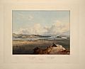
Fort Pierre and the nearby prairie around 1833. This image is an aquatint by Karl Bodmer from a book about his travels.
.jpg)
See also
 In Spanish: Fort Pierre (Dakota del Sur) para niños
