
Brownsville, Texas facts for kids
Quick facts for kids
Brownsville, Texas
|
||
|---|---|---|

Images from left to right, top to bottom Cameron County Courthouse (1914), Reynaldo G. Garza & Filemon B. Vela Courthouse, Cameron County Administrative Building, Port of Brownsville, La Plaza Multimodal Terminal, TSC Performing Arts Center, U.S. Post Office, Villa del Sol Apartments, Market Square, Resaca, Hotel El Jardin, Lone Star National Bank Tower
|
||
|
||
| Nickname(s):
Chess Capital of Texas
|
||
| Motto(s):
"On the Border, By the Sea, and Beyond!"
|
||

Brownsville, Texas
Location in Texas

Brownsville, Texas
Location in the United States

Brownsville, Texas
Location in North America
|
||
| Country | United States | |
| State | Texas | |
| County | Cameron | |
| Founded | 1848 | |
| Incorporated | February 7, 1853 | |
| Named for | Fort Brown, named for Jacob Brown | |
| Government | ||
| • Type | Council-manager | |
| Area | ||
| • City | 145.19 sq mi (376.03 km2) | |
| • Land | 131.53 sq mi (340.66 km2) | |
| • Water | 13.66 sq mi (35.37 km2) 4% | |
| • Metro | 370.58 sq mi (905.76 km2) | |
| Elevation | 33 ft (10 m) | |
| Population
(2020)
|
||
| • City | 186,738 | |
| • Density | 1,420/sq mi (548.2/km2) | |
| • Urban | 216,444 (US: 178th) | |
| • Urban density | 3,485.3/sq mi (1,345.7/km2) | |
| • Metro | 421,017 (US: 130th) | |
| • Metro density | 472.5/sq mi (182.4/km2) | |
| • CSA | 441,181 (US: 94th) | |
| Demonym(s) | Brownsvillian | |
| Time zone | UTC−6 (CST) | |
| • Summer (DST) | UTC−5 (CDT) | |
| ZIP Codes |
78520–78523, 78526
|
|
| Area code(s) | 956 | |
| FIPS code | 48-10768 | |
| GNIS feature ID | 1372749 | |
| Airport | Brownsville/South Padre Island International Airport KBRO (BRO) | |
| α. ^ Area, city density, metro population/density and CSA population/density as of the 2017 estimate. β. Urban population/density as of the 2020 Census. |
||

Brownsville (/ˈbraʊnzvɪl/ BROWNZ-vil) is a city in the U.S. state of Texas. It is the main city of Cameron County. Brownsville is located on the western Gulf Coast in South Texas. It is right next to the border with Matamoros, Tamaulipas, Mexico.
The city covers about 145 square miles (376 square kilometers). In 2020, its population was 186,738 people. This makes it the 139th-largest city in the United States. It is also the 18th-largest city in Texas. Brownsville is part of the larger Matamoros–Brownsville metropolitan area. The city is famous for its warm, subtropical weather all year. It also has a deep-water seaport and a rich Hispanic culture.
An American businessman named Charles Stillman founded Brownsville in 1848. He started a successful river-boat company nearby. The city was named after Fort Brown. This fort was named for Major Jacob Brown. He was a U.S. Army soldier who died during the Mexican–American War (1846–1848). The city and county governments are big employers in Brownsville. Other main jobs are in services, trade, and making things. There's also a growing aerospace and space transportation industry. Brownsville trades with other countries through the Port of Brownsville. The city grew a lot in the early 1900s when steel production was popular.
Brownsville has many historic homes and battle sites. These are listed on the National Register of Historic Places. The city played a big part in the Mexican–American War. Important events included the siege of Fort Texas and the first battles: The Battle of Palo Alto and the Battle of Resaca de la Palma. Several key events of the American Civil War also happened here. These include the Battle of Brownsville and the Battle of Palmito Ranch. The city was also involved in the Texas Revolution. Brownsville's special location makes it a great place for wildlife. Many state parks and historical sites are protected by the Texas Parks and Wildlife Department.
Most people in Brownsville are Hispanic. About 93.9% of the population is Hispanic. This is one of the highest percentages in the United States outside of Puerto Rico.
Contents
- Brownsville's History
- Brownsville's Geography and Climate
- People in Brownsville
- Brownsville's Economy
- Parks and Fun in Brownsville
- Education in Brownsville
- Brownsville's Transportation
- Arts and Culture in Brownsville
- Media in Brownsville
- Notable People from Brownsville
- Sister City
- Images for kids
- See also
Brownsville's History
How Brownsville Started

In 1781, Spanish officials gave a large piece of land to José Salvador de la Garza. He built a ranch there. In the early 1800s, people called the area los tejidos, meaning "pasturelands". A few settlers lived there around 1836. This was when Texas declared its independence from Mexico.
In 1846, President James K. Polk told General Zachary Taylor to move his troops south. Taylor built Fort Texas. It was later renamed Fort Brown to honor Major Jacob Brown. He was a soldier who died during the siege of Fort Texas.
Charles Stillman came to Matamoros in 1828. He helped his father with a business. Brownsville became part of Texas in 1848 after the Treaty of Guadalupe Hidalgo. Stillman and his partners formed the Brownsville Town Company that year. They sold land lots. Stillman officially started the city of Brownsville in late 1848. It became the main city for Cameron County in 1849. The city was first made official in 1850. But this was canceled because of a land dispute. The state made the city official again on February 7, 1853. This is still how it works today. The land ownership issue was finally settled in 1879. The U.S. Supreme Court decided in favor of Stillman.
Brownsville in the Mexican-American War

On April 25, 1846, Captain Seth B. Thornton heard that Mexican troops were crossing the Rio Grande. Thornton and his 63 U.S. dragoons went to Rancho de Carricitos. Mexican General Anastasio Torrejón had already crossed the river. He had 1,600 soldiers. They surrounded Thornton's troops. Thornton's troops had to surrender. Eleven Americans were hurt, and 45 soldiers, including Thornton, were taken prisoner.
When President James K. Polk heard about this, he said, "American blood has been spilled upon the American territory." On May 13, the United States Congress declared war against Mexico.
American General Zachary Taylor left Fort Texas on May 1, 1846. Mexican General Mariano Arista started attacking Fort Texas. This was the first big fight of the Mexican–American War. Taylor was told about the attack and started moving back to Fort Texas. Mexican troops stopped them near Palo Alto. This was about 5 miles (8 km) north of Brownsville. This led to the first battle of the war.
The next day, Mexican troops left. Taylor's troops followed them. This led to the Battle of Resaca de la Palma, which happened in what is now Brownsville. When Taylor got to Fort Texas, he found that two soldiers had died. One was Major Jacob Brown, the fort's leader. He died on May 9 after being hit by a cannonball. General Taylor renamed the fort "Fort Brown" in his honor. There's an old cannon at the University of Texas at Brownsville and Texas Southmost College. It marks the spot where Major Brown was hurt.
Brownsville During the Civil War

During the American Civil War, Brownsville was a key place for smuggling goods. The Confederate (Southern) states used it to send cotton to European ships. This helped them avoid the Union (Northern) blockades. The cotton went through the Mexican port of Bagdad. Brownsville was at the end of the "Cotton Road."
In November 1863, Union troops came to Brownsville. They wanted to take control of Fort Brown. In the Battle of Brownsville, Confederate soldiers left the fort. They blew it up with 8,000 pounds (3,629 kg) of explosives. In 1864, Confederate forces led by Colonel John Salmon Ford took the town back. He became the mayor of Brownsville.
The American Civil War officially ended on April 9, 1865. This was when Robert E. Lee and his Confederate army surrendered to Union commander Ulysses S. Grant. But a final battle happened in Brownsville. On May 15, 1865, 34 days after the surrender, the Battle of Palmito Ranch took place. Confederates defeated Union troops. Some historians say this was the very last battle of the American Civil War.
Brownsville in the 20th Century
In the early 1900s, Texas and other Southern states passed new laws. These laws made it harder for African Americans to vote. They also created separate public places for different races. While Hispanic people were considered white by U.S. law, some laws still made it hard for them to take part in politics.
The Brownsville Affair
In 1906, there was a problem in Brownsville called the Brownsville affair. There were growing tensions between white residents and Black soldiers at Fort Brown. One night, a white bartender was killed, and a police officer was hurt. Townspeople blamed the Black soldiers. President Theodore Roosevelt unfairly removed all 167 soldiers from the army. He said they were part of a "conspiracy of silence." Later investigations in the 1970s showed that the soldiers were not responsible. The Nixon Administration then fixed their records. Fort Brown was closed after World War II in 1945. The city and a college bought the land in 1948.
Brownsville in the 21st Century
Brownsville has been in the news a lot because of immigration and border wall discussions. In 2006, President George W. Bush signed a law to build a border "fence." This fence would go from the Pacific Ocean to the Port of Brownsville. In 2008, the government wanted to add 70 miles (113 km) more fence. This plan would have taken some land from the University of Texas at Brownsville. It would have moved historical sites and a golf course to Mexico. A judge stopped this plan.
The Border Wall Discussion
In 2016, Donald Trump suggested building a border wall along the U.S.-Mexico border. This wall would be 2,000 miles (3,219 km) long. It would include the area around Brownsville. In 2017, after becoming president, Trump ordered the wall's construction. Brownsville was also part of a discussion about housing immigrant children. The Casa Padre center in Brownsville is the largest place in America for young immigrants.
Making Downtown Brownsville Better
Downtown Brownsville has had many projects to make it better. The goal is to bring more tourists and make it safer. In 2016, the Texas Historical Commission named Brownsville part of its Main Street Program. Several old buildings were fixed up. This included the Stegman Building, named after a streetcar developer.
The Environmental Protection Agency (EPA) chose Brownsville for its "Greening America's Communities" program. They worked on fixing up Market Square, a building from 1850. The city also got a $3.4 million grant to improve building fronts.
Brownsville's Geography and Climate

Brownsville is one of the southernmost cities in the contiguous United States. Only a few cities in Florida are farther south. The city covers about 84.867 square miles (219.80 km2). Most of this is land, and a small part is water.
Brownsville is where several different climate zones meet. These include the subtropics, the Chihuahuan Desert, and the Gulf Coastal Plain. This mix attracts many migratory birds. It also creates a special environment for plants and animals. Brownsville has a unique network of resacas. These are oxbow lakes, which are old parts of the Rio Grande. They provide homes for many birds, especially during spring and fall migrations. Brownsville's natural plant life is mostly grassland.
Brownsville's Metropolitan Area
Brownsville is part of a larger metropolitan area. This area includes Cameron County and Willacy County. It is called the Brownsville–Harlingen–Raymondville combined statistical area. In 2017, about 445,309 people lived there. This makes it the 106th-largest combined area in the United States.
In 2011, Brownsville was one of the first U.S. cities to charge a fee for plastic shopping bags. This was to help reduce pollution. But in 2018, the Supreme Court of Texas said this rule was illegal. Forbes magazine named Brownsville one of the 12 U.S. cities with the cleanest air. In 2018, the Brownsville–Harlingen area was listed among the "Cleanest U.S. Cities for Ozone Air Pollution."
Plants and Soil in Brownsville

Brownsville has more broadleaf evergreen plants, like palms, than other nearby Texas cities. The Sabal mexicana (Texas sabal palm) is native to Brownsville. It is the only palm species in Texas with a big trunk. Brownsville has one of the last natural groups of these palms. Other native plants include Citharexylum berlandieri (Tamaulipan fiddlewood) and Leucophyllum frutescens (Texas sage).
The soil in Brownsville is mostly clay. It can be salty in many places. Other soil types include Cameron clay and Laredo silt loam. Because Brownsville is near the coast, Lomalta clay is common in swampy areas. Some parts of the city can flood easily. This is because the land is flat, the clay soil doesn't let water through well, and there isn't enough money for good drainage systems.
The United States Geological Survey says Brownsville's soil is mainly from river deposits and wind. Most of the soil comes from the Rio Grande floodplain. It has clay, sand, silt, gravel, and organic matter. Windblown deposits are made of "active dunes" with clay and silt near the coast. Inland, they have clay, sand, and silt.
Brownsville's Climate
Brownsville has a humid subtropical climate (Köppen Cfa). Winters are warm, and summers are hot and humid. Because it's on the Gulf Coast, its climate is very close to a tropical savanna climate. It also borders a hot semi-arid climate due to its closeness to deserts.
Snow is very rare in Brownsville. The wet season is in late summer and early fall, especially in September. This is when tropical cyclones are most likely. From November to April, it is usually dry. Brownsville gets about 26.78 inches (68.0 cm) of rain each year.
The average temperature in January is 62.9°F (17.2°C). In August, it's 87°F (30.6°C). In summer, temperatures often go above 90°F (32°C). They rarely go above 100°F (38°C). The hottest temperature ever recorded in Brownsville was 106°F (41°C) on March 27, 1984, and August 28, 2023. Freezing temperatures happen only once or twice a year. On December 25, 2004, Brownsville had its first measurable snow in 109 years. It was 1.5 inches (3.8 cm) of snow, making it a rare White Christmas. The coldest temperature ever recorded was 12°F (-11°C) on February 13, 1899. In 2016, Brownsville was ranked the fifth-hottest city in America.
| Climate data for Brownsville/South Padre Island International Airport, Texas (1991−2020 normals, extremes 1878−present) | |||||||||||||
|---|---|---|---|---|---|---|---|---|---|---|---|---|---|
| Month | Jan | Feb | Mar | Apr | May | Jun | Jul | Aug | Sep | Oct | Nov | Dec | Year |
| Record high °F (°C) | 95 (35) |
94 (34) |
106 (41) |
104 (40) |
104 (40) |
104 (40) |
104 (40) |
106 (41) |
105 (41) |
99 (37) |
98 (37) |
94 (34) |
106 (41) |
| Mean maximum °F (°C) | 83.9 (28.8) |
87.1 (30.6) |
91.4 (33.0) |
94.8 (34.9) |
95.3 (35.2) |
97.2 (36.2) |
98.0 (36.7) |
99.1 (37.3) |
97.2 (36.2) |
93.1 (33.9) |
88.7 (31.5) |
85.3 (29.6) |
100.7 (38.2) |
| Mean daily maximum °F (°C) | 72.6 (22.6) |
76.2 (24.6) |
80.6 (27.0) |
85.7 (29.8) |
90.3 (32.4) |
94.0 (34.4) |
95.0 (35.0) |
96.3 (35.7) |
92.2 (33.4) |
87.3 (30.7) |
80.3 (26.8) |
74.2 (23.4) |
85.4 (29.7) |
| Daily mean °F (°C) | 62.9 (17.2) |
66.5 (19.2) |
71.3 (21.8) |
76.7 (24.8) |
82.0 (27.8) |
85.6 (29.8) |
86.4 (30.2) |
87.0 (30.6) |
83.4 (28.6) |
77.9 (25.5) |
70.5 (21.4) |
64.4 (18.0) |
76.2 (24.6) |
| Mean daily minimum °F (°C) | 53.1 (11.7) |
56.9 (13.8) |
62.0 (16.7) |
67.7 (19.8) |
73.7 (23.2) |
77.2 (25.1) |
77.8 (25.4) |
77.8 (25.4) |
74.7 (23.7) |
68.6 (20.3) |
60.8 (16.0) |
54.7 (12.6) |
67.1 (19.5) |
| Mean minimum °F (°C) | 36.4 (2.4) |
40.1 (4.5) |
43.8 (6.6) |
50.9 (10.5) |
60.9 (16.1) |
70.4 (21.3) |
72.8 (22.7) |
72.7 (22.6) |
64.7 (18.2) |
51.9 (11.1) |
42.5 (5.8) |
36.5 (2.5) |
33.7 (0.9) |
| Record low °F (°C) | 18 (−8) |
12 (−11) |
28 (−2) |
37 (3) |
41 (5) |
56 (13) |
58 (14) |
63 (17) |
51 (11) |
35 (2) |
27 (−3) |
16 (−9) |
12 (−11) |
| Average precipitation inches (mm) | 1.08 (27) |
1.03 (26) |
1.45 (37) |
1.47 (37) |
2.22 (56) |
2.86 (73) |
1.98 (50) |
2.16 (55) |
5.73 (146) |
3.83 (97) |
1.76 (45) |
1.21 (31) |
26.78 (680) |
| Average precipitation days (≥ 0.01 in) | 7.0 | 5.3 | 5.3 | 4.5 | 4.8 | 5.8 | 4.8 | 6.1 | 11.1 | 7.6 | 7.0 | 7.5 | 76.8 |
| Average relative humidity (%) | 79.3 | 77.4 | 74.6 | 75.1 | 76.5 | 75.0 | 73.2 | 73.8 | 76.3 | 75.3 | 76.1 | 78.2 | 75.9 |
| Mean monthly sunshine hours | 130.6 | 151.3 | 206.8 | 232.7 | 266.4 | 306.5 | 334.4 | 306.4 | 252.0 | 228.3 | 166.2 | 130.7 | 2,712.3 |
| Percent possible sunshine | 39 | 48 | 56 | 61 | 64 | 74 | 79 | 76 | 68 | 64 | 51 | 40 | 61 |
| Source: NOAA (relative humidity and sun 1961−1990) | |||||||||||||
People in Brownsville
| Historical population | |||
|---|---|---|---|
| Census | Pop. | %± | |
| 1850 | 2,734 | — | |
| 1860 | 2,734 | 0.0% | |
| 1870 | 4,905 | 79.4% | |
| 1880 | 4,938 | 0.7% | |
| 1890 | 6,134 | 24.2% | |
| 1900 | 6,305 | 2.8% | |
| 1910 | 10,517 | 66.8% | |
| 1920 | 11,791 | 12.1% | |
| 1930 | 22,021 | 86.8% | |
| 1940 | 22,083 | 0.3% | |
| 1950 | 35,086 | 58.9% | |
| 1960 | 48,040 | 36.9% | |
| 1970 | 52,522 | 9.3% | |
| 1980 | 84,997 | 61.8% | |
| 1990 | 98,962 | 16.4% | |
| 2000 | 139,722 | 41.2% | |
| 2010 | 175,023 | 25.3% | |
| 2020 | 186,738 | 6.7% | |
| U.S. Decennial Census 1850–1900 1910 1920 1930 1940 1950 1960 1970 1980 1990 2000 2010 |
|||
Brownsville is the 18th-largest city in Texas by population. It has one of the highest percentages of Hispanic residents in the U.S. The Pew Research Center says its metropolitan area has about 373,000 Hispanic people. This is about 88.7% of the population. Of these, most (96.7%) are of Mexican heritage.
Brownsville's Population in 2020
In 2020, Brownsville had 186,738 people. There were 53,506 households and 42,240 families. About 93.88% of the people were Hispanic or Latino. The average age in Brownsville was 29.9 years old. About 12% of the people were 65 or older. About 25.9% of the population was born in another country. The average household income was $47,435. Brownsville faces economic challenges, with a notable percentage of its population experiencing poverty.
Brownsville's Economy
.jpg)
Brownsville's economy relies on service and manufacturing jobs. The government and the University of Texas Rio Grande Valley are big employers. Education, aerospace, and space transportation are also important industries. In the early 1900s, the city's population grew because of a boom in farming. Brownsville's warm climate makes it a center for the citrus fruit industry.
The Port of Brownsville brings a lot of money to the city. The port is about 2 miles (3 km) from the city. It connects roads from Mexico to the Gulf Intracoastal Waterway in Texas. The port is a key economic hub for South Texas. Ships arrive from other parts of the U.S., Mexico, and other countries. The port also recycles ships. It has five of the country's eight ship-recycling companies. It received a $1.8 million grant to help businesses and build new things. This grant is expected to create 700 jobs.
Global Trade in Brownsville
Brownsville's economy is mostly based on international trade with Mexico. This trade happens under the North American Free Trade Agreement (NAFTA). Because of the growth of maquiladora (textile factories) in Matamoros, Mexico, Brownsville's air cargo industry grew a lot in the late 1980s. It has one of the fastest-growing manufacturing sectors in the U.S. Brownsville is known for being a good place for businesses. It is also one of the least expensive places to live in the country. In 2016, President Barack Obama signed a bill to make the Brownsville Ship Channel deeper.
Sports in Brownsville
The Sams Memorial Stadium is in Brownsville. It can hold 10,000 people and opened in 1957. The stadium is mainly used for American football and soccer.
FC Brownsville is a soccer team that started in 2015. They joined the National Premier Soccer League in 2018. The team plays its home games at the Brownsville Sports Park. In 2023, FC Brownsville won the NPSL Lone Star Conference championship.
Technology and Space in Brownsville
In 2014, entrepreneur Elon Musk announced the building of the SpaceX South Texas launch site. This site, now called Starbase, is a spaceport for private spaceflight. It is located east of Brownsville on the Gulf Coast. This launch facility is expected to bring $85 million to Brownsville. It should also create about 500 jobs, with $51 million in yearly salaries. The facility was expected to hire 75–100 full-time workers at first. By 2019, it could have up to 150 full-time employees. Elon Musk also helped fund improvements in downtown Brownsville, with new restaurants and bars.
Since 2014, the University of Texas at Brownsville and the Brownsville Economic Development Council (BEDC) have worked with SpaceX. They are building radio-frequency (RF) technology centers for STARGATE. This project helps students and teachers learn about radio frequency technologies used in spaceflight. It will also include satellite and spacecraft tracking.
SpaceX's presence has caused home prices in the area to go up. The average home price in April 2022 was $239,000. This was almost $100,000 higher than three years before. The BEDC bought five lots near the SpaceX launch site. They renamed this area the "Stargate" subdivision. This beach location will have a 12,000 square foot (1,115 m2) tracking center. Stargate received several grants, including $1.2 million from the U.S. Economic Development Administration.
Main Employers in Brownsville
Here are the top employers in Brownsville as of May 2015:
| # | Employer | Employees |
|---|---|---|
| 1 | Brownsville Independent School District | 7,670 |
| 2 | Cameron County | 1,950 |
| 3 | University of Texas Rio Grande Valley | 1,734 |
| 4 | Keppel AmFELS | 1,650 |
| 5 | Walmart | 1,413 |
| 6 | Abundant Life Home Health | 1,300 |
| 7 | City of Brownsville | 1,227 |
| 8 | Caring For You Home Health | 1,200 |
| 9 | H-E-B Grocery | 975 |
| 10 | Maximus | 950 |
Parks and Fun in Brownsville

Brownsville has 37 parks. They are connected by a 1,200-acre (4.9 km2) park system. There are also 32 miles (51 km) of bike lanes. The city has three gyms, two public pools, and 55 sports fields.
Because Brownsville is near the coast, it has many protected areas of the United States. Resaca de la Palma State Park is one of six nature preserves. It is part of the World Birding Center. It is the largest preserve in the park system. It has about 1,200 acres (486 ha) of native brushland. This area was also part of the Battle of Resaca de la Palma.
The National Park Service lists the Battle of Palo Alto site as a National Historic Park. The agency bought 300 acres (121 ha) of the land. The park is home to honey mesquite bushes, prickly pear cacti, and yucca plants.
The city has two national wildlife refuges. Laguna Atascosa National Wildlife Refuge is in northeast Cameron County. It protects rare animals like the Texas ocelot and the Aplomado falcon. This refuge is 65,096 acres (263.43 km2). The Lower Rio Grande Valley National Wildlife Refuge is in northwest Cameron County. It is 90,788 acres (36,741 ha). This refuge has trails connected to the Great Texas Coastal Birding Trail.
Boca Chica State Park and Brazos Island State Park are state parks. They were given to the Lower Rio Grande Valley refuge center in 2007. They are 10,680 acres (43.2 km2) and 217 acres (0.88 km2) respectively. Laguna Madre is on the eastern side of the county. It is a long, shallow, salty lagoon. It is one of the most protected lagoon ecosystems in the U.S.
Education in Brownsville
Schools for Kids and Teens
The Brownsville Independent School District (BISD) serves most of the city. In the 2018–2019 school year, it had 44,402 students. About 95% of these students came from families with lower incomes. BISD is the 17th largest school district in Texas. It has seven high schools: Homer Hanna, Gladys Porter, James Pace, Simon Rivera, Lopez, BECHS, and Veterans Memorial.
A part of northern Brownsville is served by the Los Fresnos Consolidated Independent School District. The South Texas Independent School District, which is a special magnet school district, has a medical academy in northern Brownsville. There are also several private religious elementary and middle schools in the community. The Roman Catholic Diocese of Brownsville runs Catholic schools in the Rio Grande Valley, including Brownsville.
Colleges and Universities in Brownsville

Six colleges and universities are in Brownsville. The University of Texas Rio Grande Valley is part of the University of Texas system. It started in 2014 when two other universities merged. It is the 10th-largest university in Texas. In 2018, it had over 25,000 undergraduate students. In 2017, The Hispanic Outlook in Higher Education ranked the university third in the country for giving bachelor's degrees to Hispanic students.
Texas Southmost College is a community college near the southern border of Brownsville. In 2018, it had 7,132 students. Students often transfer to the University of Texas Rio Grande Valley after attending this college. The city also has three vocational schools. These include the South Texas Vocational Technical Institute, Brightwood College campus, and Southern Careers Institute.
The The University of Texas Health Science Center at Houston, School of Public Health (UTSPH), has a campus in Brownsville. It focuses on health issues in the Rio Grande Valley. These include diabetes, obesity, and cardiovascular disease. It also studies genetics and its link to diseases.
Brownsville's Transportation
Main Roads
Brownsville is served by Interstate 69E, which is also U.S. Route 77. This highway connects to cities like Kingsville and Corpus Christi. Other highways in the Brownsville area are U.S. Route 83, U.S. Route 281, SH 4, and SH 48. Interstate 169/SH 550 is a toll road. It connects North Brownsville to the Port of Brownsville. It forms a loop around the outer city limits.
Public Transportation
The Brownsville Metro, started in 1978, is the city's public transportation system. It has three main hubs and 13 routes that cover a large part of Brownsville. It also provides vans for disabled passengers. This system is the only one in its county. In 2015, over 1.3 million people used it.
Air and Bike Travel
The Brownsville/South Padre Island International Airport (BRO) offers daily flights. You can fly nonstop to American Eagle hubs like Dallas/Fort Worth International Airport. You can also fly to George Bush Intercontinental Airport in Houston. The airport received a $12.7 million grant to build a new terminal.
Brownsville has 64 miles (103 km) of trails for hiking and biking. It also has bike lanes on streets. In 2016, a bike-share program started in Brownsville. It worked with the University of Texas Rio Grande Valley.
Railroads
The St. Louis, Brownsville and Mexico Railway reached Brownsville in 1904. In 1910, a railroad bridge was built between Brownsville and Matamoros, Mexico. This brought new settlers to the lower Rio Grande Valley. These settlers cleared land, built irrigation systems, and started large-scale farming. In 1904, H. G. Stillwell Sr. planted the first commercial citrus orchard. This started the citrus fruit industry, which is very important to the valley. The railroad and farming brought new wealth to Brownsville.
Today, the Brownsville and Rio Grande International Railroad (BRG) is based in Brownsville. It operates 45 miles (72 km) of track at the Port of Brownsville. It connects with other major railroads. BRG transports steel, farm products, food, and other goods.
Bridges to Mexico

Brownsville has three international bridges that connect to Mexico. These are the Brownsville & Matamoros International Bridge (B&M), Gateway International Bridge, and the Veterans International Bridge at Los Tomates.
Arts and Culture in Brownsville
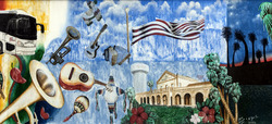
Brownsville is known for its strong Mexican culture. Charro Days is a big celebration shared by Brownsville and Matamoros, Mexico. It includes El Grito, a joyful Mexican shout. Mexican musicians and actors often perform. The Sombrero Festival continues the Charro Days fun. It's a three-day event with performances by tejano, corrido, and other traditional Mexican artists. It also has many contests. In 2016, a Mexican art gallery gave a statue called Mr. Charro to a park.

The city hosts the Latin Jazz Festival every year in early October. It's a three-day celebration of local Latin jazz performers, art, and dance. The festival started in 1997, founded by American musician Tito Puente. Brownsville has more and more art galleries. These include the Puente Art Studio, the B&E Art Studio, and the Rusteberg Art Gallery. The Brownsville Museum of Fine Arts shows Egyptian and Astronomical art. It used to be called the Brownsville Art League.
Brownsville also has several museums with historical items and military equipment. The Historic Brownsville Museum opened in 1986. The building used to be a Spanish Colonial Revival train station. It shows Spanish architecture and has education programs. The Commemorative Air Force Museum has World War II aircraft. It offers tours about early wars in Asia and Europe. It also tells stories of pilots from the 201st Mexican Fighter Squadron.
The Stillman House Museum was built in 1850. It was owned by Charles Stillman and Mexican consul Manuel Pérez Treviño. Important meetings happened here. The house was later bought by Stillman's great-grandson and given to the city. It opened to the public in 1960. The house was damaged by Hurricane Dolly in 2008. It reopened after being fixed up. The Costumes of the Americas Museum shows clothing from indigenous people. It features clothes from several Mexican states and other Latin American countries.
Famous Restaurants
Vera's Backyard Bar-B-Que is the only restaurant in Texas that still serves barbacoa made the traditional way. They cook the meat by pit-smoking it. Other places steam the meat.
Filming Location
Brownsville has been a filming location for several movies:
| Year | Title | Lead actor(s) |
|---|---|---|
| 1981 | Back Roads | Sally Field, Tommy Lee Jones |
| 2012 | Get the Gringo | Mel Gibson |
| 2013 | A Night in Old Mexico | Robert Duvall |
| 2015 | Endgame | Efren Ramirez, Rico Rodriguez |
| 2017 | The Green Ghost | Danny Trejo |
Media in Brownsville
Newspapers
The Brownsville Herald is the city's main daily newspaper. Other newspapers that cover Brownsville include The Monitor and the Valley Morning Star. The Rider is the official weekly campus paper for the University of Texas Rio Grande Valley.
Radio Stations
Here are some FM radio stations you can listen to in Brownsville:
- KBNR (88.3) – Spanish-language Christian music
- KJJF/KHID (88.9) – Relevant Radio
- XHMLS (91.3) – Latin pop
- KESO (92.7) – Classic Hits (70s/80s Hits)
- XHAAA (93.1) – Regional Mexican music
- XHO-FM (93.5) – News/talk
- KFRQ (94.5) – Classic Rock
- KVMV (96.9) – Contemporary Christian music
- XEEW-FM (97.7) – Latin pop
- KKPS (99.5) – Hot AC
- KTEX (100.3) – Country music
- KNVO (101.1) – Spanish Adult Hits
- KBUC (102.1) – Tejano music
- KBFM (104.1) – Rhythmic Top 40
- KJAV (104.9) – Adult Contemporary/Spanish AC Hits
- KXIQ-LP (105.1)
- KRIX (105.5) – Classic Rock
- XHNA (105.9) – Regional Mexican music
- KHKZ (106.3) – Hot AC
- KVLY (107.9) – AC
And here are some AM radio stations:
- KURV (710) – News/Talk
- KVNS (1700) – Sports Talk
Television Stations
Brownsville has three main television stations:
- KVEO-TV (Channel 23; DT 24) – NBC shows
- 23.2 CBS shows
- KNWS-LD (Channel 64; DT 27) – Azteca America shows
- 67.2 CW shows
- KXFX-CD (Channel 67; DT 20) – Fox shows
Notable People from Brownsville
- James Carlos Blake, novelist
- Shelbie Bruce, actress
- José Tomás Canales, lawyer, writer, politician
- Oscar Casares, author and professor
- Osvaldo de León, actor and model
- Buddy Garcia, former Texas Railroad Commissioner
- Reynaldo G. Garza, U.S. Judge
- Tony Garza, former U.S. Ambassador to Mexico
- Gilberto Hinojosa, Texas Democratic Party chairman
- Mifflin Kenedy, rancher and steamboat businessman
- Pierre Yves Kéralum, priest and architect
- Bernard L. Kowalski, film and television director
- Kris Kristofferson, country singer, songwriter, and actor
- Eddie Lucio III, Texas House of Representatives member
- Eddie Lucio Jr., Texas State Senate member
- Bianca Marroquín, theater and television actress
- Dolissa Medina, filmmaker and artist
- Grace Napolitano, U.S. Representative
- Jose Rolando Olvera Jr., U.S. District Judge
- Américo Paredes, author
- Rudy Ruiz, author and entrepreneur
- Ramón Saldívar, scholar
- Julian Schnabel, painter and film director
- Bruce Sterling, author
- Emeraude Toubia, actress
- Benjamin D. Wood, pioneer in learning technologies
- Jaime Zapata, U.S. Immigration and Customs Enforcement agent
Sister City
Images for kids
-
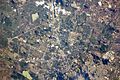
View from the International Space Station, with the photo centered on east Brownsville
See also
 In Spanish: Brownsville para niños
