
National Register of Historic Places listings in Cameron County, Texas facts for kids

Welcome to Cameron County, Texas! This area is full of amazing places that tell stories about the past. These special spots are listed on the National Register of Historic Places. This means they are important for their history, architecture, or what happened there. Think of it like a hall of fame for buildings and sites!
By protecting these places, we make sure that future generations can learn from them. You can even see many of these historic spots on a map if you look up their coordinates. Let's explore some of these cool historic sites in Cameron County!
Contents
Historic Buildings and Homes
Many old buildings and houses in Cameron County have been saved because they are so important. They show us how people lived and worked long ago.
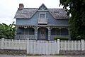
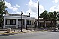
Samuel Wallace Brooks House
The Samuel Wallace Brooks House is a beautiful old home in Brownsville. It was built a long time ago and added to the historic list in 1988. This house helps us imagine what life was like for families in the past.

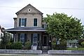
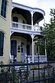
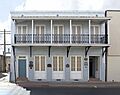
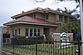
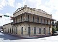
Brown-Wagner House
Another historic home in Brownsville is the Brown-Wagner House. It was recognized in 1977. These old houses are like time capsules, showing us different styles of building from history.

Augustine Celaya House
The Augustine Celaya House, also in Brownsville, became a historic place in 1986. It's another example of the unique architecture from earlier times in the area.

Celaya-Creager House
The Celaya-Creager House was added to the list in 1988. It stands as a reminder of the families who shaped Brownsville.

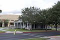
The Gem
Known as "The Gem" or "La Joya," this building in Brownsville was listed in 1991. It's a special place that likely played an important role in the community's history.

Hicks-Gregg House
The Hicks-Gregg House, recognized in 2009, is another significant residence in Brownsville. It helps tell the story of the city's development.

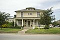
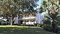
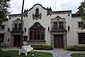
Manautou House
The Manautou House, added in 1983, is one of Brownsville's historic treasures. It shows the architectural styles popular in its time.

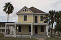
McNair House
The McNair House, listed in 2015, is a more recently recognized historic home in Brownsville. It adds to the rich collection of preserved buildings.

Morris-Browne House
The Morris-Browne House, recognized in 2006, is another important historic home in Brownsville. It helps preserve the look and feel of old Brownsville.

La Nueva Libertad
Also known as the Cueto Building, La Nueva Libertad was listed in 1986. This building is a piece of Brownsville's commercial and social history.

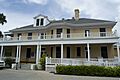
Charles Stillman House
The Charles Stillman House, added in 1979, belonged to a very important person in Brownsville's history. Charles Stillman was a founder of the city. This house is a key part of understanding Brownsville's beginnings.

Important Public and Religious Sites
Beyond homes, many public buildings and places of worship are also considered historic. They often served as centers for community life.
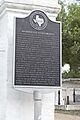
Brownsville City Cemetery and Hebrew Cemetery
These cemeteries, listed in 2010, are more than just burial grounds. They tell the story of the people who lived in Brownsville and the different communities that made up the city.

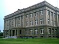
Cameron County Courthouse
The Cameron County Courthouse, built in 1914, was added to the historic list in 1980. Courthouses are often grand buildings that represent the government and justice system of a county.

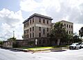
Old Cameron County Jail
The Old Cameron County Jail, recognized in 1995, is another important public building. It shows us what jails were like in the past and how the justice system worked.

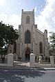
Immaculate Conception Church
The Immaculate Conception Church in Brownsville was listed in 1980. Churches are often central to a community's history and culture, and this one is a beautiful example.

La Madrilena
La Madrilena, added in 1988, is another significant building in Brownsville. Its history likely involves important community gatherings or businesses.

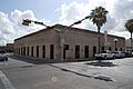
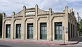
Southern Pacific Railroad Passenger Depot
The Southern Pacific Railroad Passenger Depot, listed in 1978, was a busy place when trains were the main way to travel. It shows the importance of railroads in connecting Brownsville to other places.

Battlefields and Forts
Cameron County also has historic sites related to important battles and military history. These places help us remember significant events in American history.
Fort Brown
Fort Brown, recognized as a National Historic Landmark in 1966, is a very important military site. It played a role in several conflicts, including the Mexican-American War and the American Civil War. It's located on the southern edge of Brownsville.

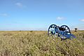
Palmito Ranch Battlefield
The Palmito Ranch Battlefield is a National Historic Landmark, listed in 1996. This site is famous because it was the location of the last battle of the American Civil War, fought after the war officially ended! It's east of Brownsville.
Palo Alto Battlefield National Historical Park
Palo Alto Battlefield is also a National Historic Landmark, recognized in 1966. This is where the first major battle of the Mexican-American War took place. Today, it's a National Historical Park where you can learn all about this important event.

Resaca De La Palma Battlefield
The Resaca De La Palma Battlefield, listed in 1986, was another key battle site during the Mexican-American War. It's now part of the Palo Alto Battlefield National Historical Park, helping to tell the full story of the conflict.
Other Unique Historic Sites
Cameron County has other interesting historic places that don't quite fit into the categories above but are still very important.
Miguel Fernandez Hide Yard
The Miguel Fernandez Hide Yard, also known as El Aleman, was listed in 1990. This site likely played a role in the local economy, perhaps related to the cattle or leather industry.

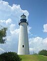
Point Isabel Lighthouse
The Point Isabel Lighthouse, recognized in 1976, is a famous landmark in Port Isabel. Lighthouses were crucial for guiding ships safely to shore. This one is a beautiful reminder of the area's maritime history.

Images for kids
-
The Samuel Wallace Brooks House.
-
The historic Brown-Wagner House.
-
Sign for the Brownsville City Cemetery.
-
The Cameron County Courthouse.
-
The Old Cameron County Jail.
-
The Augustine Celaya House.
-
The Celaya-Creager House.
-
The Miguel Fernandez Hide Yard.
-
The Commandant's House at Fort Brown.
-
The building known as The Gem.
-
The Hicks-Gregg House.
-
The Immaculate Conception Church.
-
La Madrilena building.
-
The Manautou House.
-
The McNair House.
-
The Morris-Browne House.
-
The Cueto Building, also known as La Nueva Libertad.
-

The Palmito Ranch Battlefield.
-
Palo Alto Battlefield National Historical Park.
-
The Point Isabel Lighthouse.
-

The Resaca De La Palma Battlefield.
-
The Southern Pacific Railroad Passenger Depot.
-
The Charles Stillman House.
