
Laguna Madre (United States) facts for kids
Quick facts for kids Laguna Madre |
|
|---|---|

View of the Queen Isabella Causeway over Lower Laguna Madre
|
|

Laguna Madre
Location in Texas

Laguna Madre
Location in the United States
|
|
| Location | South Texas Gulf Coast |
| Coordinates | 26°45′N 97°25′W / 26.750°N 97.417°W |
| Ocean/sea sources | Gulf of Mexico |
| Basin countries | United States |
| Surface area | 280,910 acres (113,680 ha) |
| Settlements | Corpus Christi, Laguna Vista, Port Isabel, Port Mansfield, South Padre Island |
The Laguna Madre is a long, shallow body of water found along the coast of Texas, United States. It's a special type of lagoon that is very salty, even saltier than the ocean! It stretches across several counties in South Texas.
Laguna Madre is one of seven main estuaries (places where fresh river water mixes with salty ocean water) along the Texas Gulf Coast. It's about 130 miles (209 km) long, which is the same length as Padre Island in the US. A narrow strip of land called the Saltillo Flats divides it into two parts: the Upper and Lower Laguna Madre. These two parts are connected by the Intracoastal Waterway, a channel that has been dug through the lagoon.
Important parts of the Laguna Madre include Baffin Bay in the Upper section, Red Fish Bay, and South Bay near the border with Mexico. The Laguna Madre in the United States is actually the northern half of a much larger natural area. This area extends into Mexico for about 144 miles (233 km) south of the US border.
The special environment of the Laguna Madre is protected by places like the Laguna Atascosa National Wildlife Refuge and the Padre Island National Seashore. Large private lands, like the King Ranch, also help protect the area. People have lived near the Laguna Madre for a very long time, and towns like Port Isabel and Port Mansfield are located on its shores.
Contents
History of Laguna Madre
Laguna Madre was formed about 3,000 years ago. This happened after the sea level in Texas became stable, and Padre Island rose up. An older part of the lagoon, Baffin Bay, formed over 12,000 years ago during the Pleistocene Ice Age.
Early people used to gather oysters from the bay. But as the Laguna Madre fully formed and its saltiness changed, the oysters disappeared. The first people to live near the new lagoon were likely the Karankawa and Coahuiltecan Native American tribes.
The Spanish explorer Alonso Álvarez de Pineda is thought to be the first European to see Laguna Madre. This was in the early 1500s. He is believed to have given it the name "Laguna Madre," which means "mother lagoon" in Spanish.
Over time, the Spanish government gave out large areas of land for ranching near the lagoon. One of the first was given to José Nicolás Cabazos in 1792. This land was huge, about 500,000 acres (2,023 sq km)! He raised many cattle there.
After the Mexican–American War, American ranchers also settled in the area. One famous ranch, the King Ranch, was started in 1847 by Richard King.
The area near today's Port Isabel became a popular spot for Spaniards in the late 1700s. A settlement called Point Isabel was built there in the 1830s. In 1853, the Point Isabel Lighthouse was built to help guide ships. The town was renamed Port Isabel in 1928.
In 1954, the Queen Isabella Causeway was built across Laguna Madre. This bridge connects Port Isabel to South Padre Island. It was the longest bridge in Texas at the time. A newer bridge was built in 1974. Sadly, part of it collapsed in 2001 after being hit by a barge. This caused a lot of problems for the local economy. The bridge was rebuilt and reopened later that year.
Further north, the town of Port Mansfield was started in 1950. It was named after Joseph J. Mansfield, a US Congressman. He helped get a bill passed to extend the Intracoastal Waterway in the 1940s. The Port Mansfield Ship Channel was dug in 1957. This channel helps bring more seawater into the Lower Laguna Madre. This helps the fishing and shipping industries in Port Mansfield.
Features of Laguna Madre


Laguna Madre is located between the mainland of South Texas and Padre Island. This area has a dry climate and is sometimes called the Wild Horse Desert. The western shore often has sand dunes, yucca plants, prickly pear cacti, and century plants. You might even see an oak tree bent by the wind!
The lagoon is divided by a 20-mile (32 km) stretch of sand flats called the Saltillo Flats. These flats are about 40 miles (64 km) from the northern end near Corpus Christi. The part of the lagoon north of the flats is called the Upper Laguna Madre. It includes Baffin Bay and Bird Island.
The Lower Laguna Madre is the area south of the Saltillo Flats. It goes all the way to South Bay near Port Isabel. The Queen Isabella Causeway crosses this part of the lagoon. Red Fish Bay is also part of the Lower Laguna Madre.
The Laguna Madre is quite shallow and narrow. On average, it's only about 3.6 feet (1.1 meters) deep and 4 to 6 miles (6.4 to 9.7 km) wide. Most areas are even shallower, only about 0.66 to 1.1 feet (20 to 34 cm) deep. However, the Gulf Intracoastal Waterway has been dredged to be 12 feet (3.7 meters) deep and 138 feet (42 meters) wide. This channel runs the entire length of the bay.
You can find two types of hard reefs in the lagoon. Beach rock reefs are made of shells and sand stuck together by a natural cement. Serpulid reefs are formed by tiny worms that build hard tubes.
Why Laguna Madre is So Salty (Hypersalinity)
Laguna Madre is known for being very salty, or "hypersaline." Its saltiness is usually around 36 parts per thousand (ppt), which is a bit saltier than the average ocean water (35 ppt). It's one of only six hypersaline lagoons or bays on Earth! Other super salty places include Sivash in Ukraine and Shark Bay in Australia. The Laguna Madre in Mexico is also very salty and is sometimes considered part of the same system as the Texas Laguna Madre.
There are a few reasons why Laguna Madre is so salty:
- It's quite isolated from other large bodies of water.
- No big rivers flow into it to bring fresh water.
- The climate is dry, and the lagoon is shallow, so a lot of water evaporates, leaving the salt behind.
The lagoon used to be even saltier before the Port Mansfield Gulf Channel was dug. This channel allows a bit more ocean water to flow in. However, not much water flows in or out of the lagoon. The only major source of fresh water comes from rain during tropical storms and hurricanes. The Lower Laguna Madre is usually the saltiest part, averaging around 45 ppt.
Lagoon Ecosystem
The Laguna Madre is a very important and mostly untouched natural area in Texas. It's one of the most protected lagoons in the United States. About 75% of its shores are protected by the Laguna Atascosa National Wildlife Refuge and the Padre Island National Seashore.
Fish, shrimp, and crabs live in the lagoon. These creatures depend on the lagoon's many beds of seagrass for food and shelter. The Laguna Madre has about 80% of all the seagrass found off the Texas Coast! However, this seagrass is sometimes threatened by "brown tides." These are caused by poor water circulation and dredging. Sometimes, too much seawater can replace the seagrass with oyster beds.
Fish in Laguna Madre
Laguna Madre is home to more types of finfish than any other place on the Texas coast. You can find many different species here, including:
- Blue catfish
- Red drum (also known as redfish)
- Spotted seatrout
- Southern flounder
- Black drum
- Striped mullet
- Florida pompano
- Common snook
- And many others!
Birds and Other Animals
Many birds migrate to and live around the Laguna Madre. About 75% of all redhead ducks spend their winters here. Other birds you might see include:
You can also find sea turtles and dolphins in the bay. Near the shore, you might spot cattle, white-tailed deer, nilgai, and bobcats.
Bird Island Basin in Laguna Madre is a great place for birdwatching when it's wet. Many birds gather there, such as black-necked stilts, roseate spoonbills, great egrets, and American white ibis.
Industry and Tourism
The towns of Port Isabel and Port Mansfield rely on fishing and shrimping. In the 1960s, Port Isabel caught about 3.6 million tons of shrimp each year. This was 65% of all the shrimp caught in Texas! In Port Mansfield, the fishing industry has grown a lot since the Port Mansfield Channel opened. This channel helps bring in more redfish, brown shrimp, and flounder.
Because the bay is so protected, not many factories have been built in the area. Environmental groups have worked to protect the lagoon. For example, the Valero Energy Corporation built an oil and gas pipeline from Corpus Christi to the Rio Grande Valley. This helps reduce the need to ship oil and gas by boat along the Intracoastal Waterway, which lowers the risk of spills. Some activists have also spoken out against a proposed wind turbine farm near Baffin Bay. They worry it could harm the beautiful shores and the bird populations.
Tourism is also very important for the communities around the lagoon. Many people visit the beaches of North and South Padre Islands, and they must pass through the Laguna Madre area to get there. Fishing also brings tourists to Port Isabel, where the Texas International Fishing Tournament has been held since 1934. Visitors also enjoy Bird Island, which is popular for windsurfing, kayaking, and other water sports.
Images for kids
-
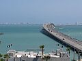
View of the Queen Isabella Causeway over Lower Laguna Madre
-
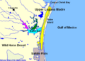
Alazan Bay (dark green), Baffin Bay (light blue), Cayo del Grullo (pink), Upper Laguna Madre (yellow), Laguna Salada (dark brown, directly to the left of Baffin Bay)
-
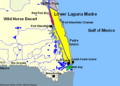
Lower Laguna Madre (yellow), Red Fish Bay (red), South Bay (light green)
See also
 In Spanish: Laguna Madre para niños
